
Maps
- Questions in the exam will be based on topographical maps
- The maps can be from anywhere in the world
- Maps will have a key, scale, northings and eastings
- These all need to be used to answer the questions
Grid references
- 4-figure are used to locate specific grid squares within the map
- The first two figures are the eastings which indicate how far east or west a grid is across the map
- The second two figures are the northings which indicate how far north or south a grid is on the map
- 6-figure grid references are used to locate exact points within grid squares
- The first three figures are the eastings
- The second three figures are the northings
- To find a 4 and 6 figure grid reference
- First, find the four-figure grid reference by giving the number from the bottom of the map first and then the number from the side of the map.

4 - figure grid reference
-
- In image above the 4-figure grid reference would be 17, 51
- To give the 6-figure grid reference you need to image that the grid square is divided into 100 smaller squares

Worked example
Figure 1.1 shows some of the features around the main settlement at Misterblanco in the north east of the map extract.

What is the six-figure grid reference of the junction at point G in Fig 1.1?
[1]
- Answer:
- 994 879
Exam Tip
The paper 2 exam will always contain a map. You will be expected to be able to give and use grid references to locate specific places on the map extract.
Scale
- Maps in the exam will either be scale 1:25,000 where 1cm on the map = 25,000cm (250m) in real life or 1:50,000 where 1cm =50,000cm (500m) in real life
- When the distance is straight or almost straight it can either be measured using a ruler or the edge of a straight piece of paper.
- Using the scale at the bottom of the map mark distances are marked on a piece of paper.
- This can then be laid from the first point to the second point to calculate the distance.

Using scale to measure a straight line
- A distance along a curved route can be divided, the paper rotated and marked in stages to calculate the full distance
- To measure from A to B following the road on the map below the route can be divided into a series of straight sections using crosses.
- The plain piece of paper can then be used to measure from A to the first cross. It should then be rotated, pivoting at the cross to mark the second cross.

Measuring a Curved Route
Bearings
- Directions on a map should always be given using compass points
- There are 16 compass points

Sixteen Compass Points
- A grid bearing is measured from grid north at 0o, East is 90o, South is 180o and West is 270o
- Grid bearings are given using a protractor
- The 0o should be pointing north and the centre of the protractor on the place the bearing is been given from
- The compass direction and grid bearing from the crossroads at A to the location at B

- On the map below B is South West of A
- The bearing is 280o
Height
- Height can be shown in three main ways;
- Spot height
- Contour lines
- Trigonometrical stations
- Spot heights show the height at a specific point with the height measurement written next to it
- Contour lines are isolines. They join points of equal height and are usually at 5 or 10 meter intervals (distance between the contour line)
- This means that the height of the land increases by 5 or 10 meters between the lines
- Trigonometrical station is marked by a small black triangle with a height measurement written next to it
Topography
- The contour lines can also indicate the shape and slope of the land or topography
- Contour lines close together indicates steep land
- Contour lines very far apart indicates gently sloping or flat land dependent on the distance apart
- V-shaped valleys have a v-shaped set of contours
- A hill is shown by a set of circular contour lines

Contour lines
Worked example
Study the map extract and Fig 1 for Stoumont, Belgium. The scale is 1:50000
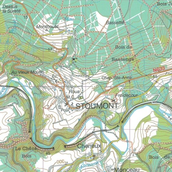
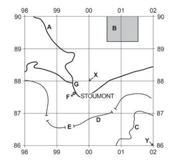
Fig 1
Using the map extract, identify the following features shown in fig 1
The height above sea level of the contour at C
.................... metres
[1]
- Answer:
- 250 metres
Cross-sections
- A cross-section is a slice through the landscape
- They are represented on a map by a line which is often labelled A at one end and B at the other
- They use the contour lines to determine the height of the land

Cross-section on a map
- A piece of paper is then laid along the line and points A and B are marked on
- The contour lines are then marked on each time they cross the paper

Marking on the contour lines
- These figures can then be used to create the cross-section

Exam Tip
In the exam you may be asked to finish a cross-section or interpret a cross-section. When interpreting cross-sections you should include;
- The highest and lowest points
- Comparison of slopes
- Anamolies
Key
- Maps can be used to identify a range of landscape features
- These may be physical and human features
- Each map has a key to show what the symbols mean

Example of a Map Key
