
Spatial Patterns of Land Use
- Land use can be considered the function of place; the main activities of urban areas
- Can be industrial, financial, research and development, homes, or leisure
- Cities can have more than one function
- Most lucrative is tertiary and quaternary services
- Typical land use within cities are:
- Housing
- Industry
- Services
- Transport
- One feature of all urban areas is the spatial sorting of functions and people
- Similar activities and types of people tend to cluster together to create a mosaic within the built-up area
- The mosaic varies from settlement to settlement, over time and space
Urban models
- Models to show how urban land is used, have been developed over the last 90 years
- They try to describe and explain the patterns in a ‘typical’ urban region
- They include social, economic, environmental and political factors
Burgess's concentric zone model 1925
- One of the earliest theoretical models to explain urban social structures and based on the city of Chicago, USA
- It suggests that as cities develop and grow, they move outwards in concentric zones
- Business activity is within the CBD, as this has the most accessible the point
- Next is the “zone of transition”, with older houses converted in light industry and flats
- In-migrants tend to be drawn to this zone for its cheap housing
- Housing improves with distance from the CBD, allowing movement away from the centre and pollution
- High class residential housing is occupied by middle class with it newer and larger houses
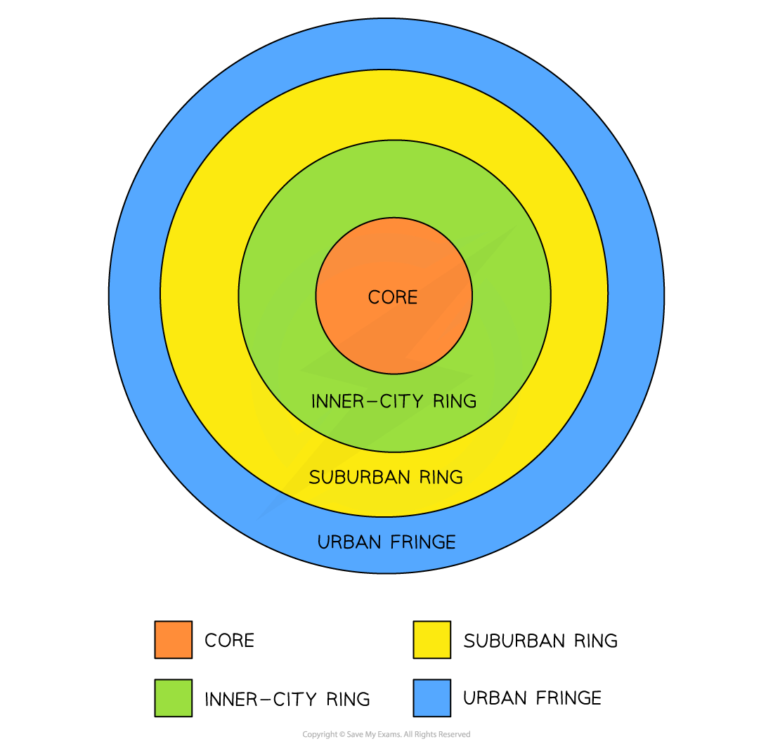
Simplified model of Burgess's concentric ring model
Limitations of the Burgess model
- The model does not take into account the physical landscape
- This was based on Chicago, and yet the city is on the edge of the Great Lakes
- Burgess did not consider the development of commuter towns
- Urban regeneration, renewal and gentrification has changed inner city housing status
- Model does not consider social/council housing
- Decentralisation of shops and industry does not fit with the model
- Fringe developments are not included
- A simple model that explains basic urban growth
Hoyt's sector model 1939
- Hoyt, a student of Burgess, stated that business activity is still within the CBD
- Public transport routes terminated at or near the CBD, giving access for most people
- Industry was noted to follow particular transport routes or corridors
- High class residential areas often developed where there were distinct physical or social attractions (e.g. river)
- Low class residential areas was therefore, confined to unfavourable locations (ugly, less transport links etc,)

Hoyt's sector model - note that high class housing is 'ringed' by middle class housing and is along a corridor, with direct access to the CBD
Limitations to Hoyt's model
- Based on Chicago and again makes little reference to the physical environment
- No reference to out of town developments or commuter settlements
- The growth of a sector can be limited as land use is in blocks (contained)
- Some cities appear to follow this model as it looks at the effects of transport and communication routes
Multi-nuclei model 1945
- Harris and Ullman argued that cities do not develop around a single centre but around important, multiple nuclei
- CBD still exists but not always at the centre of the city
- Low class residential housing tends to be in areas of cheaper land around industry (heavy or light)
- High and middle class residents can afford to avoid living next to industrial areas; these areas are normally on a different side of the city to industry
- There are areas of development outside of the main settlement around new nuclei like out of town shopping centres
- The model is the first to take into consideration of the complexity of the city and its periphery
- It considers that the CBD is not the only part of the city that affects land use
- However, it is still a simplification of urban land use and the physical landscape is not fully considered

Harris and Ullman's multi-nuclei urban model 1945
Bid rent theory
- Bid rent theory shows how the price and demand on land changes as the distance towards the CBD increases
- Different land users will compete with each other for land close to the city centre
- Shops wish to maximise their profitability, so they pay more for land closer to the CBD and less for land further away from this area
- This is based upon the idea that the more accessible an area, the more profitable it is going to be
- The amount people are willing to pay is called Bid Rent

Bid rent model
Limitations
- Very simple, with only 3 broad zones
- It assumes straight lines for cost curves and no scale
- Too graphical, compared to map or plan
- Doesn’t take into account transport networks, planning decisions or physical environment
- Alonso identified that occasionally low income groups are found in the centre of a city, they were in high density cramped residential buildings as rents were high
Peak urban land surface value

- This is a major factor in sorting land uses and people
- Activities and groups differ in what they can afford
- Urban land value tends to decline outwards from the core
- But there are other factors too – geography of the place, flood plains, rivers, waterfronts
- Historical factors
- Economic factors
- Social factors
- Urban land managers – professionals who distribute and control resources – planners, governments, employers, developers, service providers
LDE land use
- CBD in centre as normal
- Industry starts in centre and develops out around transport and water routes
- Zone of lower to middle income residence (also called zone of maturity) is where there is a mixture of old and newer housing occupied by middle classes
- Colonial - high class (elite) residential often develops in a spine out from the city centre
- Around the colonial is a wide range of housing but in the process of improvement e.g. government improvement projects
- Zone of squatter settlements is often on the most undesirable land at the periphery of a city

Based on Griffin and Ford's LDE model of Latin American land use
Exam Tip
Remember:
- Models try to explain differences in structure within cities
- Each model has its limitations
- If you study a city, you must avoid trying to fit it into one model - it probably fits into two or three - Tokyo
- Each city is unique and will have its own structure and life
