
Multiple-Hazard Zone Case Study
- There are many areas in the world which are vulnerable to multiple hazards
- When two or more hazards occur at the same time or in rapid succession the area faces:
- Dealing with a new hazard event whilst still recovering from a previous hazard event
- Issues with development due to the costs of recovering from multiple hazard events
The Philippines
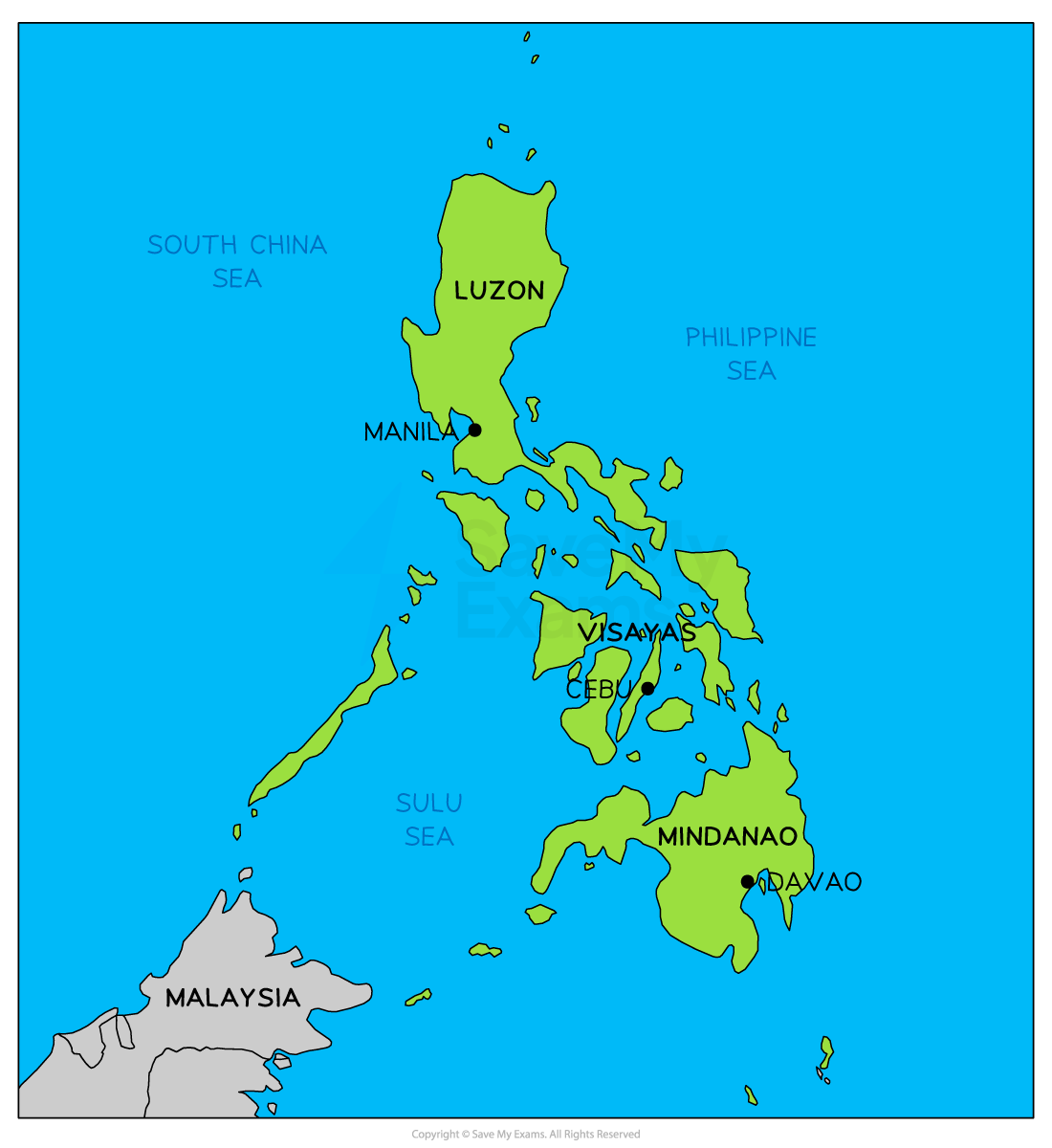
Map of the Philippines
- The Philippines is an island nation situated in Southeast Asia in the Western Pacific Ocean
- It is an archipelago consisting of over 7,600 islands
- The capital is Manila
- The population is estimated at 115.6 million (2022) with a population density of 385.2 people per km2
- Almost 50% of the population is urban
- An estimated 74% of the population and 60% of the land area is vulnerable to hazard events
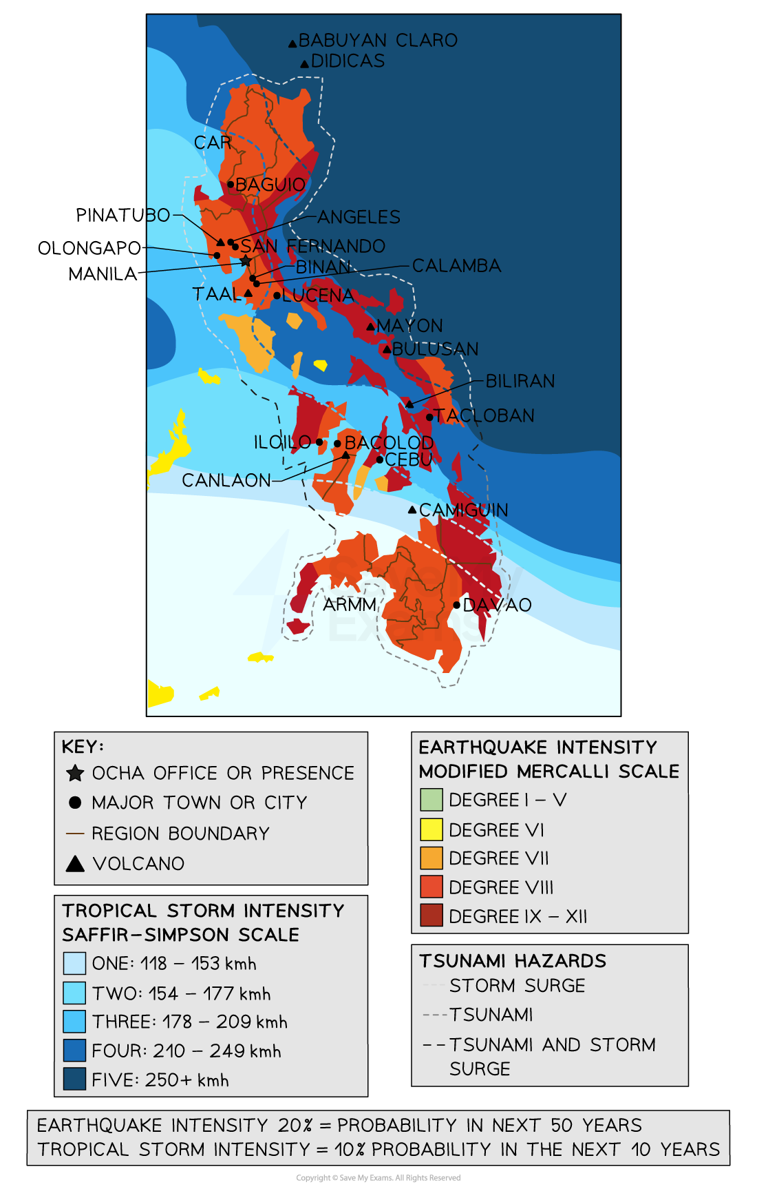
Risk of hazard events
- In 2019 and 2020 the Philippines experienced 4 typhoons, the eruption of the Taal volcano and a number of earthquakes
Tectonic activity
- The Philippines are located at the boundaries of a number of major and minor plate boundaries
- It is on the western edge of the Pacific Ring of Fire
- These are mainly convergent boundaries leading to both volcanoes and earthquakes
Volcanoes and earthquakes
- There are a number of subduction zones around the archipelago which has led to significant volcanic activity
- There are 24 active volcanoes on the islands
- The eruption of Mount Pinatubo in 1991 was until recently the largest eruption in the last 100 years
- Approximately 2.81 million people live within 30km of the Taal volcano
- Mount Mayon has erupted over 50 times in the last 500 years
Tsunami
- The location in the Western Pacific makes the Philippines vulnerable to tsunami
- Tsunami may result from both volcanic eruptions and earthquakes
- The worst tsunami in recorded history occurred in 1976 when tsunami waves of up to 5 meters struck Lebak in the southwest of the Philippines
Typhoons
- The Philippines is located between 5o and 20o north of the equator and lies in the tropical cyclone zone
- Typhoons can occur at any point in the year
- The most active months are June to September
- The islands are affected by between 15-20 typhoons a year
- The most powerful typhoon to strike the Philippines in recent years was Typhoon Yolanda (also known as Haiyan) in 2013
- Wind speeds reached 315km/h and 6,500 people were killed
Landslides
- The mountainous landscape of the Philippines means that landslides are common
- Earthquakes, volcanic eruptions and typhoons can all trigger landslides
Vulnerability
- Increased urbanisation has led to high population densities in cities such as Manila
- The population is mostly coastal as inland areas are mountainous, this increases the vulnerability to storm surges, typhoons and tsunami
- Increasing population has led to deforestation in the upland areas as a result of clearance for settlements and agriculture
- Deforestation increases the risks of landslides as there is less interception and more surface runoff
- More settlements have been built in areas of high risk, Angeles was built near Mount Pinatubo before the eruption in 1991
- The Philippines is a developing country, it lacks money for planning and preparation
- The GDP per capita is US$3,460 compared to the USA which is US$70,248
