
Periglacial Landforms
- The major process that contributes to the production of a periglacial landforms is frost-action
- This leads to vast plains of permafrost with low-growing, marsh vegetation and exposed rocks

Image showing main features of a typical periglacial landscape
- Typical landforms found within a periglacial landscape are:
- Permafrost
- Loess
- Solifluction lobes and terracettes
- Ice wedges and ice lenses
- Patterned ground
- Blockfields/felsenmeer
- Thermokarsts
- Pingos
Loess
- Derived from the German word for 'loose', loess is fine, mineral-rich, windblown material
- Mainly created by wind, but also through glacial action
- As glaciers grind bedrock to a fine powder, called rock flour, meltwater streams carry this to the end of the glacier
- It is this sediment that becomes loess
- Loess can range in thickness from a few centimetres to over 90m
- Unlike most soils, loess is pale, loosely packed and crumbles easily
Blockfields or felsenmeer
- In mountainous/alpine regions, extensive freeze-thaw weathering of the bedrock leaves broken, angular fragments of rock strewn across the landscape
- These areas are subject to intensive, repeated cycles of freezing and thawing
Solifluction lobes and terracettes
- Solifluction is the downward movement of rock and soil under gravity, resulting in lobed-shaped features called solifluction lobes
- Occurs during the summer melt period, when the permafrost's active layer becomes saturated with meltwater and 'slips' downslope
- Terracettes are formed when saturated soil freezes and expands, which forces the soil to shift (heave) upwards towards the surface
- During the spring/summer melt, the soil dries and collapses back vertically
- Each cycle of frost heave and thaw moves the soil downslope, slowly forming a terraced environment
Ice wedges and ice lenses
- Ice wedges form when cracks in the surface fill with summer meltwater and freeze during the winter
- Temperatures have to remain low for cracks to form initially but also to prevent evaporation of water during the melt phase
- Continued freezing and thawing cycles, increase the size of the ice wedges each year
- Ice lenses begin to form when moisture in the soil pools and freezes
- Ice lenses grow with subsequent thawing and refreezing forming a lens-shaped block of ice
- As ice lenses increase in size, they cause soil heave, patterned ground and pingos
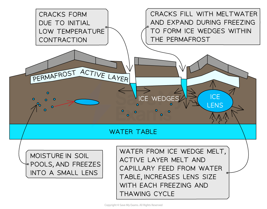
Image showing formation of ice lens and wedge. Note that lenses form when moisture within the soil pool and freeze. Ice wedges initially form when temperatures are low enough for the surface to contract and crack. Meltwater fills these cracks and subsequently freezes, expanding the crack. Further cycles of melting provides water to the forming wedges and lenses, helping them to grow and expand to further 'heave' the ground upwards.
Patterned ground
- The ordered pattern is created through the sorting of sediment, stones and ice wedges
- Shapes include polygons, circles, and stripes
- The repeated freezing, heaving and thawing of the active layer produces the pattern
- Initially freezing sorts material from the rock, and when thawing occurs, redistributes the rock particles into a system of shapes
- Frost heave then pushes larger stones to the surface, which due to its uplift, moves the stones sideways
- Smaller particles are removed via meltwater or wind, which leaves the larger material lying on top of ice wedges, which in turn, marks the polygon pattern
- The sloping ground and gravity, force rocks to move downhill forming elongated stone stripes instead of polygons or circles

Image showing formation of stone patterned ground. Ice wedges form the outer demarcation line of polygon patterned ground, where lighter material is removed by meltwater, leaving the heavier stones behind at the point of the ice wedge during summer melt.
Thermokarsts
- Thermokarsts result from melted ground ice settling unevenly to form marshy ground of hummocks and hollows
- Found mostly in the flat, lowland plains of the Arctic
Pingos
- Found in the Arctic and sub-Arctic region
- These landforms can reach heights of up to 90m
- They have a core of ice and are surrounded on the outside by green vegetation
- There are two forms of pingos:
- Closed system
- Open system
- Closed-system
- Form in areas of continuous permafrost with a lake on the surface
- Lake sediments act as an insulator to the ground beneath, which remains unfrozen, and the permafrost layer
- Liquid water is contained in this unfrozen ground/talik
- When the lake retreats, the ground is no longer insulated and the residual water freezes into a core/lens
- As the permafrost advances, it squeezes the talik and pushes the ice lens and lake sediments towards the surface
- During the summer the ice lens may melt and collapse, leaving a hollow, called an ognip, that fills with water
- Open-system
- Form in areas of discontinuous permafrost
- Groundwater is forced through gaps in the permafrost
- Water rises, accumulates and freezes in the active layer of permafrost, to form an ice lens
- As the groundwater continues to feed the ice lens, the surface domes to form a pingo

Image showing formation of the open and closed pingo system. Note the importance of ice lens/block formation.
Exam Tip
Make sure you can draw and annotate simple sketches of periglacial landforms to help you explain their characteristics and formation in the exam.
Always give an indication of any timescale involved in their formation or changes.
Remember that processes in cold environments take a long time to happen due to the temperatures involved.

