Glacial Meltwater Landforms & Landscapes (Edexcel A Level Geography)

Revision Note

Jacque Cartwright

Expertise

Geography Content Creator

Process of Water Movement

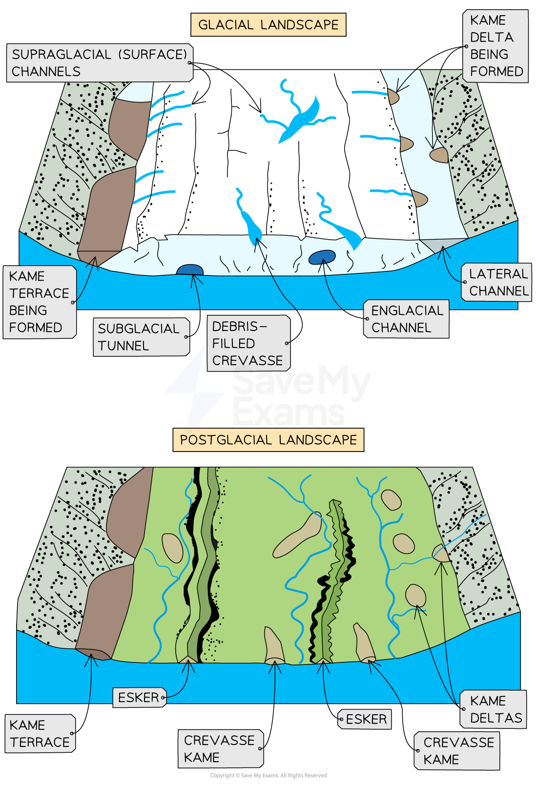
  • Fluvioglacial landscapes are seen at the edges of warm-based and retreating glaciers, 'downstream' of the main glacier field
  • The landscape is associated with flowing meltwater in temperate, peri/glacial regions
  • Unlike polar regions, meltwater is seasonal, plentiful and freely flows from a tunnel at the base of the glacier's snout or across the surface of the glacier and into moulins or crevasses 
  •  As such, a fluvioglacial landscape is considered very dynamic; as meltwater channels frequently change course
fluvioglacial-cross-section

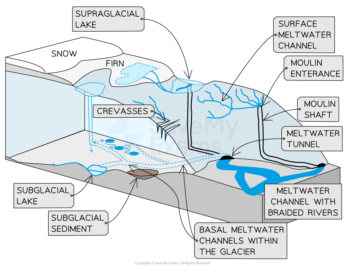
Fluvioglacial cross section

Note that surface meltwater descends through crack/crevasses and moulin shafts to the base of the glacier and exits  through meltwater tunnels at the snout.
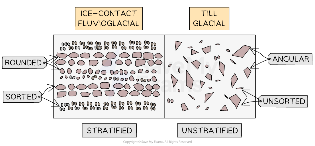
Meltwater

  • Glacial meltwater is cold and loaded with suspended sediment
  • Depending on the type of sediment, it can be milky, grey, or brown in colour
  • Subglacial meltwater exits the snout of the glacier under hydrostatic pressure through meltwater tunnels
  • These tunnels begin under the ice as meltwater caves and vary in size from 50-150m wide, ~20 m high and >14 km in length

Processes

  • Fluvioglacial processes are through erosion and deposition by flowing meltwater 
  • Vast quantities of meltwater are produced, which transport large amounts of debris 
  • Processes include:
    • Basal sliding where meltwater lubricates the warm-based glacier allowing it to flow more easily
    • Nivation is essential in freeze-thaw and meltwater removes the debris, at the edges, during the summer melt 
    • Plucking - the meltwater refreezes and glues to rock fragments 
    • Abrasion - debris 'rubs' the bedrock and produces rock flour

basal-sliding-and-internal-deformation

Basal sliding through meltwater

Glacial & Fluvioglacial Deposits

  • Depositional features through meltwater erosional channels is beneath and in front of the glacier
  • These form distinctive landforms with well-sorted, stratified, rounded and smoothed debris
  • In spring and summer, when glaciers are ablating, levels of meltwater is higher, therefore, larger debris can be carried and deposited
  • In autumn and winter ablation is reduced, as is the capacity of fluvioglacial streams to carry and deposit sediment 
  • This annual cycle produces variations in deposition, and is responsible for contrasting layers within one year - known as glacial varves when found in meltwater lakes or beyond a glacier's margin

  • Fluvioglacial deposits are generally:
    • Smaller than glacial till debris
    • Carry finer material
    • Smoother and rounder through fluvial processes of attrition, abrasion and corrosion
    • Sorted horizontally with coarse material up-valley with progressively finer material being deposited as meltwater moves down-valley 
    • Have stratified layers that reflect seasonal and annual deposition variations
  • Glacial till deposits are typically:
    • Unsorted, angular and non-stratified (non-layered)

difference-between-till-and-fluvio-debris

Differences between till and fluvioglacial debris

Outwash deposits

  • These are zoned into 3:
    • Proximal zone in front of the glacier and emerges from the snout
      • Meltwater has high velocity and particles are large and angular
      • Can be intermixed with finer glacial till
      • Outwash may form alluvial fans
    • Medial zone is where meltwater streams begin to form braided channels
      • Daily and seasonal changes in meltwater discharge 
      • Velocity is decreasing and particle size is rounder and smaller
      • Deposition begins in meanders of streams and across the outwash plain
    • Distal zone is the furthest from the glacial snout
      • The drainage pattern is now similar to normal fluvial drainage systems
      • Outwash is well-sorted, smaller, and rounded

Imbrication

  • Sediments deposited in fast-flowing meltwater channels will show imbrication
  • This is where rock fragments are pushed in one direction by the flow, which forces overlapping of each other

imbrication

Imbrication or layering of rock clasts due to the velocity of meltwater flow

Formation of Fluvio-Glacial Landforms

  • A fluvioglacial landscape can be divided into 2 categories:
    • Ice contact 
    • Proglacial meltwater

Category of Fluvioglacial Landforms

Ice Contact Proglacial

Kames and kame terraces

Eskers

Sandurs/outwash plains and varves

Pro-glacial lakes

Meltwater channels

Kettle holes

Meltwater channels

  • Meltwater channels are formed from erosion due to the flow of meltwater beneath or close to an ice-sheet margin
  • Meltwater channels are typically steep sided, deep and straight 
  • They have a high discharge rate and a turbulent flow 
  • The larger the meltwater channels, the more significant the levels of meltwater erosion and size of deposition 
  • There are different types of channels:
    • Subglacial - found beneath the glacier, with an undulating long profile, and complex, braided stream systems
    • Englacial - where meltwater streams form within the body of the glacial ice - they do not have to exit
    • Lateral - meltwater streams that follow the glacial edge, either within the glacier or on its surface
    • Surface - meltwater flows over the surface of the glacier; the meltwater may flow into crevasses, moulins or supraglacial lakes
    • Proglacial - where meltwater drains from the front of the glacier, downslope and away from the ice margin, eventually forming a network of shallow, sedimented braided channels that are separated by gravel bars (eyots)
  • These processes are the same as rivers 
    • Hydraulic action
    • Abrasion
    • Corrosion
    • Attrition
  • However, meltwater is more erosive, due to the downward pressure of the ice 'squeezing' the meltwater, causing it to flow faster; plus the meltwater carries more debris, which aids in the abrasion and attrition processes
  • Meltwater channels are deep, wide troughs that carry vast amounts of fast-flowing water and are, therefore, highly erosive 
  • As the glacier retreats, the deep channels are left with shallow, slow-flowing streams of water

Outwash plains and varves

  • As meltwater begins to descend, the velocity of the water begins to slow
  • This allows for the formation of a network of shallow, sedimented split channels, that are separated by gravel bars that eventually make up the outwash plain or sandur
  • Tractionsaltationsuspension and solution processes transport the eroded material within the channels
  • The decreasing velocity reduces the ability of the meltwater to 'hold' the debris, sorted sediment is deposited on the valley floor in layers also called varves
  • Varves are frequently defined as a type of glacial lake sediment because they are common in glacial lakes 
  • However, they occur in different environments where sediment layers are laid down annually and not just in glacial lakes

Kettle holes

  • Kettle holes are hollows formed when blocks of ice calved from the main glacier and left on the outwash plain as the glacier retreated
  • The ice block subsequently melts, leaving a depression in the sediment deposits (varves) of the outwash plain
  • Water-filled kettle holes are known as kettle lakes

Eskers

  • These are long, winding ridges of sand and gravel, running parallel to the glacier
  • They are deposited by subglacial meltwater streams and can stretch for several kilometres and reach heights of 30m
  • As the glacier retreats, the stream dries up, and the load remains as an esker
  • Eskers show the position of past glacial tunnels

Kames

  • These are mounds of sand and gravel found on the glacial valley floor
  • Supraglacial meltwater streams collect in surface depressions and deposit layers of debris
  • Glacial retreat dumps the sorted debris onto the glacial valley floor
  • Kame terraces are piles of deposited debris, left by meltwater channels, running between the glacier and the valley sides
  • Similar in appearance to the lateral moraines, however, kames are sorted layers (stratified) with the heaviest gravel at the base and finer sediments on top
  • Proglacial lakes can form in front of glaciers, particularly when the terminal moraine acts as a dam for the meltwater
  • As the proglacial lake develops, velocity is lost and sediment is deposited - these deposits are known as deltas
  • Glacial retreat dumps these deltas on the glacial valley floor, forming delta kames 
  • Crevasse kames are small hummocks of left behind, glacial surface deposited sediments 

Fluvioglacial Landforms

Image showing fluvioglacial landscape of ice contact and proglacial features 

You've read 0 of your 0 free revision notes

Get unlimited access

to absolutely everything:

  • Downloadable PDFs
  • Unlimited Revision Notes
  • Topic Questions
  • Past Papers
  • Model Answers
  • Videos (Maths and Science)

Join the 100,000+ Students that ❤️ Save My Exams

the (exam) results speak for themselves:

Did this page help you?

Jacque Cartwright

Author: Jacque Cartwright

Jacque graduated from the Open University with a BSc in Environmental Science and Geography before doing her PGCE with the University of St David’s, Swansea. Teaching is her passion and has taught across a wide range of specifications – GCSE/IGCSE and IB but particularly loves teaching the A-level Geography. For the last 5 years Jacque has been teaching online for international schools, and she knows what is needed to pass those pesky geography exams.