Syllabus Edition
First teaching 2025
First exams 2027
Image Skills (Cambridge (CIE) IGCSE Geography): Revision Note
Exam code: 0460 & 0976

Photographs
The command word for photographs is usually 'describe'
This is about observational skills and understanding about what is being viewed
When describing, look for:
Physical features: vegetation, climate, relief, drainage, distinct features (cliff, river, desert, landslide, etc.), rocky outcrops, etc.
Human features: grouping of buildings: offices, homes, factories, etc. Urban, rural or fringe settlements. Industry and transport; developed or developing areas and general condition of features: busy, quiet, modern, old, etc.
Relief: height and shape of ground surface, named features, overall appearance
Agriculture: animals—type and spread; vegetation type—grass, barren, sparse, etc. Land type: arable or pasture, ploughed or fallow, crops or harvested, etc. Types of farm buildings and machinery along with their condition
Settlements: rural or urban; features of buildings; types of buildings; use of settlements and buildings; spacing between or among buildings—linear, dispersed, nucleated, etc.
Housing: size and storey: bungalow, large, multistorey, skyscraper, etc. number of windows, are there building plots or vacant sites on the urban fringe or new builds, etc.
Examiner Tips and Tricks
When the exam question asks you to describe, it is asking you to 'say what you can actually see', not 'what you think you see'.
The 'what and why' usually come in a later question.
You will not gain extra marks for explaining, but you will lose out on precious time.
For example, there is a photograph of a black cat and I describe it as follows:
The cat has black fur with a little bit of white on her tummy. Her fur is soft, and she has long whiskers and a stubby tail. She has sharp claws and purrs a lot; she can still bite when annoyed, despite having lost a tooth.
How do I know all this? The photo doesn't reveal if the cat is female, has long claws, lost a tooth, bites, purrs, or has soft fur.
Always remember to say what you can only see in the photograph.
Aerial images
An aerial image is a photograph taken from above the ground, usually from an aircraft, drone, or satellite
They shows a bird’s-eye view of the Earth’s surface
Vertical aerial photos: Taken from directly above, these views are map-like and good for measuring distances
Oblique aerial photos: Taken at an angle – shows a more natural perspective but harder to measure
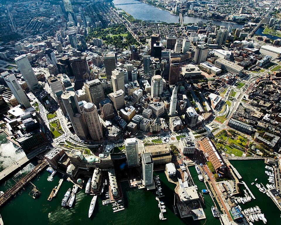
Rose Kennedy Greenway CC-BY-SA-3.0
Aerial images are often used in geography to study natural and human features
Interpretation of aerial images requires both a description and explanation
Identify physical features
Identify natural landscapes:
Rivers (winding shapes, valleys)
Hills or mountains (shadows, contours of land)
Coastlines, beaches, cliffs
Forests, fields, lakes
Recognise human features
Identify human-made structures:
Buildings (rectangular blocks)
Roads and motorways (long, straight or curved lines)
Railways, bridges
Settlements (look at layout – grid, scattered, linear)
Farmland (fields with boundaries)
Describe layout and patterns
Description should include information on:
Distribution (e.g. “Houses are clustered along the road”)
Shape and pattern (e.g. “Fields are regular and rectangular, showing planned farming”)
Land use (e.g. commercial, residential, industrial)
Use direction and location
Refer to compass directions (N, S, E, W).
Use the foreground, middle ground, and background if describing an oblique image
Analyse
Suggest reasons for what you see:
“The settlement is near the river, possibly for water supply or transport.”
“The fields are large and open, suggesting arable farming.”
Examiner Tips and Tricks
When interpreting aerial images:
Be specific: Don’t just say, “there are buildings” – say what type, how many, and where.
Use geographical terms like 'urban area', “'coniferous woodland”, and “meandering river”.
Compare and describe: Look for contrasts (e.g. rural vs. urban areas).
Link to context: If the question is about tourism, industry, or development, relate what you see to the topic.
Field sketches
Field sketches should include:
title
location/site number
compass direction
key features found at a site
Strengths | Limitations |
|---|---|
|
|
Examiner Tips and Tricks
The exam may ask you to sketch and label key features from a photograph. We do not assess total accuracy or artistic prowess; however, you must identify important features such as rivers, coastlines, hills, etc.
Follow the geographical rules for sketching:
Draw a box to frame the sketch
Always draw in pencil
Use colour to highlight a feature
Use a ruler for straight lines and arrows
The arrows always go to the feature, not the label
Never cross arrow lines
Write horizontally to the arrow in pen
Worked Example
The photograph below shows a feature of a river in its upper course.

Identify the landform in the photograph [1 mark]
Sketch and label the key features of this landform [4 marks]
Answer:
Waterfall and gorge [1]

[4]

You've read 0 of your 5 free revision notes this week
Unlock more, it's free!
Did this page help you?
