Predicted impacts of climate change on the coast (WJEC Eduqas GCSE Geography B): Revision Note
Exam code: C112

Specification links
The notes on this page cover part 2.1.4 of the WJEC Eduqas B specification.
2.1.4 - What are the predicted impacts of climate change on coastal landscapes and communities?
The potential impacts of climate change on coastal communities in at least two countries at different levels of development.
Management challenges which arise from sea level rise and the increased frequency of storms.
General effects of climate change on coasts
As global sea temperatures increase, water levels rise through melting ice caps and seawater expansion
A warmer atmosphere leads to more intense and frequent storms, creating powerful, destructive waves
A warm atmosphere can hold more water vapour, which will lead to the following:
Higher levels of precipitation and increased rates of weathering and erosion
Increased cliff instability, leading to greater levels of landslips and falls
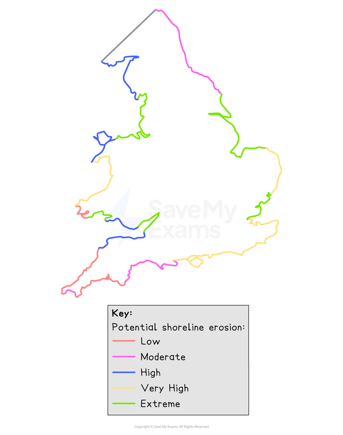
Climate change can impact the whole of the world's coastline, particularly those areas where the cliffs are made from softer rock and clay or are lying close to sea level and can, therefore, flood
Of the 10 world's largest cities, 8 are in coastal areas
Mumbai, home to 18.4 million people, is only 10 metres above sea level
Other cities like New York, Singapore and New Orleans are also at risk
It is estimated that by 2030, 950 million people around the world will live in low-elevation coastal zones (LECZ)
LECZs are often densely populated due to:
Attractive scenery and beaches
Deltas are fertile and ideal for agriculture
Suitable for ports and trade
Countries and regions which are particularly low-lying include:
Bangladesh – over 10% of the land is 1 m or less above sea level
Netherlands - 27% of the country is below sea level and protected by sea defences
Most affected coastal communities are those living on the world's major river deltas, such as
Bangladesh, Egypt, Nigeria, Vietnam and Cambodia
Small island developing states (SIDS) such as Kiribati, Tuvalu and the Maldives are very low-lying
The Maldives has an average height of 2 m above sea level, with the highest point being 2.4 m
Just a 1-metre rise in sea level would flood up to 75% of the land in each of these nations
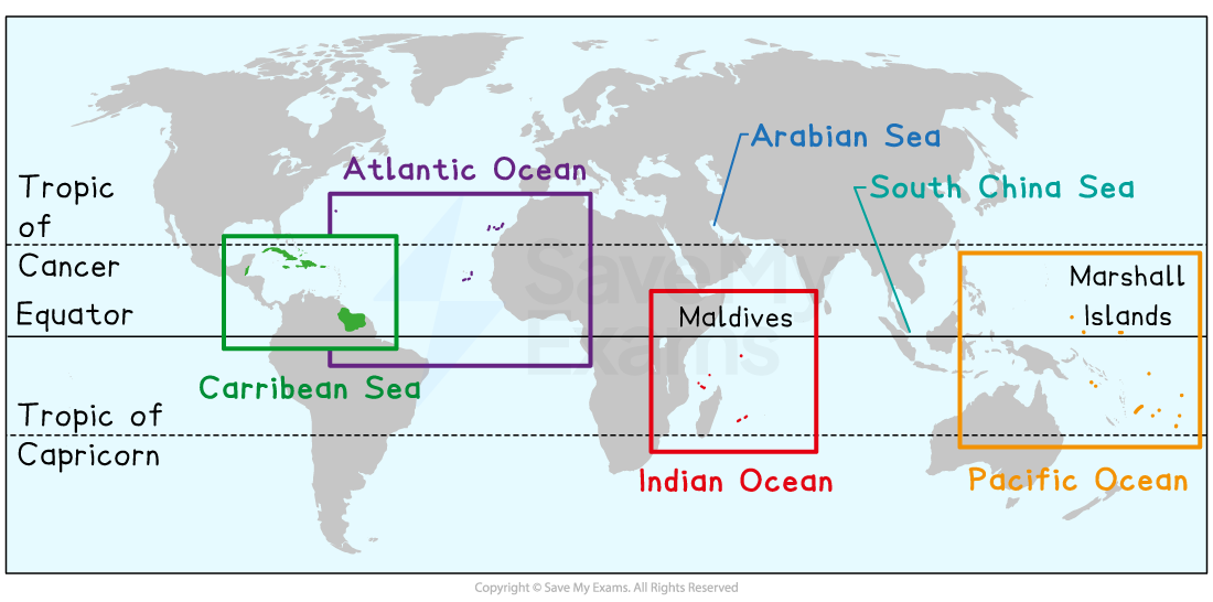
Currently, 65 million people represent 58 SIDS
Many SIDS are small, remote and isolated regions
The standard of living ranges from US$51,000 in Singapore to US$830 in Comoros
Many at-risk cities are in developing countries
Poor neighbourhoods are often in low-lying areas
Beside waterways or seafronts that are prone to flooding
Sea level rise may force some people to become environmental refugees
Reasons for vulnerability to coastal erosion and flooding
There are many reasons why some communities are more vulnerable than others
These reasons can be divided into
Physical
Social
Economic
The image below explains these reasons in more detail
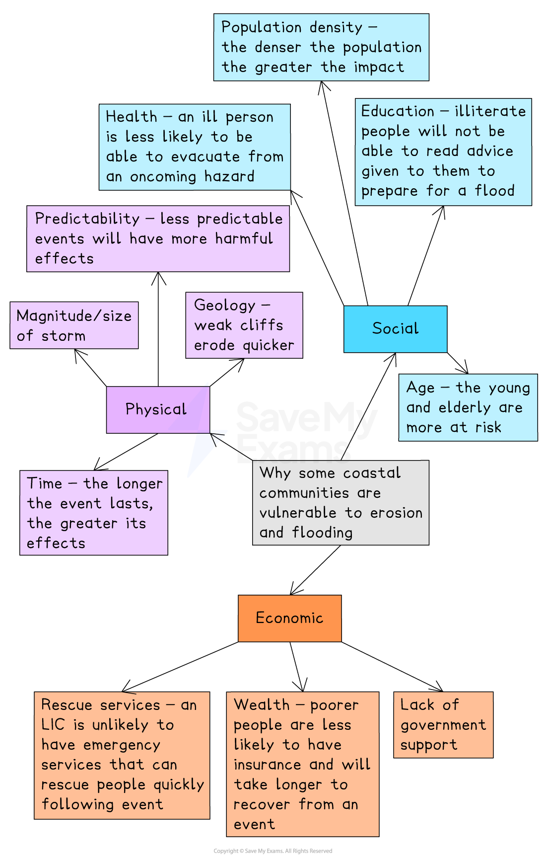
Examiner Tips and Tricks
When discussing the impacts, reasons, or effects of a topic, remember to split it into physical, economic, and social categories. Furthermore, remember that 'social aspects' refers to the effects on people themselves.
Case study: climate change and the Maldives
Location and background
The Republic of Maldives is an archipelago of around 1,192 coral islands grouped in 26 atolls, located in the Indian Ocean, southwest of India and Sri Lanka
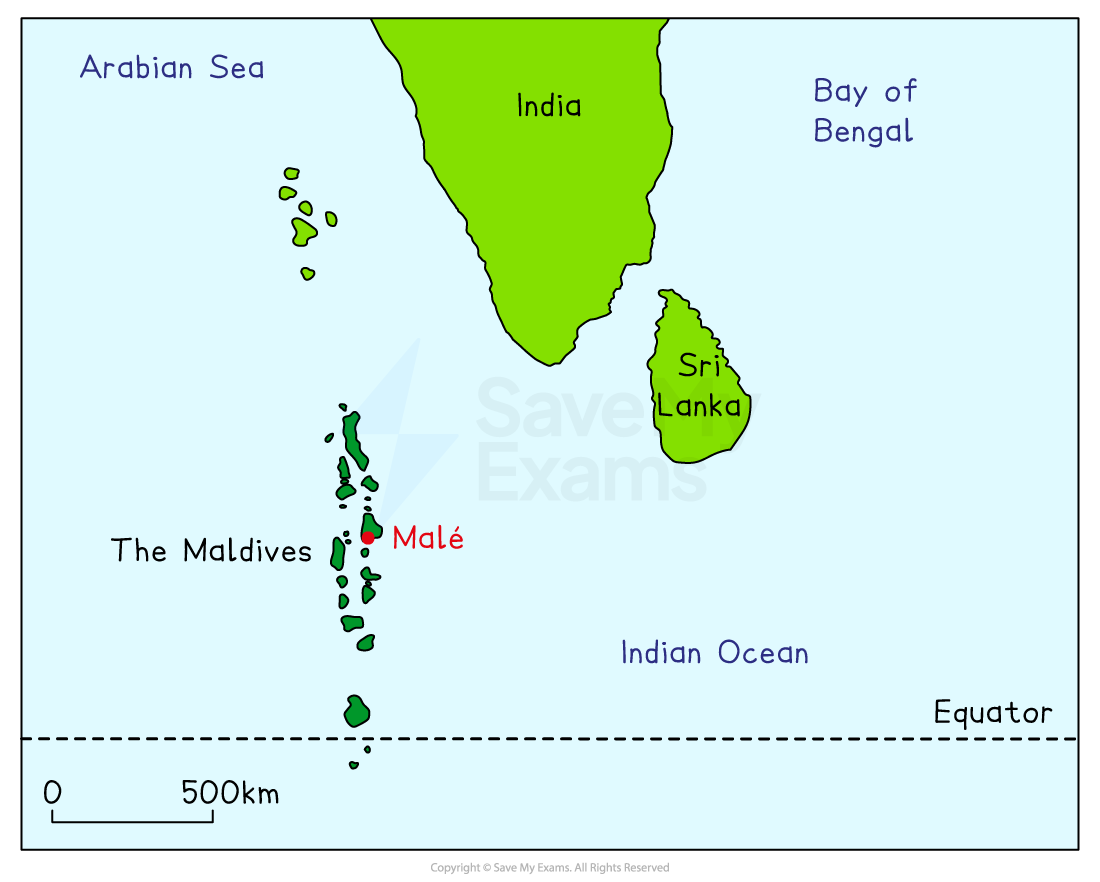
It is the lowest country in the world — the average ground level is just 1.5 metres above sea level
The population is approximately 527,799 people (as of 2024)
The Maldives is a MIC with a Gross National Income (GNI) per capita of $11,070 in 2023
The Maldives has a tropical climate with:
Warm temperatures
Large number of sunshine hours
Little seasonal variation
High humidity year-round
Problems facing the Maldives
The challenges facing the Maldives include
Coastal erosion
Freshwater scarcity
Infrastructure damage
Population displacement
Adaptation strategies that balance socio-economic needs with environmental protection
Coastal erosion
Coral reefs, which act as storm buffers, are damaged by ocean warming and pollution, weakening their natural protection
Without the protection of coral reefs, coastal erosion has severe consequences for the integrity of the shoreline, infrastructure, and local industries like fishing and tourism
Over the last 30 years, frequent flooding of the islands has caused ongoing problems for the Maldives
The majority of issues arise when storms in the northern Indian Ocean coincide with the highest spring tides
More intense tropical storms cause greater damage to homes and flood the coastline with tropical storm-fuelled storm surges
Freshwater scarcity
As the sea levels rise, it puts pressure on already scarce freshwater resources, making it harder to obtain drinking water
More than 90% of the islands in the Maldives have experienced saltwater ingress, with 97% of the country no longer having access to fresh groundwater
This has forced 77% of Maldivians to rely on rainwater for their drinking supply
Importing water from other countries is not a sustainable solution
The Maldivian government, with support of the United Nations Development Programme (UNDP) and Adaptation Fund, has allocated $8.9 million in government funds for an Integrated Water Resources Management (IWRM) program
This aims to improve access to clean water and boost the water supply system's capacity
Infrastructure damage
The government is relying on hard engineering to hold the line against rising sea levels
However, these methods are expensive and have negative impacts, such as increasing erosion elsewhere
Malé, the capital, is surrounded by a 3-meter sea wall that took 14 years to construct and cost $63 million
Japan paid 99% of the cost for this sea defence, as the Maldives was unable to pay for this
The sea wall needs constant repair, and the cost is met through local tourist taxes
The remaining islands are still under threat of flooding
The tourism business is also at risk
Travel and tourism is the Maldives' most important industry—it brings in 90% of the country's revenue
The 2004 Indian Ocean tsunami severely impacted the Maldives, causing widespread damage to infrastructure and devastating the tourism and fishing industries
The country rapidly began to rebuild, and by early 2005, many resorts were operational, with governments urging tourists to return to aid recovery
However, the Maldives remains vulnerable to tsunamis from nearby or distant earthquakes
Climate refugees
A climate refugee is a person who must leave their home and community because of the effects of climate change and global warming
Climate refugees belong to a larger group of migrants known as environmental refugees
The IPCC has predicted that the Maldives will be uninhabitable by 2100, due to sea levels rising by 9 mm/year
Fourteen islands have already had to be abandoned due to intense coastal erosion and natural disasters
Many more islanders will have to abandon their homes, losing their livelihoods and way of life, as well as their culture
Adaptation
A completely new island has been created by dredging sand from nearby lagoons
Called Hulhumalé, it means ‘New Malé’, but it is also called the City of Hope
When the second phase of development is finished, the 2-metre-high island will cover 420 hectares and house 160,000 people, mainly in large blocks of social housing
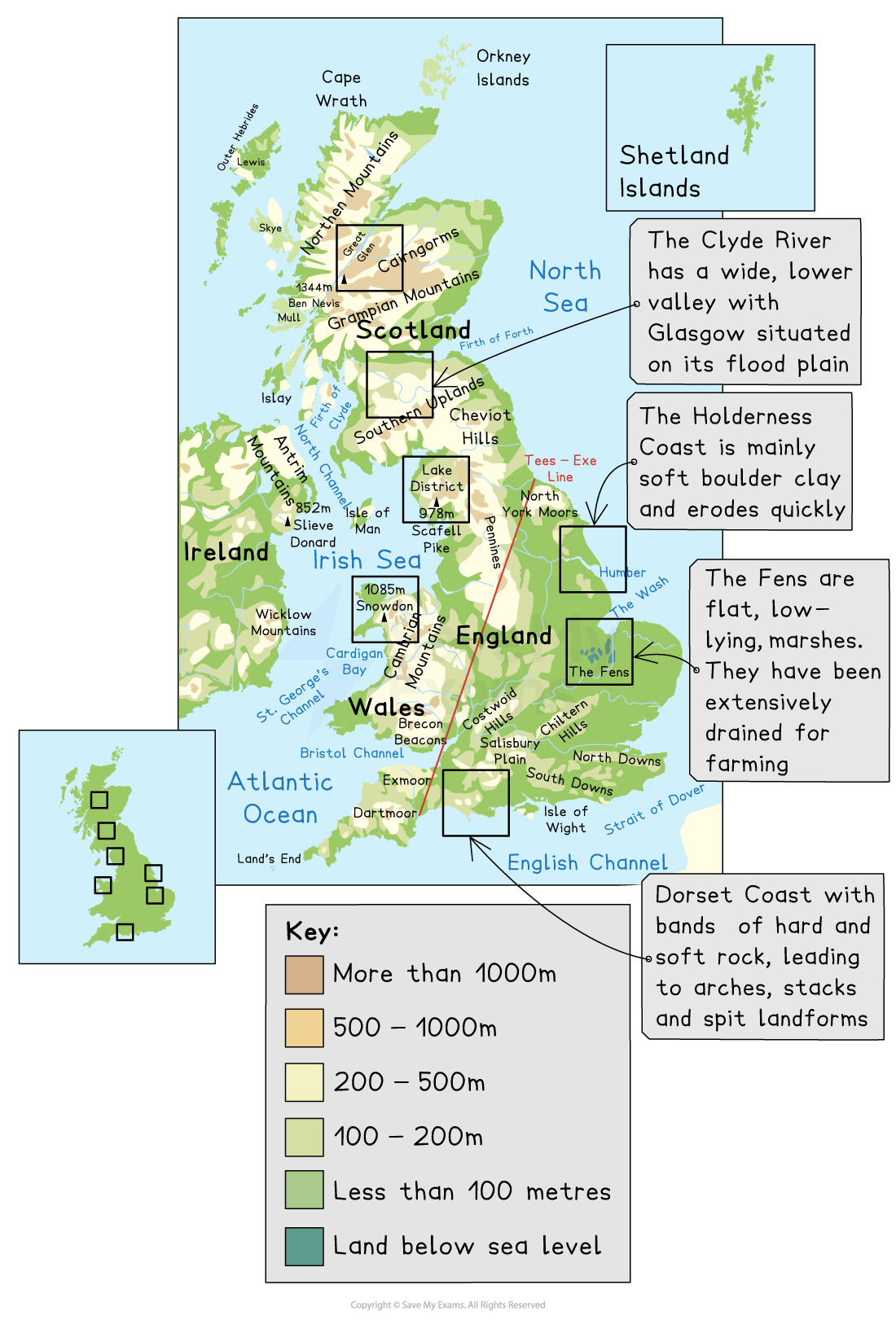
Case study: climate change and the UK
Location and background
The UK is an island country located off the northwest coast of mainland Europe, surrounded by the Atlantic Ocean, the North Sea, and the English Channel
The UK's long coastline is accessible to its population
Fishing, ports, and offshore energy generation are just a few of the key economic activities that take place along the UK coast
Many coastal communities have to deal with
An ageing population and retirees
Young people leaving the area
A percentage of people on benefits
Inward and outward migration
Physical isolation, poor housing, relying too heavily on tourism, seasonal jobs, low income, and pressure on services in the summer
Problems facing the UK
By 2080, climate change will pose a significant risk to UK coastal communities, including increased coastal flooding and erosion due to sea-level rise and more intense storms
These impacts threaten homes, infrastructure (such as power stations, roads, and sewage works), and sensitive coastal habitats like salt marshes and dunes
The UK's original defences are ageing, and there are insufficient funds to upgrade them against the increased frequency and strength of storms
The North Sea is famous for its winter storms, and they often create storm surges that affect communities along the east coast of the UK
These storm surges can be 2 m above normal sea level and can wash over coastal defences and move inland, flooding coastal communities
The Holderness Coast
The Holderness Coastline is located on the East Coast of Yorkshire and runs for 61 km
It stretches from Flamborough Head in the north down to Spurn Head, where it meets the Humber Estuary in the south
It is the fastest-eroding coastline in Europe at 2 m per year
It is made of soft boulder clay and chalk
The coastline has naturally narrow beaches, which give less protection from erosion, as wave power is not reduced
Longshore drift is the dominant process due to the North Sea waves
Waves along the coastline have a long fetch (travel long distances), which increases wave energy
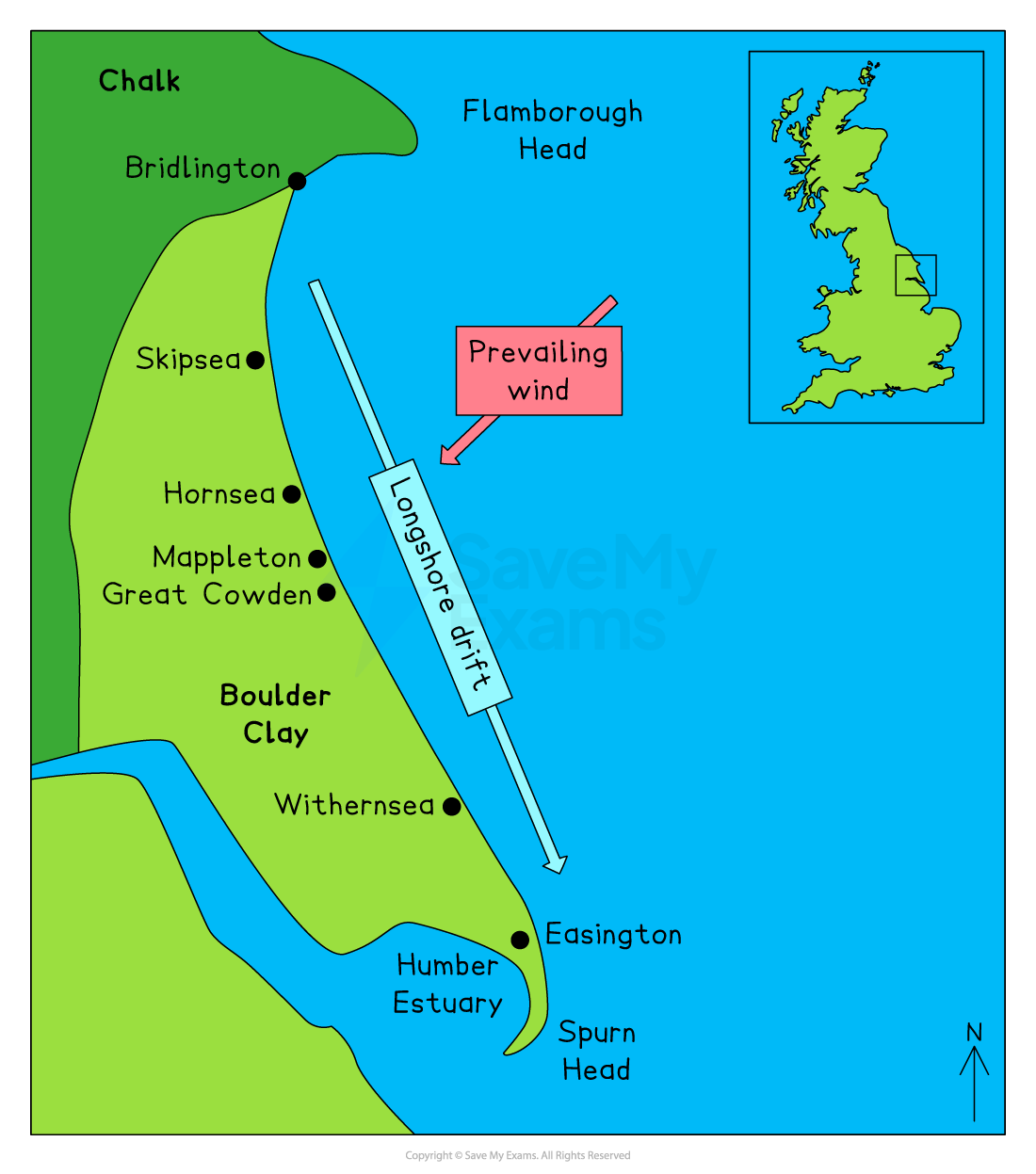
The biggest issue with the Holderness coastline is that it is retreating too quickly
Management of the Holderness Coast
Bridlington is protected by a 4.7 km-long sea wall
Gabions have been built at Skipsea
Hornsea's cliffs are formed from soft boulder clay
As a popular tourist destination, management is aimed at protecting hotels and arcades and creating a sandy beach
Hornsea has spent money on repairing its wooden groynes at a cost of £5.2 million
It also has a concrete seawall
Recently, a stone and steel gabion, along with a concrete revetment, has been built south of Hornsea, helping to protect the caravan park
Riprap, at a cost of £2 million, and groynes and beach nourishment at Mappleton have produced a sandy beach and protect the town
Withernsea has a sea wall, groynes, riprap and beach nourishment to widen the beach and reduce wave energy
Approximately 2.25% of all UK gas comes through the gas terminal at Easington, and £4.5 million was spent on riprap, but the scheme protects the terminal and not the village
Spurn Head is protected with groynes and rock armour
Conflicts
Careful management of coastal regions is necessary to ensure sustainability
Conflict arises when coastal development is seen as being given a higher priority than overall coastal conservation
Management along the Holderness Coast has been successful in part, with the village of Mappleton and the B1242 road no longer at risk from erosion
Due to the use of groynes at Mappleton, sediment has been prevented from moving south, which has increased erosion at Great Cowden
Erosion has destroyed farms, along with the loss of 100 chalets at the Golden Sands Holiday Park
Locals have disagreed about where sea defences are located, especially if community land is not protected
Some sea defences negatively impact tourism and reduce the amount of money coming into the area
Spurn Head is at risk of losing habitats due to a lack of sediment to maintain the spit
Overall, maintaining coastal defences is expensive and the cost may be too great to continue defending an area that is eroding quickly and will continue to erode
London and the Thames Gateway
The River Thames estuary, located to the east of London, is at risk from storm surges
This area, known as the Thames Gateway, is characterised by a narrow, funnel-shaped coastline between Essex and Kent
During storms, this shape causes the sea to be pushed up the Thames towards London
Additionally, the coastline has been gradually sinking since the end of the last ice age in the UK, which was about 10,000 years ago
This process is known as postglacial rebound, where the land slowly adjusts after the weight of ice has melted away
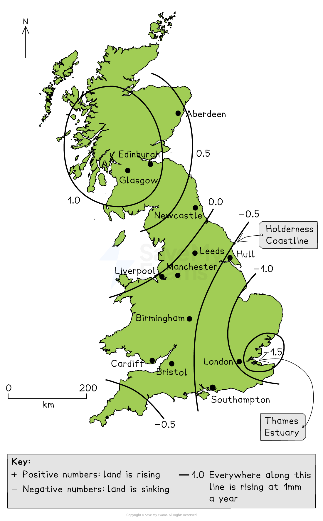
The Thames Gateway is slowly sinking at about 2 mm a year compared to the current sea levels
At the same time, climate change is causing the sea levels in the Thames Estuary to rise by approximately 3 mm each year
So the combined effect of sea level rise and postglacial rebound means that sea levels in this area are rising by about 5 to 6 mm per year
Holding the Thames Estuary line
Situated to the east of the City of London, the Thames Flood Barrier was completed in 1982 and protects 125 million people from tidal surges coming up the river from the North Sea
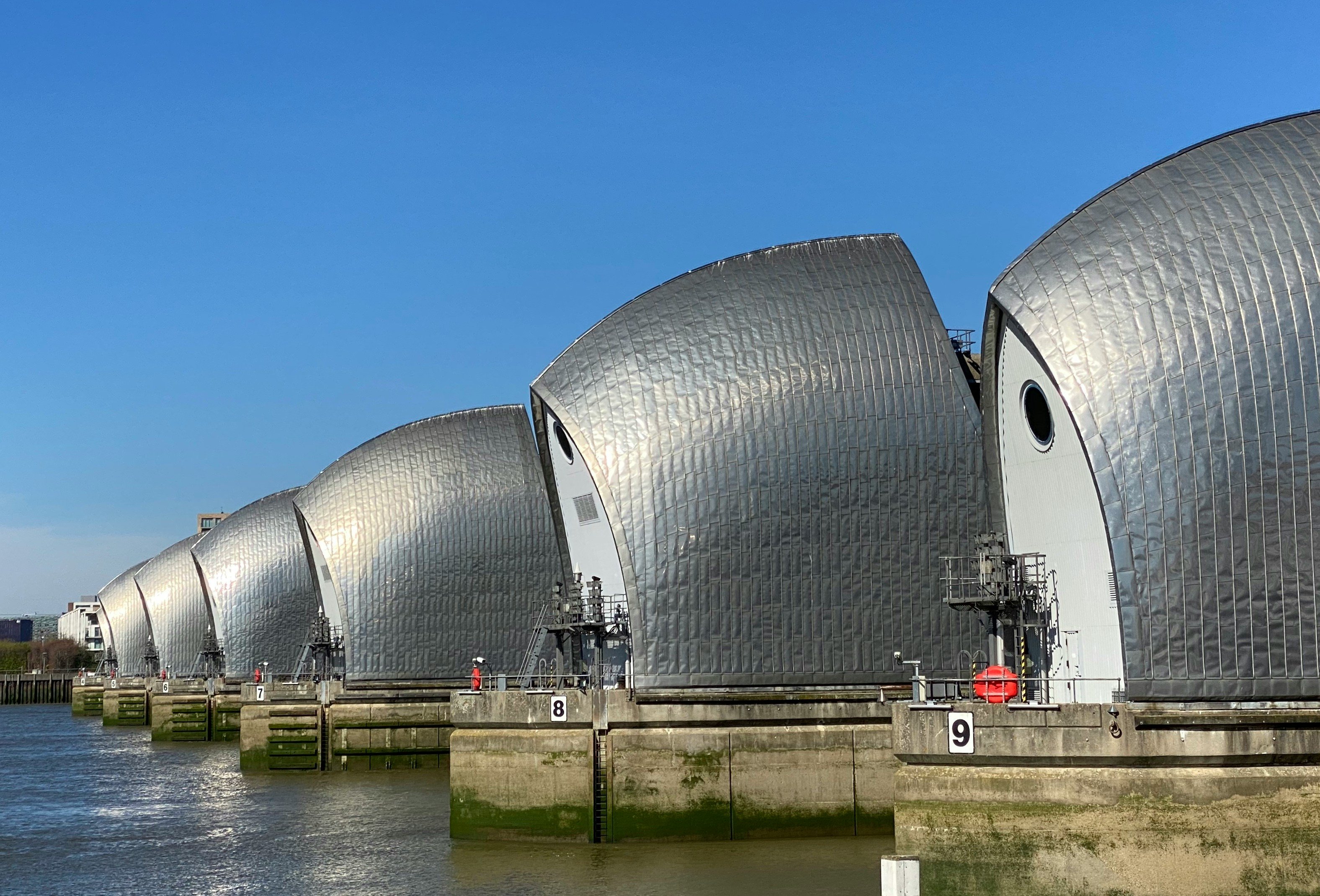
Thames Barrier. Photo by John Cameron on Unsplash Since it opened, it has been closed 221 times to protect London
However, with a warming climate and higher sea levels, it's being used more often and the barrier may not be big enough to protect London from future storm surges
The Thames Estuary 2100 Plan (TE2100) highlighted that London needs to future-proof against 2.7 m + current levels of flooding.
The TE2100 Plan has 3 management strategies
Continue to renew and replace existing embankments, sea walls and sluices in the Thames Gateway
Increase the amount of inter-tidal habitat by 876 hectares, helping to store floodwater as it moves up the estuary during a tidal surge
Consider building a new, larger barrier at Long Reach to the east of the existing barrier; the cost of this construction would be between £6 and £7 billion
The UK government will decide on the options by 2040
Worked Example
Give four impacts that sea-level rise would have on coastal communities in the UK.
[4 marks]
Answer
Loss of homes from cliff erosion. [1 mark]
Homes would experience increased flooding. [1 mark]
Damage would occur to infrastructure, which includes power stations, roads, and sewage works. [1 mark]
Flood coastal habitats like saltmarshes and dunes. [1 mark]
Marking guidance
The question asks you to 'give' four impacts. This means you need to state the final result, not the reason, as that would be an 'explain' question.
1 mark per valid response

Unlock more, it's free!
Join the 100,000+ Students that ❤️ Save My Exams
the (exam) results speak for themselves:

Was this revision note helpful?
