Factors affecting water in river landscapes (WJEC Eduqas GCSE Geography B): Revision Note
Exam code: C112

Specification Link
The notes on this page cover part 2.2. 1 of the WJEC Eduqas GCSE B Geography.
2.2.1 - How do people and processes contribute to the development of distinctive river landscapes in the UK?
At a wider scale, ways in which climate, geology and human activity influence flows and stores of water within river landscapes.
Coverage to include:
The processes of interception, transpiration, infiltration, surface run-off and throughflow.
How these may be affected by human activity through changes to vegetation and urbanisation.
How climate creates seasonal variation in discharge.
The concept of an annual regime.
The use of hydrographs to show the relationship between climate and discharge
Drainage basin processes
A drainage basin is the area of land drained by a river and its tributaries
This is also known as the catchment area of the river
Drainage basins are open systems
As well as stores and transfers, drainage basins have inputs and outputs
Inputs include any water entering the system (precipitation)
Outputs are where water is lost from the drainage basin (evaporation, transpiration and into the sea/lake)
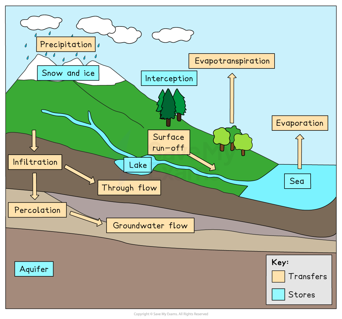
When precipitation falls into the drainage basin, it will take different paths. These include:
Direct channel precipitation, which occurs when the water falls directly into a river
Surface run-off occurs when the water cannot infiltrate the surface, soil or rock due to the impermeable surface
Throughflow occurs when the water flows through the soil
Groundwater flow occurs when the water flows through the rocks
Every drainage basin is unique, as they all have different shapes and sizes and contain different:
Rock types (permeable or impermeable)
Relief
Land uses (urban or rural)
Types and amount of vegetation
Geology and drainage basins
Permeable rocks increase infiltration and percolation, which reduces surface run-off
Impermeable rock decreases infiltration and percolation; this increases surface run-off
The impact of human activity on flows and stores of water
Human activity within the drainage basin can have a significant impact on the flows and stores of water
Human activities include:
Deforestation
Afforestation
River management
Urbanisation
Agriculture
All of these impact on the natural processes and regime of rivers
Deforestation
Lack of trees and other vegetation reduces interception and infiltration, increasing surface run-off
Afforestation
An increased amount of trees increases interception and infiltration, reducing surface run-off
River management
Dams can be used to control the level of discharge downstream; this affects the river regime as it becomes more consistent with fewer peaks and troughs
This reduces the flood risk downstream
There may also be a reduction in the amount of erosion downstream due to more consistent discharge
Reservoirs are human-made water stores which cause the water velocity to slow in the reservoir, leading to increased deposition
The dams also trap sediment, which can impact the amount of deposition downstream
Abstraction
Abstraction is when water is taken from a store within the drainage basin
Humans abstract water from surface stores and groundwater stores
Groundwater stores are also known as aquifers
These are areas of porous rock, such as chalk or sandstone
When water is taken from the stores more quickly than it is replaced (recharged), it is known as over-abstraction
This reduces the level of water stores
Urbanisation
Impermeable concrete and tarmac increase surface run-off
Agriculture
Bare soil and ploughing increase surface run-off, especially where ploughing is downslope
Replacement of pasture (grassland) with arable crops also increases surface run-off
Climate change
Rising global temperatures may increase storm frequency and intensity, increasing precipitation, which increases surface run-off
Increasing drought, which leads to baked soil and periods of extreme cold, which freeze the soil, which means that water cannot infiltrate and there is increased surface run-off
Influence of climate on river discharge
The UK has a temperate climate, but there is a wide variation across the country, which means:
Some areas, such as the north and west, experience more rainfall
The south and east have lower rainfall than average
Scotland and the north experience colder temperatures
The South experiences higher temperatures
Precipitation
In areas where precipitation levels are higher, there will be:
Higher discharge levels
Areas of the UK that experience lower than average precipitation will have:
Lower discharge levels
The type of precipitation is also important
In areas with higher levels of snowfall, the higher discharge will be in spring when the snow and ice melt
Temperature
Higher temperatures lead to increased evaporation and transpiration
This reduces the amount of water entering the river and so discharge is lower
Examiner Tips and Tricks
In the exam, you may be expected to explain how human activities or climate change impact natural river processes or discharges. It is important to focus on the changes to the river processes or discharge rather than impacts on the wider river landscape.
River regime and hydrographs
What is a river regime?
The discharge of a river is defined as the amount of water passing a specific point on the river at a given time
Discharge changes over time
The river regime is a record of these changes over a year
The regime of a river is affected by all the characteristics of drainage basins outlined above
Any factor which increases surface run-off increases discharge in the river
Any factor which increases interception, infiltration or abstraction will lead to a slower increase in discharge or a reduction in discharge
What is a hydrograph?
A hydrograph shows the changes in river discharge after a storm event
The graph shows a short period, usually 24 hours
The storm hydrograph has several features:
Base flow, which is the 'normal' level of river discharge
The water mainly comes from groundwater flow
Peak rainfall is the highest rainfall level during the storm
The time of the peak rainfall is taken from the centre of the bar
The rising limb shows the increase in the river discharge
The steeper the limb, the faster the river discharge has increased
Peak discharge or peak flow is the highest level of discharge
Lag time is the time difference between the peak rainfall and the peak discharge
The shorter the lag time, the higher the risk of flooding because the river may not have the capacity to contain the increase in discharge
Where there is more overland flow (surface runoff), the lag time will be shorter
The recessional limb shows the river discharge returning to normal flow
The steeper the recessional limb is, the faster the river returns to normal flow

Examiner Tips and Tricks
Remember, a hydrograph shows the changes in discharge over a short period after a storm event, whereas the river regime shows changes in discharge over a long period, usually a year.

Unlock more, it's free!
Join the 100,000+ Students that ❤️ Save My Exams
the (exam) results speak for themselves:

Was this revision note helpful?
