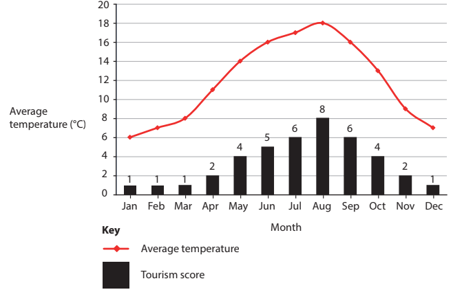
Coastal Management (Edexcel AS Geography): Exam Questions

Exam code: 8GE0

1 hour10 questions
1a
1 mark

Study Figure 6

Graph showing average temperature and tourism score by month. Temperature peaks in July and August, while tourism score is highest in August.

Figure 6
Temperature data and tourism score for Whitehaven, Cumbria

A group of students were planning fieldwork and deciding on the best time to investigate the success of coastal management approaches at Whitehaven in Cumbria.

They consulted a website that showed them a tourism score (calculated from 1–10), which suggested months where the likely number of visitors to the area would be high or low.

Identify the month with the highest temperature.

1b
2 marks

Describe the trend of the tourism score during the year.

1c
2 marks

The students’ investigation focussed on the views of tourists and residents about the visual impact of different approaches to coastal management.

Suggest which month would be the most sensible for these students to complete their fieldwork about differing viewpoints.

1d
4 marks

Explain two factors these students should consider before choosing their fieldwork locations.

2
9 marks

You have carried out an investigation into coastal landscapes and change.

Assess the usefulness of ICT (Information and Communications Technology) to process and present the data and information you have collected.

Geographical enquiry question

3a
1 mark

Study Figures 5a and 5b

Map depicting the Castlerock to Portstewart area, showing the Atlantic Ocean, sandy beaches, sand dunes, grass, towns, and a scale bar.

Figure 5a
Land use at Portstewart Strand, County Londonderry, Northern Ireland

Sandy beach stretching along a coastline with gentle waves, sparse clouds in a blue sky, and several parked cars on the sand near grassy dunes.

Figure 5b
Portstewart Strand, County Londonderry, Northern Ireland

Portstewart Strand is a major coastal attraction in Northern Ireland. It is managed by the National Trust.

The line AB is the distance from the start to the end of Portstewart Strand.

There are different approaches to managing coastal landscapes.

Identify which approach is the most likely to be suitable for Portstewart Strand.

  • Offshore breakwater

  • Dune stabilisation

  • Revetments

  • Sea wall

3b
2 marks

Calculate the length of line AB in Figure 5a.

Show your working.

Give your answer, in kilometres, to 1 decimal place.

..............................................................km

3c
3 marks

Suggest one reason why this landscape has amenity value.

4
6 marks

With reference to one named coastline, explain why policy decisions can lead to conflict between different players.

Named example

5
1 mark

A group of students collected fieldwork data about cliff profiles at 15 different locations along a section of the north Cornwall coastline.

Study Figure 7

Tables showing cliff conditions: 8 locations with sea water, 9 very weathered, 6 cliffs 15–30m high, and other features measured in different categories.

Figure 7
Collated data collection sheets from group fieldwork in an
active coastal landscape in Cornwall

Identify one risk students might have had to consider when carrying out fieldwork in this environment.

6
4 marks

Explain two economic reasons why coastal recession is significant.

7
4 marks

Study Figure 6

Map comparison of Southerndown coast with standard and topographic views. Both highlight Box A, scale bars, orientation, and main road B4524.
Map key showing symbols for roads, water bodies, rocky areas, and study area. Slope angles range from flat (grey) to steep (dark brown).

Figure 6
Geographic Information System (GIS) maps showing slope angle
around Southerndown, Glamorgan Heritage Coast, Wales

A group of students used GIS to find secondary information about the relief of
the Glamorgan Heritage Coast in South Wales in order to help plan their fieldwork investigation into coastal landscapes.

Explain two decisions these students would have to make as part of a risk assessment.

8
16 marks

Study Figure 7a and Figure 7b

Figure 7: Information about Aqaba, Jordan, Middle East.

Bullet points describing the Gulf of Aqaba's geological and economic features, including plate boundaries, coastal plain formation, trade, tourism, and earthquake hazards.
Diagram illustrating coastal management strategies, including land allocation, oil pollution response, marine protection, and beach zone restrictions.

Figure 7a
Management strategies used in Aqaba

Image shows a beach with a few structures; text discusses Aqaba receiving 500,000 visitors annually, resort developments, and environmental impacts on the Gulf of Aqaba.
Map of the Gulf of Aqaba showing zones for tourism, port, marine park, and industry. Includes earthquake epicentres and images of a port and resort.

Figure 7b
Changing coastal landscapes in Gulf of Aqaba

The coastal landscape of Aqaba, Jordan, faces many threats.

Evaluate the effectiveness of the management strategies shown.

9
12 marks

Assess the social and economic risks of rapid coastal retreat.

10a
2 marks

Study Figure 6

Graph showing percentage vegetation cover in managed (blue) and unmanaged (red) areas across a footpath, with symmetrical data distribution.

Figure 6
Kite diagrams showing footpath erosion in two areas
of sand dunes at Studland Bay, Dorset

A group of students collected data about footpath erosion at Studland Bay, a sand dune coastline in Southern England.

They measured vegetation cover across a transect on:

1. a managed footpath

2. an unmanaged footpath.

They presented their findings as two kite diagrams.

Identify two impacts of footpath management.

10b
2 marks

Suggest one reason why footpath management is necessary in sandy coastal landscapes.

10c
4 marks

The students also collected data at ten sites along the unmanaged footpath, measuring width at 30-metre intervals away from the car park, northwards.

They used this data to test the relationship between the width of the footpath and distance from the car park.

Explain how the use of a statistical method would help their investigation about footpath erosion.