1
12 marks
Assess the influence of different stakeholders in managing threats to fragile glaciated landscapes.
Was this exam question helpful?
Exam code: 8GE0
Assess the influence of different stakeholders in managing threats to fragile glaciated landscapes.
Was this exam question helpful?
Study Figure 3
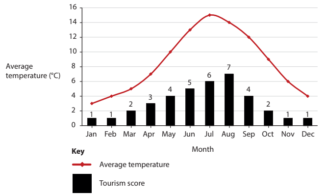
Figure 3
Temperature data and tourism score for Ambleside, Cumbria
A group of students were planning fieldwork and deciding on the best time to investigate the impact of human activity on fragile glaciated landscapes near Ambleside, in the Lake District. They consulted a website that showed them a tourism score (calculated from 1–10), which suggested months where the likely number of visitors to the area would be high or low. |
Identify the month with the highest temperature.
Describe the trend of the tourism score during the year.
Suggest which month would be the most sensible for these students to complete their fieldwork about the impact of human activity.
The students’ investigation focussed on the impacts of human activity on the landscape.
Explain two factors these students should consider before choosing their fieldwork locations.
Was this exam question helpful?
You have carried out an investigation into glaciated landscapes and change.
Assess the usefulness of ICT (Information and Communications Technology) to process and present the data and information you have collected.
Geographical enquiry question
Was this exam question helpful?
Study Figures 2a and 2b
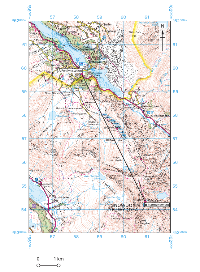
Figure 2a
OS map of the area around Yr Wyddfa (Snowdon), North Wales
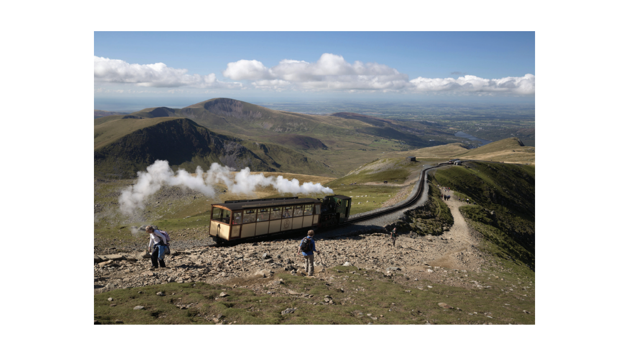
Figure 2b
Snowdon Mountain Railway
The Snowdon Mountain Railway is a major tourist attraction in Snowdonia, a National Park in Wales. Snowdonia is a relict glaciated landscape.
There are different approaches to managing glaciated landscapes.
Identify which approach is the most likely to have been taken here.
Multiple economic uses
Total exploitation
Total protection
Global legislative framework
The line AB is the distance between the start and the end of the Snowdon Mountain Railway.
Calculate the length of line AB in Figure 2a.
Show your working.
Give your answer, in kilometres, to 1 decimal place.
..............................................................km
Suggest one reason why this landscape might have value.
Was this exam question helpful?
Using one named example, explain why management approaches in glaciated landscapes can lead to conflict between stakeholders.
Named example
Was this exam question helpful?
Study Figures 3a, 3b, 3c and 3d
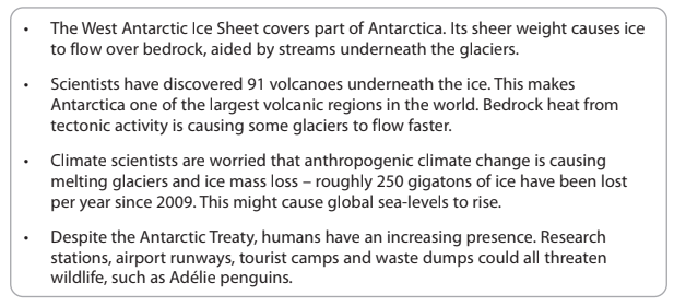
Figure 3a
Information about the West Antarctic Ice Sheet, Antarctica
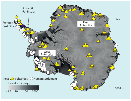
Figure 3b
Map of Antarctica showing ice flow velocity, together with
location of volcanoes and human settlement
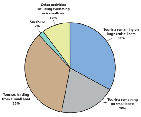
Figure 3c
Tourist activity in Antarctica during 2016–17
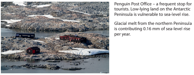
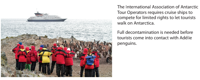
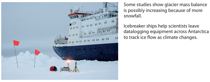
Figure 3d
Three scenes from the West Antarctic Ice Sheet
Evaluate the view that people are the main threat to Antarctica’s glacial landscape.
Was this exam question helpful?
Study Figure 6
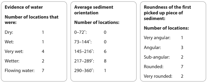
Figure 6
Collated data collection sheets from group fieldwork in an active
fluvioglacial landscape in the Swiss Alps
A group of students collected fieldwork data at 15 different locations in a fluvioglacial landscape in the Swiss Alps.
Identify one risk students might have had to consider when carrying out fieldwork in this environment.
Was this exam question helpful?
Explain two economic reasons why glaciated landscapes are important.
Was this exam question helpful?
Study Figure 3
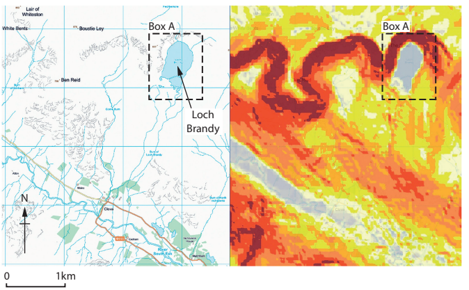
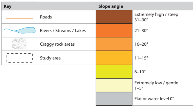
Figure 3
Geographic Information System (GIS) maps showing slope angle
around Glen Clova valley, Cairngorms National Park, Scotland
A group of students used GIS to find secondary information to help plan their primary fieldwork investigation into glaciated landscapes in the Cairngorms National Park.
Explain two decisions these students would have to make as part of a risk assessment.
Was this exam question helpful?
Study Figure 4a and Figure 4b
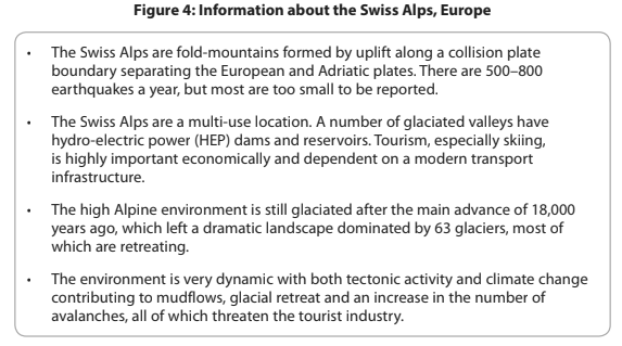
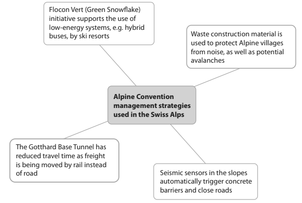
Figure 4a
Management strategies used in the Swiss Alps
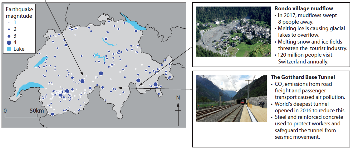
Figure 4b
Threats to Swiss Alpine landscapes
The Swiss Alps glaciated landscape faces many threats.
Evaluate the effectiveness of the management strategies shown.
Was this exam question helpful?
Assess the threats to the economic and environmental value of glacial landscapes.
Was this exam question helpful?
Study Figure 3
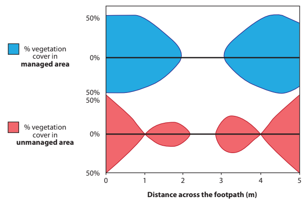
Figure 3
Kite diagrams showing footpath erosion in two areas
near Easedale Tarn, Lake District
A group of students collected data about footpath erosion near Easedale Tarn, a fragile, glaciated landscape in the Lake District.
They measured vegetation cover across a transect on:
1. a managed footpath
2. an unmanaged footpath.
They presented their findings as two kite diagrams.
Identify two impacts of footpath management.
Suggest one reason why footpath management is necessary in this fragile glaciated landscape.
The students also collected data at ten sites along the unmanaged footpath, measuring width at 250-metre intervals away from the car park up a slope.
They used this data to test the relationship between the width of the footpath and distance from the car park.
Explain how the use of a statistical method would help their investigation about footpath erosion.
Was this exam question helpful?