Case Study of a UK City: London (Edexcel GCSE Geography A): Exam Questions

Exam code: 1GA0

41 mins10 questions
11 mark

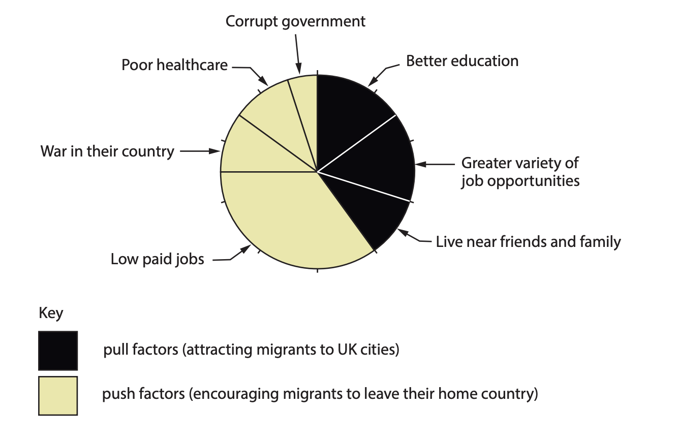
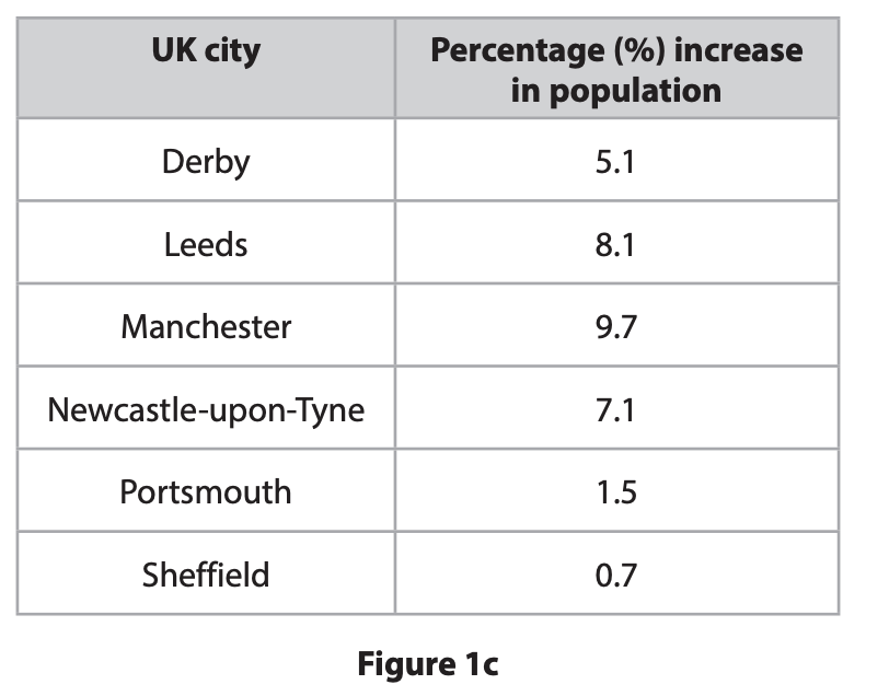
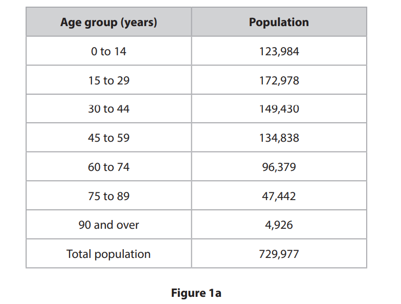
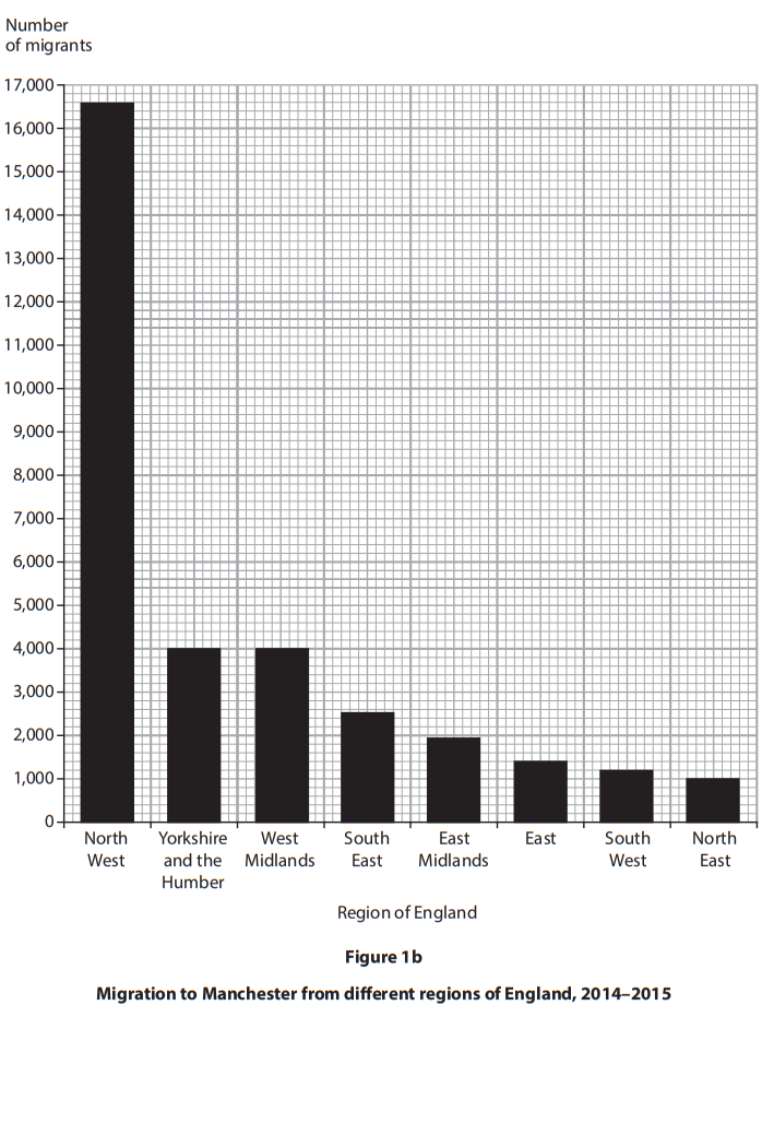
UK cities are changing due to the movements of people, employment and services.

Identify the term which is, “the movement of people back into urban areas where populations had previously declined”

  • suburbanisation

  • counter-urbanisation

  • international migration

  • re-urbanisation

2a3 marks
Results from a survey completed by a sample of 
international migrants who have moved to UK cities
Results from a survey completed by a sample of international migrants who have moved to UK cities

Study Figure 1b in the Resource Booklet.

Describe the results of the survey shown in Figure 1b.

Use data in your answer.

2b2 marks

Explain one positive impact of migration on cities.

3a2 marks
Percentage increase in population in selected UK cities, 2011–2021

Study Figure 1c in the Resource Booklet.

Calculate the median percentage increase in population shown on Figure 1c.

Write your answer to one decimal place.

You must show your working in the space below

............................... %

3b2 marks

In Wolverhampton, another UK city, there was a population increase from 249,500 in 2011 to 263,700 in 2021.

Calculate the percentage increase in the population of Wolverhampton between 2011 and 2021.

Write your answer to one decimal place.

You must show your working in the space below.

44 marks

Explain two reasons why deindustrialisation has taken place in some UK cities

52 marks

The causes and effects of urbanisation can vary between countries at different levels of development.

Explain one reason why suburbanisation has taken place in the UK.

68 marks

You have studied a major UK city.

Assess the impacts of recent changes in retailing on this city. (8)

Named UK city

7a1 mark

The city of St Albans is influenced by its site, situation and connectivity.

Study the Ordnance Survey (OS) map (opens in a new tab) extract Map.

Which one of the following grid squares does the A1081 main road pass through?

  • 1707

  • 1506

  • 1808

  • 1206

7b1 mark

Name the two suburbs of St Albans located in the following grid squares.

1508_______________________________________________________

1405_______________________________________________________

7c3 marks

Suggest one reason why the area in grid square 1407 became the original site of St Albans.

7d3 marks

Compare the land use in grid square 1409 with grid square 1505.

8a1 mark

Study Figure 1a in the Resource Booklet.

2011 Census data for Nottingham, a UK city

Identify the age group with the largest population.

  • Age 0 to 14

  • Age 15 to 29

  • Age 30 to 44

  • Age 75 to 89

8b2 marks

Calculate the percentage (%) of Nottingham’s population aged 45 to 59 years old.

Give your answer to one decimal place.

You must show your working in the space below.

91 mark

Define the term de-centralisation.

10a2 marks

Study Figure 1b

Migration to Manchester from different regions of England, 2014–2015

Identify the two correct statements about migration to Manchester

  • The same number of migrants came from the West Midlands and the East Midlands.

  • More migrants came from the North West than from the North East and the East Midlands combined.

  • A total of 3,000 migrants came from the West Midlands and the East combined.

  • Fewer migrants came from the South East than the North East.

  • A total of 5,000 people migrated from Yorkshire and the Humber and the North East combined.

10b1 mark

Calculate the range of the number of migrants across all regions shown in Figure 1b.

10c2 marks

Explain one impact of migration on housing in a UK city that you have studied. Named UK city