1
2 marks
Give one reason why urbanisation causes flooding.
Was this exam question helpful?
Exam code: C112
Give one reason why urbanisation causes flooding.
Was this exam question helpful?
The town of Slough has suffered from river flooding many times in recent years.
Study Figure 2.2 and the OS Map (opens in a new tab)
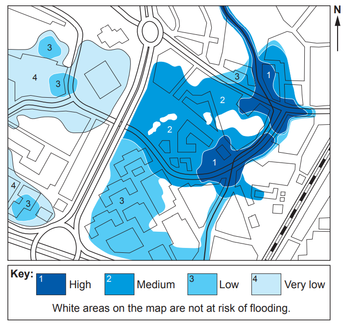
Use the information in both Figure 2.2 and the OS Map to decide if each of the following statements are True or False.
True (T) / False (F) | |
The Academy at 965794 is in a high flood risk zone. | |
The hotel at 962797 is not at risk of flooding. | |
The greatest risk of flooding is in the west of Area A. | |
The houses at 963793 are at a lower risk of flooding than those at 967796. |
Was this exam question helpful?
Study Figure 2.3.
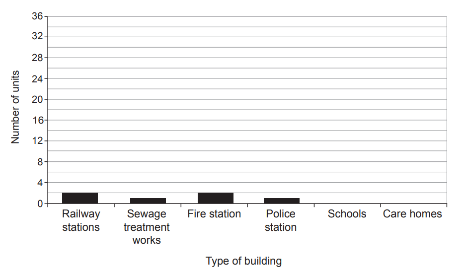
Complete Figure 2.3 by drawing bars to show the following data for care homes and schools.
Number of buildings | |
Schools | 35 |
Care homes | 2 |
Suggest two other appropriate techniques that could be used to display the data in Figure 2.3.
Was this exam question helpful?
Study Figure 2.4.

Suggest why this scheme could be described as a sustainable solution to Slough’s flood problem.
Was this exam question helpful?
Study Area B on the OS Map (opens in a new tab).
Analyse the economic consequences if Area B on the map was to flood. Use map evidence in your answer.
Was this exam question helpful?
More land is being used for towns and cities in the UK.
Explain why using more land for towns and cities might increase the risk of river flooding in the UK.
Hard engineering is one option that is used to manage river flooding.
Explain why hard engineering methods might have limitations when managing flood risk from rivers in the UK
Was this exam question helpful?
Storm Christoph caused widespread flooding in the UK.
Give one reason why heavy rainfall causes flash flooding.
Was this exam question helpful?
Physical processes create distinctive river landscapes in the UK. Study Figure 2.4.
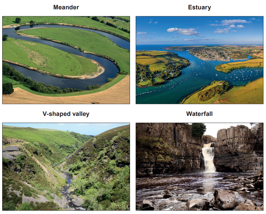
Erosion is the most important physical process in the formation of distinctive river landscapes in the UK, such as those shown in Figure 2.4. How far do you agree?
Was this exam question helpful?
Some rivers in the UK are under increasing risk of flooding.
Study Figure 2.5 below.
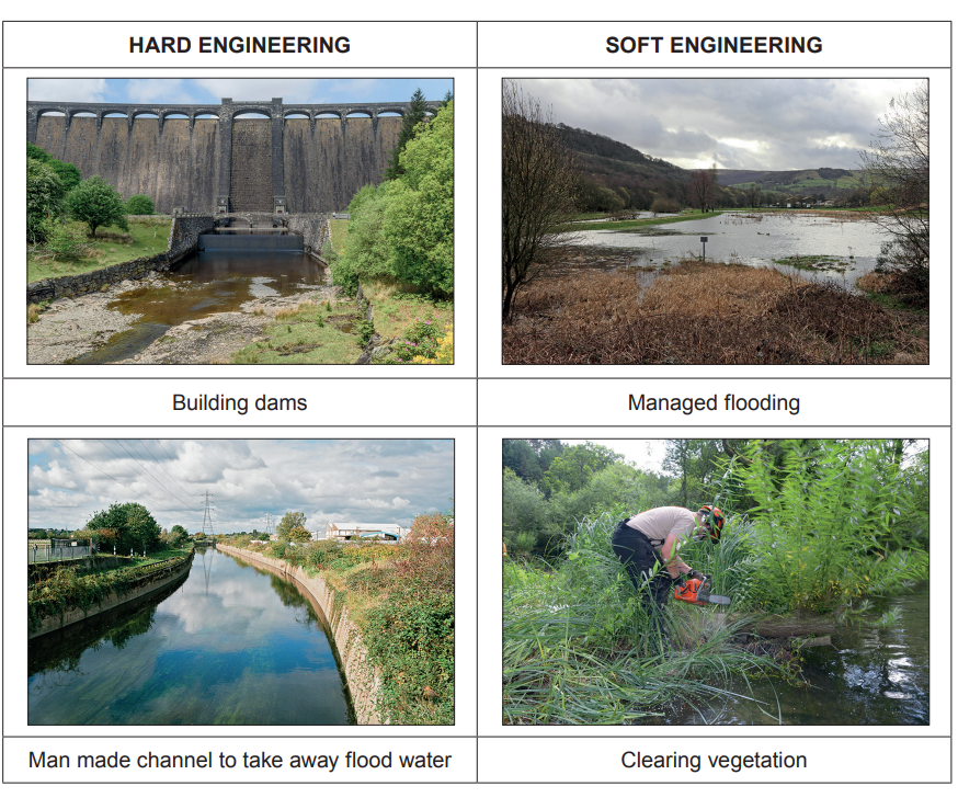
Is hard or soft engineering a more sustainable way of managing UK rivers? Justify your views.
Was this exam question helpful?
Floods can also have impacts on people. Study Figure 2.3.
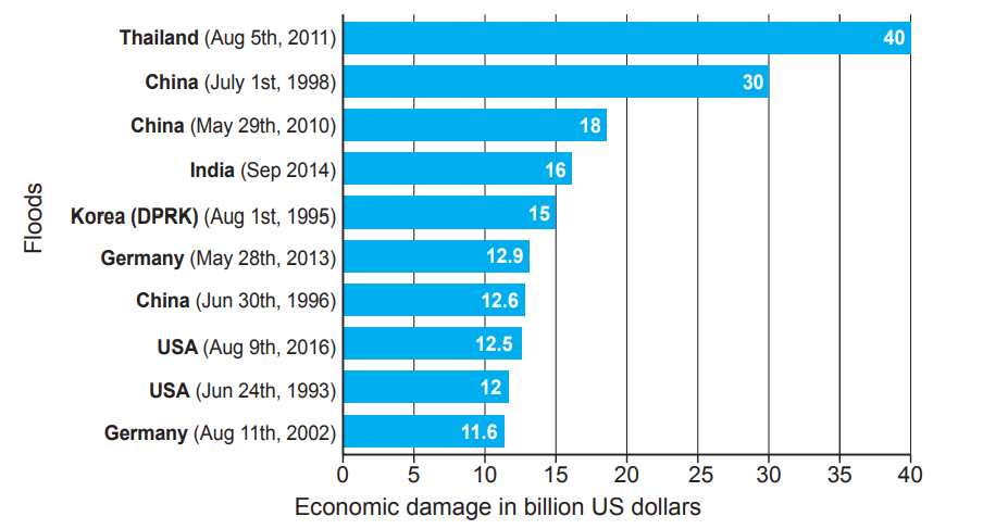
The table below contains four statements about Figure 2.3. Only two are correct. Tick (√) the two correct statements.
Germany had greater total economic damage than the US
China had greater total economic damage than Thailand
There was lower economic damage between 1993 and 1999 than between 2000 and 2016
The most recent flood shown occurred in Germany
Suggest one way in which Figure 2.3 could be improved
Was this exam question helpful?
Study the information in Figure 2.4.
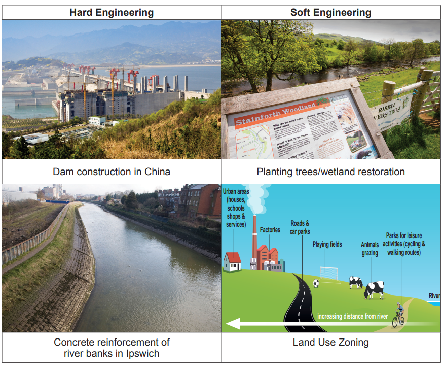
“Soft engineering is a better river flood management strategy than hard engineering”. How far do you agree with this statement? You should consider both sides of the argument in your answer.
Was this exam question helpful?
Study the information in Strategy 1
Strategy 1 – Using underground water stores (aquifers).
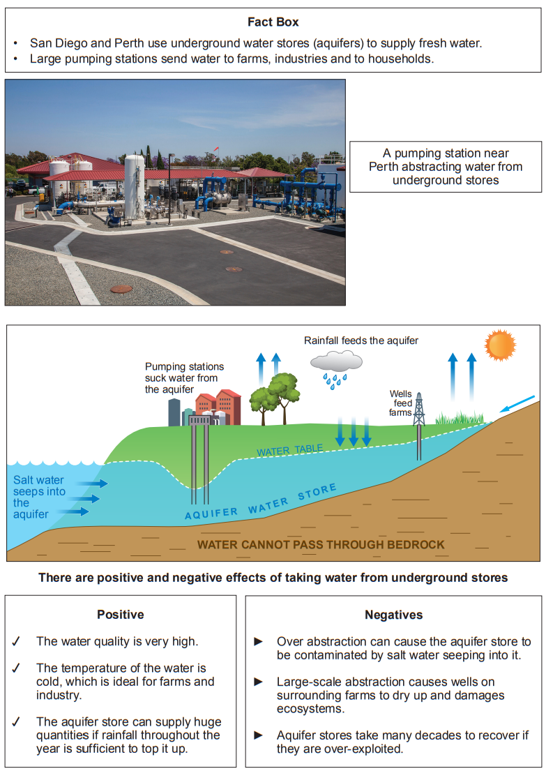
Explain why climate influences stores and flows of water.
Was this exam question helpful?
The students used a website to get data of the house prices in Bewdley. The information is shown on Map 2.2 below.
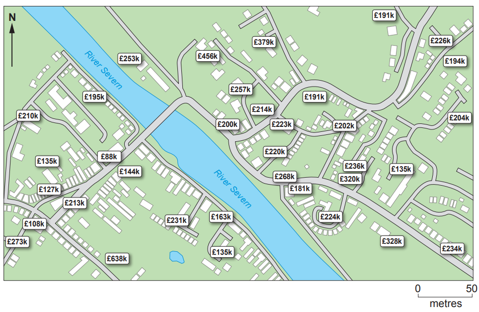
Suggest two reasons why the river can affect house prices.
Was this exam question helpful?
The UK experiences frequent flooding. Give one reason why parts of the UK are at risk of river flooding.
Was this exam question helpful?
Study Diagram 3.3 below. The amount of urban land in the UK is increasing. This creates pressure to use floodplains.
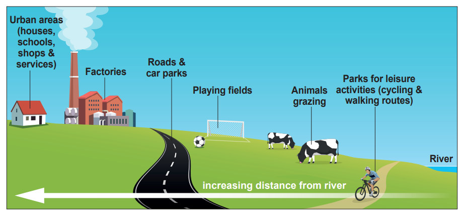
Give two reasons why land use zoning on floodplains is used to reduce flood risk.
Was this exam question helpful?
Keswick in the north of England is an area at high risk of flooding.
Study Photograph 3.4 below which shows a flood management strategy in Keswick.
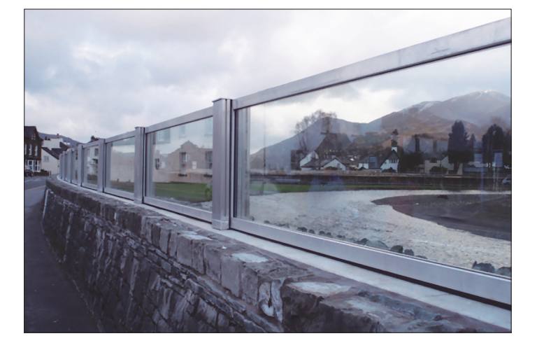
Explain why the choice of different flood management strategies, like the one in Keswick, could cause conflicting views between groups of people?
Was this exam question helpful?