Contours (SQA National 5 Geography): Revision Note
Exam code: X833 75

Written by: Bridgette Barrett
Updated on
Interpreting relief and contour patterns
Height can be shown in three main ways:
Spot height
Contour lines
Trigonometrical stations
Spot heights show the height at a specific point, with the height measurement written next to it
Contour lines are isolines
They join points of equal height and are usually at 5- or 10-metre intervals (distance between the contour lines)
This means that the height of the land increases by 5 or 10 metres between the lines
A trigonometrical station is marked by a small black triangle with a height measurement written next to it
Topography
The contour lines can also indicate the shape and slope of the land or topography
Contour lines close together indicate steep land
Contour lines far apart indicate gently sloping or flat land, depending on the distance apart
V-shaped valleys have a V-shaped set of contours
A hill is shown by a set of circular contour lines

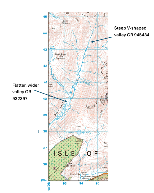
Worked Example
Study Ordnance Survey map extract (Item A) (opens in a new tab) of the Arran area.
Using map evidence, describe the physical features of the Iorsa Water and its valley between 950450 to 920383.
You may use grid references in your answer.
Examiner Tips and Tricks
The example shows how you can use contour lines to identify physical features of an area. Look at how close the contour lines are together and the shape of the lines.

Unlock more, it's free!
Join the 100,000+ Students that ❤️ Save My Exams
the (exam) results speak for themselves:

Was this revision note helpful?