Impact of Earthquakes & Volcanoes (SQA National 5 Geography): Revision Note
Exam code: X833 75

Impacts of Earthquakes and Volcanoes
Earthquakes and volcanoes cause both primary and secondary hazards
Primary hazards are a direct result of the earthquake or eruption
Secondary hazards are triggered by the primary hazards
Primary and secondary hazards caused by earthquakes and volcanoes
| Primary hazards | Secondary hazards |
Earthquake | Ground shaking Surface rupture
| Liquefaction Landslides Tsunami Fires |
Volcanic eruption | Pyroclastic flows Lava flows Volcanic bombs Lahars (mudflow) Earthquakes Direct ashfall Toxic gases | Landslides Tsunami Acid rain Ash fallout from the atmosphere
|
Although the characteristics of earthquakes and volcanic eruptions are very different, many of the impacts are similar
Impacts include:
Loss of life and injury
This may be immediate, through falling buildings or pyroclastic flows
Alternatively, it may be in the days and weeks after the event due to unclean water or disease
Collapse or destruction of buildings
This leads to people being homeless for months or even years after the event
Damage to the transport network
Roads, bridges and railways may be damaged or destroyed
This can impact the speed at which aid can get to affected areas
Loss of jobs and businesses
This impacts the economy when factories and offices are damaged or destroyed
Loss of crops
This leads to food shortages and affects farmers’ incomes
Power and water supply are damaged
This affects the supply of clean water and electricity
Damage to the environment
This includes loss of vegetation and habitat
The ash and gas released during an eruption can impact the climate
Closure of airports
It is dangerous for jet planes to fly through ash clouds due to possible engine failure, so flights are cancelled
Impacts of Earthquake
Case Study
Case Study: Nepal
Located between India and China, Nepal is a landlocked country
In 2015, Nepal was a low-income country, with a GDP per capita of less than $1000
80% of the population lived in rural, often remote, communities
Earthquake, April 2015
In April 2015, at 11.26am, Nepal was struck by an earthquake, magnitude 7.8
The epicentre was 80km northwest of the capital city, Kathmandu, in the Gorka district
The focus was shallow, just 15km below the surface
Over 300 aftershocks followed the main earthquake
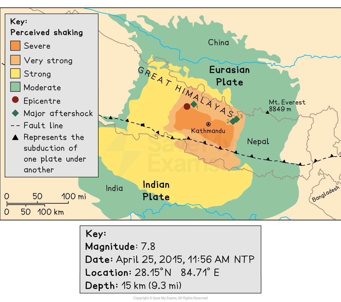
Cause
Nepal is located on a collision boundary between the Indian and Eurasian plates
Impacts on people
Approximately 8600 deaths
Over 20,000 people were injured
Many survivors suffered stress, anxiety and trauma
Electricity and water supplies were cut, reducing the standard of living
Approximately 8300 schools were damaged or destroyed, reducing access to education
Over 1000 health facilities were destroyed, reducing access to healthcare
Almost 3.5 million people were made homeless
Job losses and reduced tourist income meant that people were unable to make a living
Damages estimated between $7 and $10 billion (about 35% of total GDP)
Impacts on the landscape
More than 20,000 landslides blocked roads and rivers
Rivers were blocked by landslide dams, creating large temporary lakes, which increased the risk of sudden and catastrophic flooding
Avalanches on Mount Everest and in the Langtang Valley
Sediment from landslides choked rivers, contaminating water sources and threatening aquatic life
Large areas of forest were damaged and destroyed, causing loss of biodiversity and wildlife habitats
Thousands of homes, offices, shops and factories were destroyed
Many historic temples and UNESCO World Heritage sites were destroyed, e.g. Dharahara Tower
Impacts of Volcanoes
Case Study
Case study: Mount Merapi, Indonesia
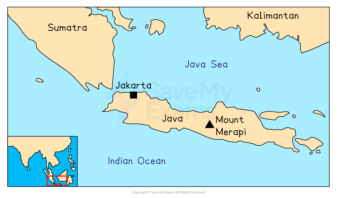
Indonesia forms part of the Pacific ‘Ring of Fire’
There are around 130 active volcanoes in Indonesia
Mount Merapi, located on the island of Java, is the most active volcano in Indonesia
Its name means ‘Mountain of Fire’
The area is very densely populated, with hundreds of thousands of people living within a few kilometres of the volcano
Eruption, October 2010
Mount Merapi began to erupt on October 25, 2010
The eruption lasted for around a month
The magnitude was VEI 4
It was the most significant eruption since 1872
Cause
A destructive plate boundary where the Indo-Australian plate is subducting below the Eurasian plate
Impacts on people
Over 350 people died
Injuries and illnesses e.g. sulphur dioxide gas, caused skin irritation and breathing problems
350,000 people were displaced
Many survivors suffered stress, anxiety and trauma
Services like healthcare and education were disrupted
Roads and bridges were damaged, disrupting trade and economic activity
Crops were destroyed and livestock killed, leading to rising food prices
Job losses and reduced tourist income meant that people were unable to make a living
Economic losses of £450 million
Impacts on the landscape
Thick layers of ash covered the landscape, reaching up to 480km from the volcano
Ash mixed with rainwater during the rainy season, causing lahars (volcanic mudflows)
Farmland was buried under thick layers of ash and mud
Over 200 hectares of forest were damaged, causing loss of habitats and biodiversity
Ash and acid rain contaminated rivers, damaging ecosystems and threatening aquatic life
Over 3000 homes and buildings were destroyed
Examiner Tips and Tricks
Make sure you can explain the impacts of a named earthquake and a named volcanic eruption on both people and the landscape. Make revision cards to test yourself on details such as magnitude, location and death toll.

Unlock more, it's free!
Join the 100,000+ Students that ❤️ Save My Exams
the (exam) results speak for themselves:

Was this revision note helpful?
