Equatorial Tropical Forest (SQA National 5 Geography): Revision Note
Exam code: X833 75

Equatorial climate
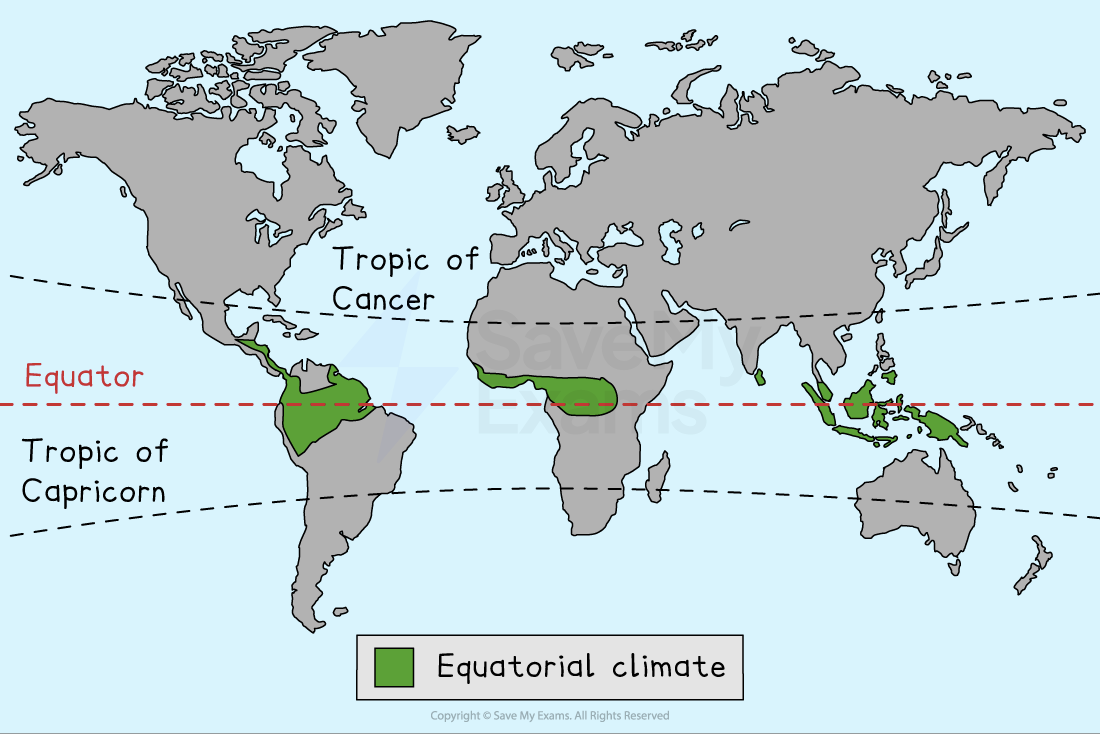
Equatorial tropical forest distribution
Tropical rainforests are located in a band between 15° north and 15° south of the equator within the equatorial climate zone
They cover 6% of the Earth’s surface and are found mostly in the following regions
South America
The Amazon is the largest remaining rainforest on Earth
It is usually associated with Brazil, but covers parts of several neighbouring countries
Central America
Including parts of Belize, Costa Rica, El Salvador, Guatemala, Honduras, Nicaragua and Panama
Central Africa
Including Cameroon, the Central African Republic, the Republic of Congo, the Democratic Republic of Congo (DRC), Equatorial Guinea and Gabon
South East Asia
Including Malaysia, Indonesia, Thailand, the Philippines and Papua New Guinea
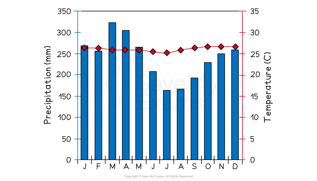
Equatorial Climate
Temperatures are high all year round
Between 26–28°C
Precipitation is high all year round
Over 2000 mm per year
Humidity is high
Usually over 75–80%
There are no seasons
It is hot and wet all year round
Tropical rainforest ecosystem
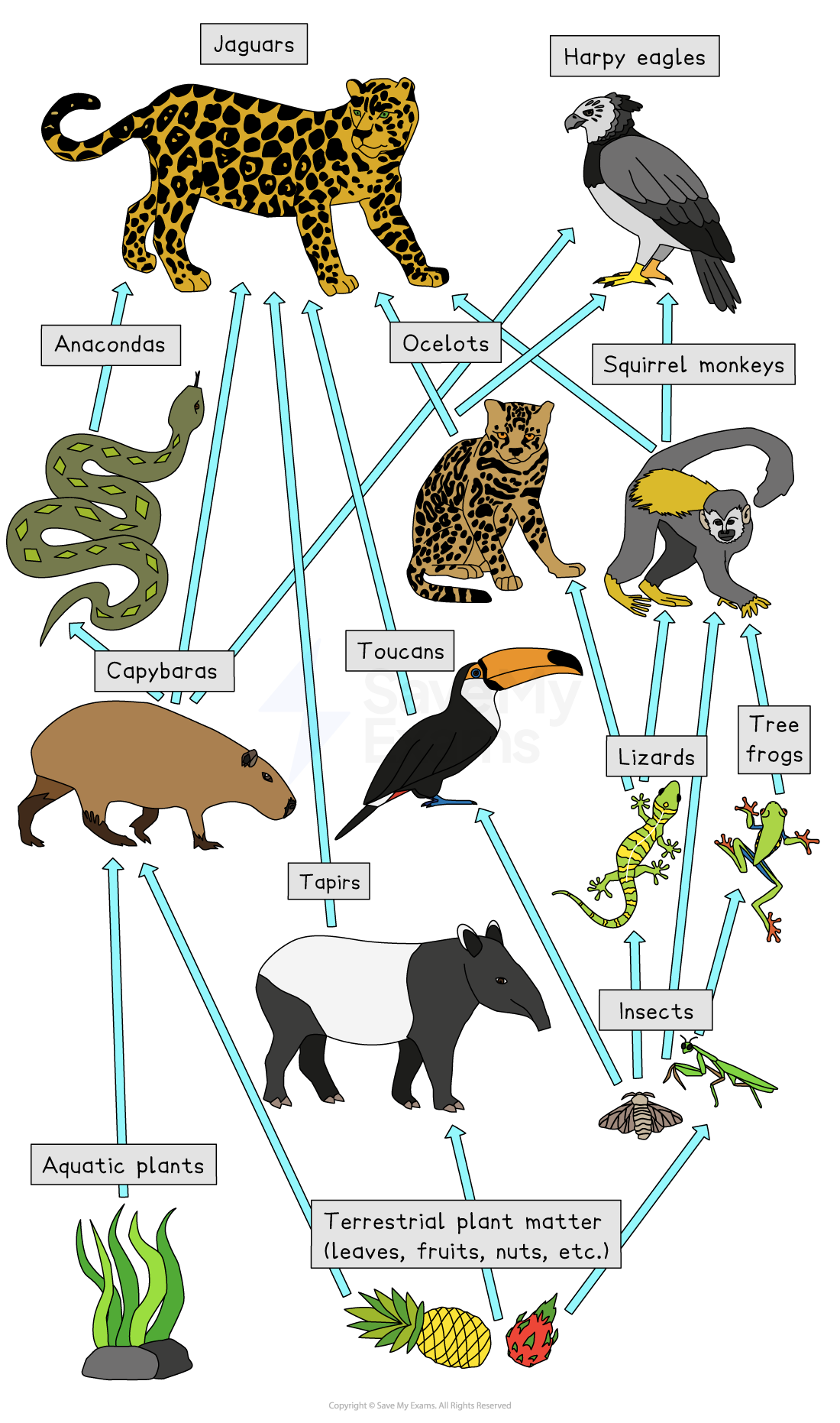
Tropical Rainforests contain the highest biodiversity of plants and animals on Earth
The wet and warm climate means there is a continual growing season
Rapid nutrient cycling increases plant growth
The structure of the tropical rainforest, with multiple layers, increases biodiversity
Each layer has a different level of light, temperature and humidity, with different food sources
This creates lots of distinct habitats which support a wide variety of plant and animal species
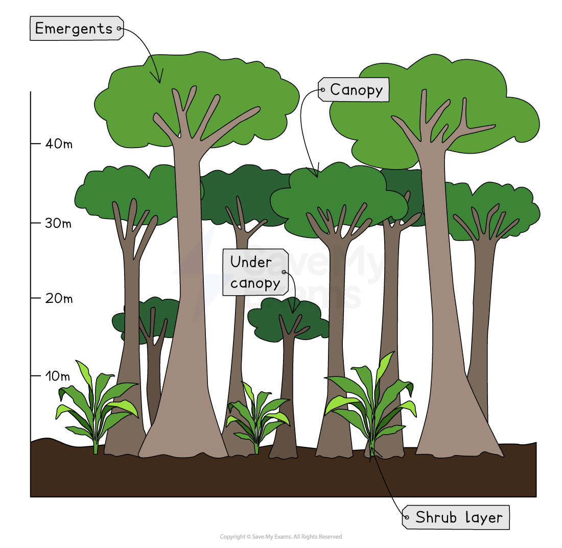
Structure of the tropical rainforest
The tropical rainforest has five distinct layers
Ground layer (0m)
Darkest layer with very little sunlight
Humid and damp
Covered with a thick layer of leaf litter, which decays rapidly
Insects and animals such as tapirs and jaguars are found here
Shrub layer (3–4m)
Quite dark with little sunlight
Low-growing plants and shrubs
Insects and small animals like snakes and mice are found here
Under canopy (15m)
Most light is blocked by the canopy layer
Due to a lack of light, trees tend to be relatively small and young
Vines grow around trees to try to reach more light
Animals like frogs and monkeys are found here
Canopy (30m)
Lots of sunlight
Thick layer of mature trees
Many animals, such as toucans, sloths and orangutans, live here
Emergents (45–55m)
Full sunlight and strong winds
Tallest trees rise above the canopy layer
Animals like eagles, bats and butterflies are found here
Plants and animals within the tropical rainforest are very well adapted to the climate conditions and the light available
Plant adaptations
Waxy leaves with drip tips
Ensure that rainwater runs off the leaf and does not remain, which would encourage mould growth or break the leaf
Buttress roots
Large roots above the ground help to support very tall trees because the roots below the surface are shallow
Lianas
Vines which climb up tall trees to reach sunlight
Epiphytes
Plants that grow on trunks and branches of trees and get nutrients from air, rain or debris accumulating around the plant
Straight, smooth trunks
To reduce the number of epiphytes on the tree
Animal adaptations
Sloth
Algae grow in the fur of the sloth, helping to camouflage it
Toucan
Has a large bill to reach and cut fruit from the branches of trees
Primates
Have prehensile tails to help them climb trees
Gecko
Have large, flattened toe pads with sticky scales, which allow them to grip the smooth tree trunks
Stick insects
Their stick and leaf shapes help them to be camouflaged
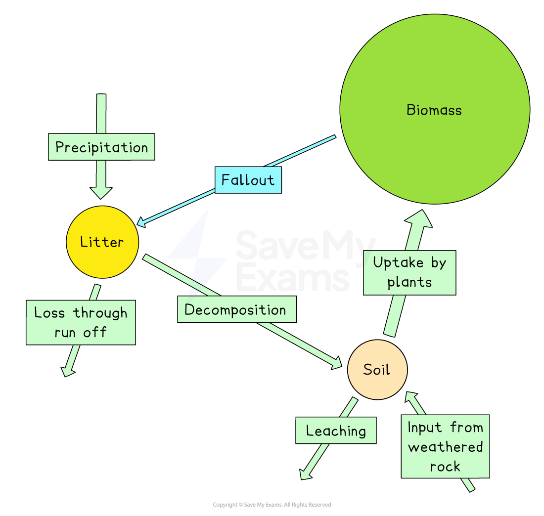
The nutrient cycle
The nutrient cycle in the tropical rainforest is rapid
Trees and plants lose their leaves all year round
This moves nutrients from the biomass store to the litter store
The high level of moisture and high temperatures lead to rapid decomposition
This moves nutrients from the litter store to the soil store
Plants grow quickly, leading to the rapid uptake of nutrients from the soil
This moves nutrients from the soil store to the biomass store
This means that the soil in the tropical rainforest is not very fertile because nutrients in the soil are used by plants to grow
Examiner Tips and Tricks
You can tell which store of nutrients in the tropical rainforest is the largest by comparing the size of the circles in the diagram.
The largest store of nutrients is the biomass (the living plants and animals), whereas the soil is the smallest store. If vegetation is removed, the biomass store will shrink. This will lead to the litter and soil stores becoming even smaller, and eventually, the soil will become infertile.
Worked Example
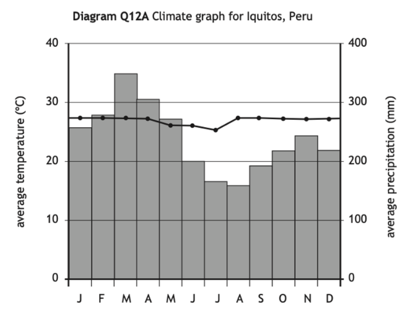
Study Diagram Q12A
Describe in detail the climate graph for Iquitos in Peru.
[4 marks]
Example answer
Iquitos has consistently high temperatures all year round [1] with a small temperature range of 2°C [1]
The highest rainfall is in March at approximately 350 mm [1] but there is over 100 mm of rainfall every month [1]
Examiner Tips and Tricks
When you answer a climate graph question, remember TEA
T – Trend
Describe the overall pattern, e.g. highest and lowest temperature, highest and lowest precipitation, whether rainfall is seasonal or evenly spread throughout the year
E – Evidence
Use data to support your point by quoting the temperature in °C and rainfall in mm and referring to relevant months. Calculate the temperature range or the total rainfall.
A – Anomaly
Point out anything that doesn’t fit the pattern, e.g. a sudden drop or spike in temperature or rainfall

Unlock more, it's free!
Join the 100,000+ Students that ❤️ Save My Exams
the (exam) results speak for themselves:

Was this revision note helpful?
