Coastal Landscapes: Processes (SQA National 5 Geography): Revision Note
Exam code: X833 75

Specification checklist
This page covers what you need to know from the SQA National 5 geography specification to answer questions on:
The identification and formation of the following landscape features:
Cliffs, caves and arches, stacks, headlands and bays, spits and sand bars
The processes of coastal erosion
Destructive waves are responsible for the majority of erosion that happens along a coast
There are four types of erosion:
Hydraulic action
Abrasion
Attrition
Solution
Hydraulic Action
This is the sheer force of waves crashing against the shore and cliffs.
The power of the waves forces air into cracks, compresses it and breaks the rock apart as the pressure is released
Abrasion/Corrasion
Rocks and pebbles carried in the waves wear away the coastline as they are thrown against it (the sandpaper effect)
Corrosion/Solution
When chemicals in the seawater dissolve minerals in the rocks, causing them to break up.
Attrition
When rocks and pebbles carried by the waves smash into each other
Examiner Tips and Tricks
Take time to learn these terms and definitions. When explaining coastal landform formation, it is important to use these terms as part of the explanation.
Formation of coastal erosion features
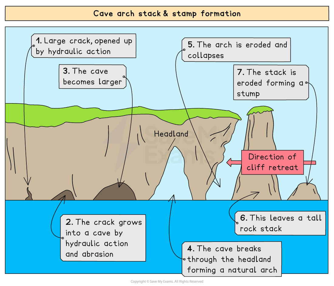
Cave and arch formation
The waves attack a line of weakness, such as a fault line, in the headland
Erosion, such as hydraulic action, widens the gaps/cracks
Over time, hydraulic action enlarges the crack and it develops into a sea cave (e.g. Tilly Whim caves)
As the cave becomes larger, abrasion wears away the back and sides of the cave (the sandpaper effect)
Further erosion of the cave, from opposite sides of the headland, cuts through the rock to form an arch (e.g. Durdle Door)
Stack formation
The base of the arch is attacked by the waves and gets wider, so the top of the arch collapses
This leaves behind a freestanding piece of rock called a stack, which is separate from the headland (e.g. Old Harry)
Cliff formation
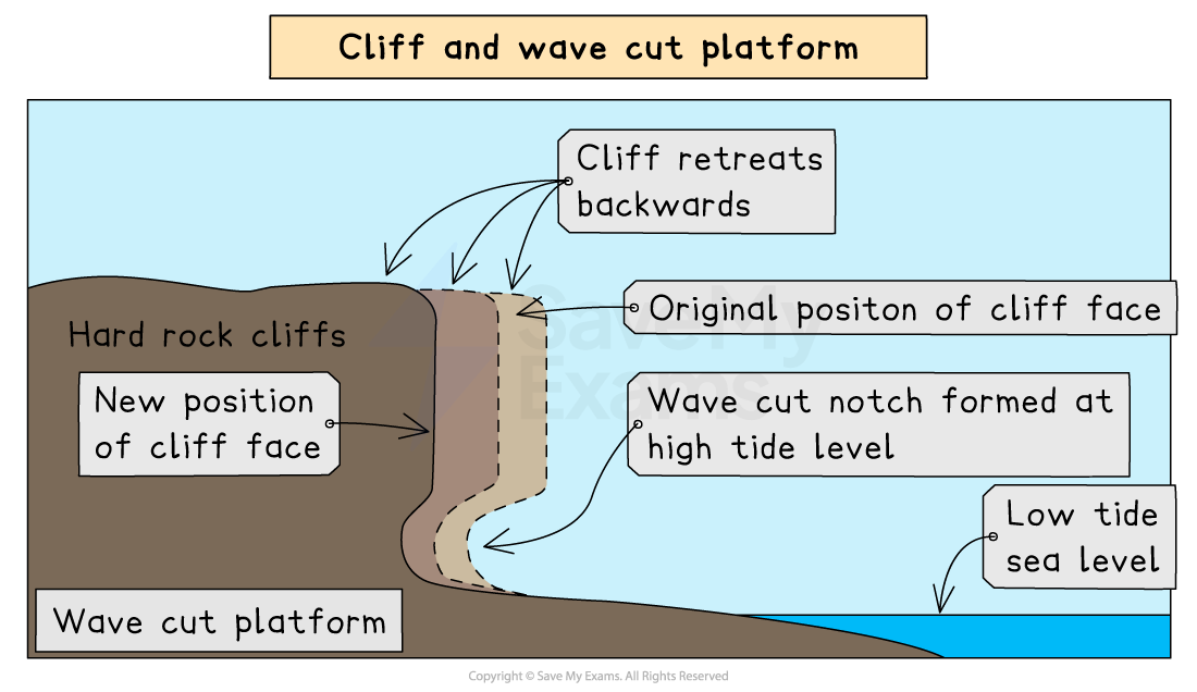
Cliffs usually form where there is harder, more resistant rock, such as limestone and chalk
Wave erosion is strongest where large waves break against the base of the cliff
A wave-cut notch will be formed as the cliff is undercut by the erosive power of the waves, through the processes of hydraulic action, solution (corrosion) and abrasion (corrasion)
Eventually, the cliff above the notch becomes unsupported and collapses into the sea
The cliff retreats and leaves behind a gentle sloping shelf of rock, a wave-cut platform, which is visible at low tide
Formation of headlands and bays
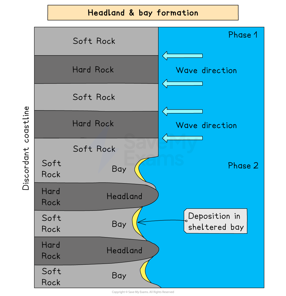
Headlands and bays are found in areas where there are bands of alternating hard and soft rock, which meet the coast at right angles (for example, sandstone, a hard rock, and clay, a soft rock)
Headlands and bays are formed by differential erosion
The softer, less resistant rock erodes backwards more quickly, forming bays
When formed, the bays then become sheltered by the headlands, and erosion slows down.
The harder rock erodes more slowly, forming headlands which are left sticking out as rocky outcrops.
The headlands are then vulnerable to erosion as the wave's energy is concentrated here
Process of coastal transportation
There are three parts of coastal transportation, which result in the formation of many coastal landforms:
1. Swash and backwash – movement up and down a beach
2. Longshore Drift – movement along a coastline
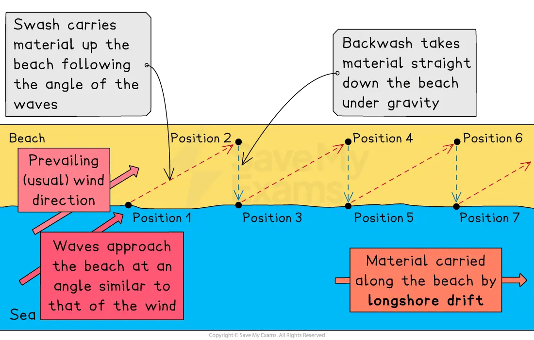
Longshore Drift
Every time a wave breaks, the swash washes sand up the beach at an angle, in the direction of the prevailing wind
The water then washes straight back down the slope of the beach, perpendicular to the coastline, taking sand with it
Over time, sand is moved along the beach
This process is called longshore drift.
On many coasts, longshore drift is in one direction, e.g. on the south coast of England, where the prevailing wind and the maximum fetch are both from the south – west, there is a dominant movement of beach materials eastwards
Coastal deposition features
Formation of spits
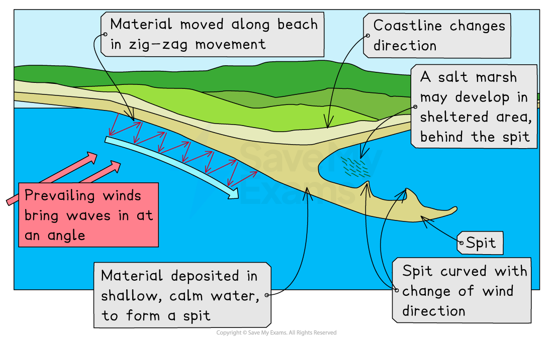
Sand spits are long, narrow ridges of sand or shingle which form where the coastline changes direction
Longshore drift transports sand along the coastline and deposits it in a shallow or sheltered area
The deposited sand builds up over time until it is above sea level
This deposition continues until the beach extends into the sea to form a spit
Sand spits can also develop a hooked or curved end due to a change in prevailing wind/wave direction
Formation of sand bars
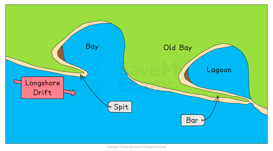
Sand bars are long, narrow ridges of sand or shingle which join one headland to another
When the spit forms across a bay, it reaches another headland forming the bar
Worked Example
Look at Diagram Q1.
Explain the formation of a sand bar.
You may use a diagram(s) in your answer.
[4 marks]
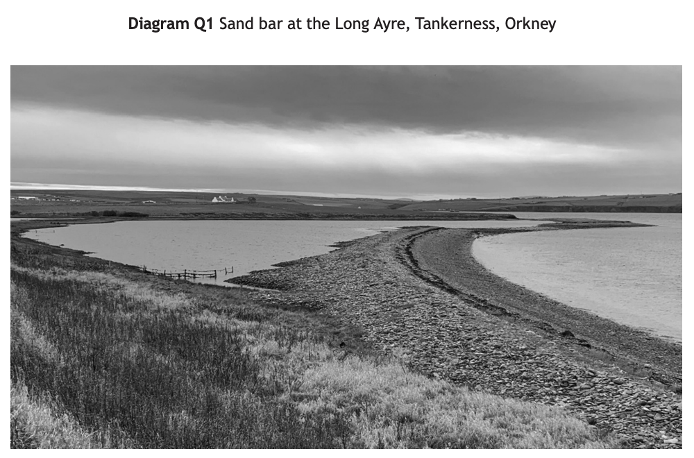
Example answer
Longshore drift [1] transports and deposits sand, which builds up over time until it is above sea level, [1] as the deposits grow into the sea, a sand spit is formed [1] if the spit continues to grow until it joins up with the opposite side of a bay, a sand bar is formed. [1]
Examiner Tips and Tricks
You can gain full marks using well-annotated diagrams to support your answer. Just as you like having a visual prompt, it helps the examiner to see that you do know the answer. Occasionally, a diagram is easier than actually writing it all out.

Unlock more, it's free!
Join the 100,000+ Students that ❤️ Save My Exams
the (exam) results speak for themselves:

Was this revision note helpful?
