Case Study: Limestone Landscapes (SQA National 5 Geography): Revision Note
Exam code: X833 75

Specification checklist
This page covers what you need to know from the SQA National 5 geography specification to answer questions on:
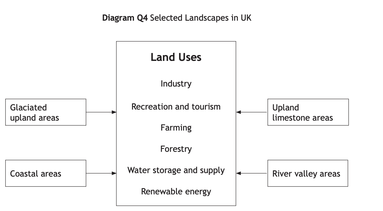
Land uses appropriate to the two landscape types studied should be chosen from:
Farming
Forestry
Industry
Recreation and tourism
Water storage and supply
Renewable energy
In the context of one landscape type studied:
The conflicts which can arise between land uses within this landscape
The solutions adopted to deal with the identified land use conflicts
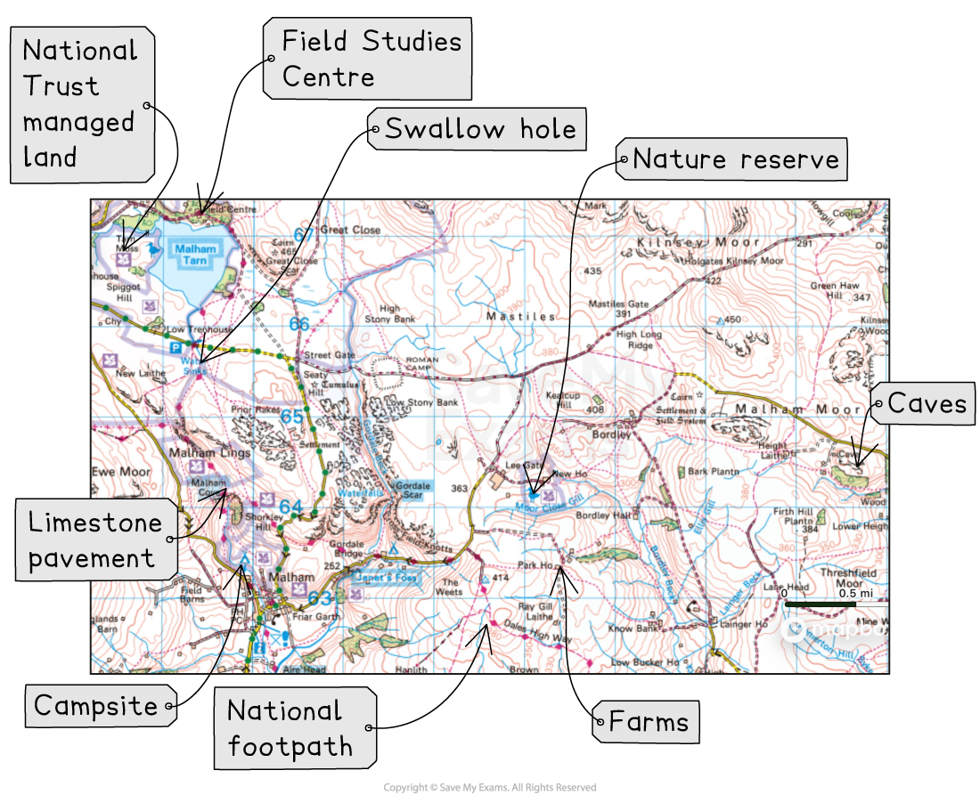
Landuse in a limestone landscape
There are many different land uses in limestone landscapes, including:
Recreation and Tourism
Residential
Industry - Quarrying
Forestry
Renewable Energy
Farming (dairy)
There are many conflicts between the different land uses
Examiner Tips and Tricks
It is important that you are able to recognise the land uses on an OS map and can refer to evidence from an OS map if required by the question. Map evidence includes:
Place specific names
Road numbers
Grid references
Yorkshire Dales National Park
Located in North Yorkshire, England
The Yorkshire Dales National Park covers 2,178km2
Established in 1954
It contains extensive areas of limestone landscapes
Several organisations manage the limestone areas:
The National Park Authority
The Yorkshire Wildlife Trust
Natural England
Plantlife International
The National Trust
Land use in the limestone landscape
Tourists
The Yorkshire Dales National Park attracts over four million visitors per year
The area is popular for:
Walking
Hiking
Sightseeing
Climbing
Caving/potholing
Camping
Conservation
As with all National Parks, the land is protected by law
Many conservation groups are involved in preserving the natural landscape, including:
The Yorkshire Wildlife Trust
Natural England
Plantlife International
The National Trust
The limestone pavements are protected by:
Limestone Pavement Orders (LPOs)
Sites of Special Scientific Interest (SSSIs)
Farming
The hills in the Yorkshire Dales are used for sheep farming
The lower land is used to grow some crops, and for beef and dairy
Many farmers diversify by having holiday cottages, glamping pods, farm shops and other activities, for example:
West Close Farmhouse Cottages
Town End Farm shop
Quarrying
Limestone and gritstone are quarried in the Yorkshire Dales
Examples include:
Swinden quarry and Horton quarry
Renewable energy
Large-scale renewable energy projects are restricted because the area is covered by the National Park
Hope Moor Wind Farm is proposed for the edge of the National Park
There are also proposed small-scale hydropower schemes, such as at Winterburn Reservoir, Malhamdale
Worked Example
Explain different ways in which people use limestone landscapes.
[4 marks]
Tourists visit to see the attractive landscape [1]
Climbing and abseiling on the steep limestone [1]
Hill sheep farming is the main agriculture due to the steep slopes and poor grazing land [1]
Limestone and gritstone are quarried [1]
Conflict between land users in limestone uplands
Farming v tourism
Farming activities often conflict with walkers’ rights of access
Farmers may not want tourists walking over their land
Walkers may leave gates open, allowing livestock to escape
Farmers may lose profits
Farmers have to spend time and effort finding the animals
Tourists' dogs off the lead
The dogs may chase sheep and injure or kill them
This is stressful and traumatic for the farmer
May lead to lost profits
Stone walls may be damaged if tourists try to climb over them
These cost money to repair
Careless tourists might drop litter, which animals might choke on and die
Litter makes the farmland look visually unappealing
Quarrying v tourism
Quarrying is often in conflict with tourism because it spoils the appearance of the countryside
Swinden Quarry in the Yorkshire Dales
Quarrying also leads to heavy traffic on narrow roads, causing congestion
The traffic also creates noise and air pollution, all of which might put tourists off visiting the area
Conservation v tourism
Footpath erosion
Walkers may walk around muddy sections of path, widening it over time
Erosion of land destroys habitats and impacts wildlife
Tourists may drop litter
Litter can be a choking hazard for livestock and wildlife
The litter may contaminate the soil when it breaks down
Tourists v locals
Second homes are popular in areas such as Hawes and Malham
Approximately 20% of housing is a second home or holiday let in the National Park
This increases house prices
Local people cannot afford the prices
They have to live elsewhere
Worked Example
Look at Diagram Q4.
Choose one landscape from Diagram Q4.
For a named area you have studied, explain ways in which different land uses may be in conflict with each other.
[6 marks]
Example answer
In the Yorkshire Dales, walkers may leave gates open, allowing animals to escape [1]. This may cost farmers money if they lose the livestock. [1]
Stone walls may get damaged by people climbing over them. [1]
Quarrying in places like Swinden Quarry may lead to noise which disturbs tourists [1]
Tourists parking on the narrow roads in the Yorkshire Dales may stop farmers from being able to move large farm vehicles [1]
Farmers may restrict where tourists can walk to stop them from disturbing livestock [1]
One mark is awarded for each valid point
Two marks may be awarded if a point is developed
The answer must refer to a specific place, such as the Yorkshire Dales. Answers that do not include this will be awarded a maximum of five marks.
Solutions to conflicts
Farmers install swing-hinge or self-closing gates so they close automatically, ensuring animals do not escape
Train lines, buses and cycle routes offer alternative forms of transport
This reduces traffic congestion on narrow roads
The National Park Authority helps manage land, for example:
Repairing footpaths
Issuing parking fines to those parked illegally
Local authorities fine people for dropping litter
Areas of severe footpath erosion are cordoned off to allow the ground to repair itself
Quarries are screened with fast-growing trees to reduce the visual impact
When stone is being blasted, hose pipes spray water to reduce dust pollution
The Yorkshire Dales National Park Authority has approved measures to prevent new housing from being used as a second home or holiday let

Unlock more, it's free!
Join the 100,000+ Students that ❤️ Save My Exams
the (exam) results speak for themselves:

Was this revision note helpful?
