Case Study: River Landscapes (SQA National 5 Geography): Revision Note
Exam code: X833 75

Specification checklist
This page covers what you need to know from the SQA National 5 geography specification to answer questions on:
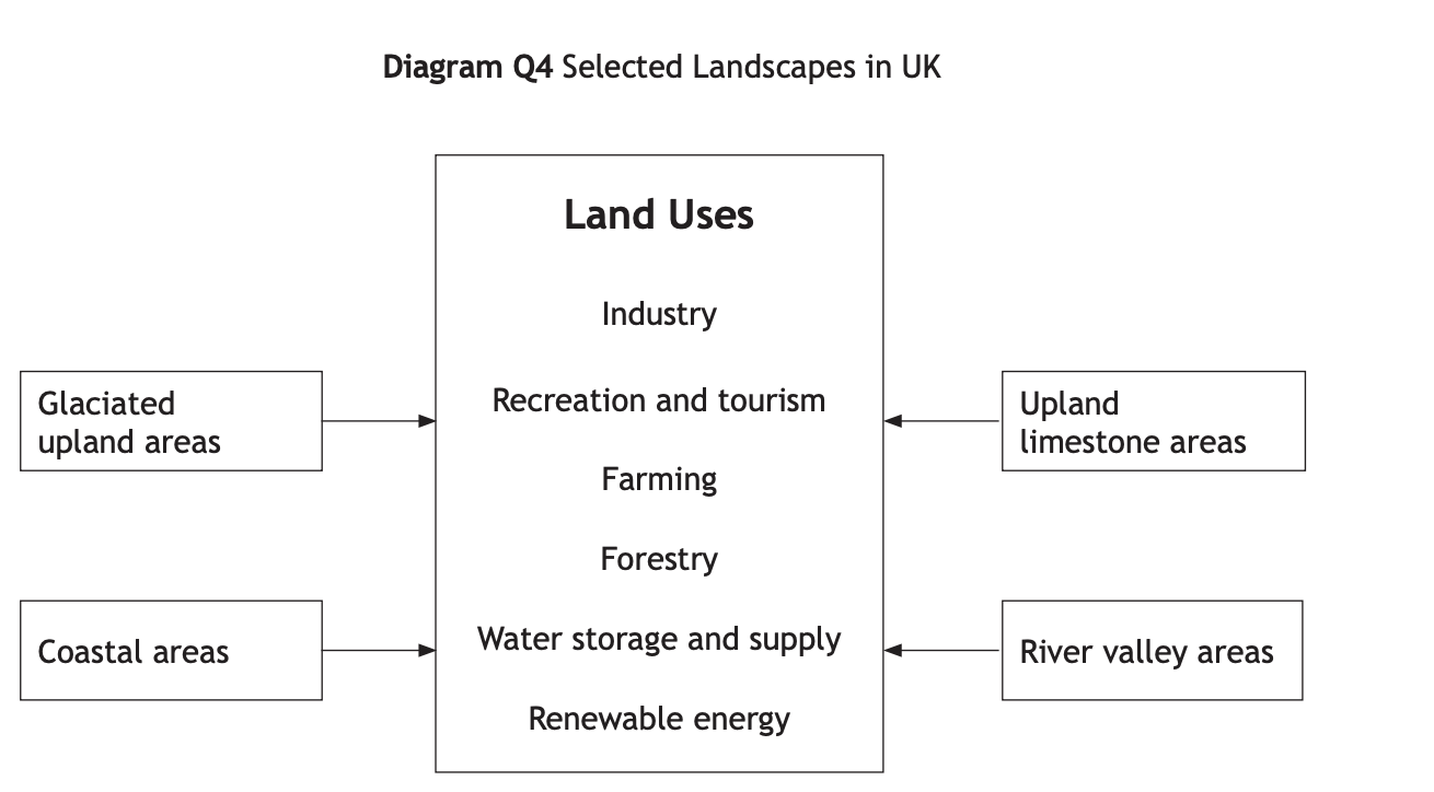
Land uses appropriate to the two landscape types studied should be chosen from:
Farming
Forestry
Industry
Recreation and tourism
Water storage and supply
Renewable energy
In the context of one landscape type studied:
The conflicts which can arise between land uses within this landscape
The solutions adopted to deal with the identified land use conflicts
Landuse in a river landscape
There are many different land uses in coastal landscapes, including:
Recreation and Tourism
Residential
Industry - Quarrying
Forestry
Renewable Energy
Farming (dairy)
There are many conflicts between the different land uses
Examiner Tips and Tricks
It is important that you are able to recognise the land uses on an OS map and can refer to evidence from an OS map if required by the question. Map evidence includes:
Place specific names
Road numbers
Grid references
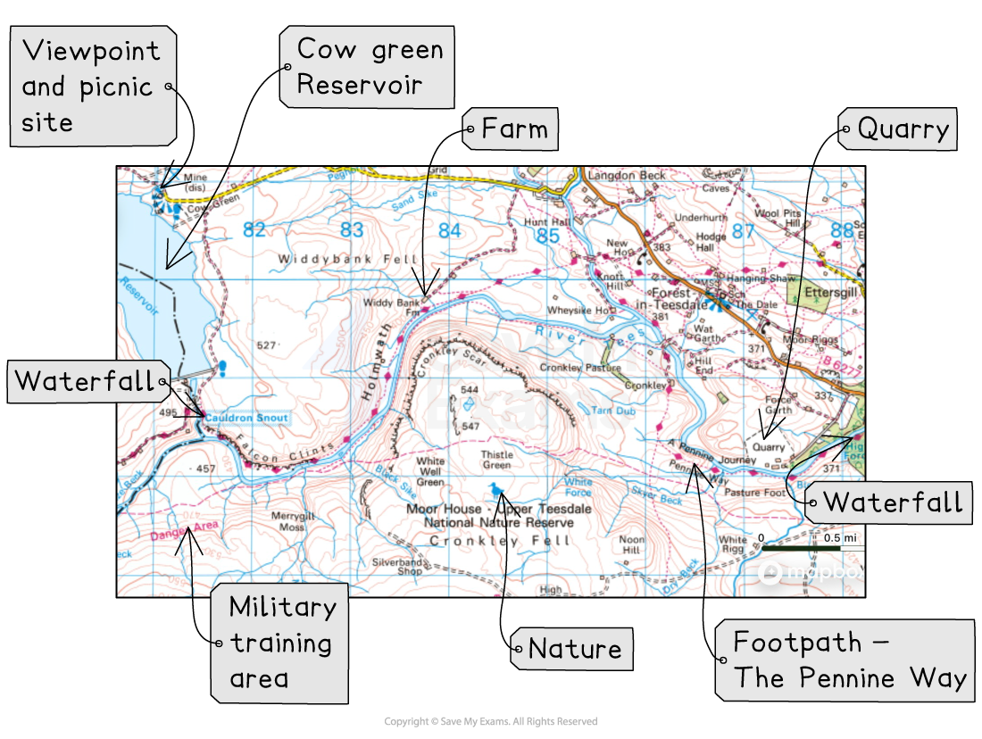
River Tees
The River Tees is located in North-East England
Its drainage basin is approximately 1830km2
The river has its source on Cross Fell, in the North Pennines, 754m above sea level
It flows 137km to the mouth at the Tees Estuary, North Sea
River features include V-shaped valleys, waterfalls, meanders, ox bow lakes and levées
The river and surrounding area are managed by several organisations, including:
Canal & River Trust
Environment Agency
Tees River Trust
Local authorities
Natural England
Landuse in the coastal landscape
Tourists
There are many visitors to landforms, such as High Force, on the river, as well as to the surrounding area
The area has lots of towns and villages, which have places to stay
People visit for the:
Walking
Mountain biking
Camping
Sightseeing
Historic buildings such as Barnard Castle
Conservation
The river passes through the North Pennines Area of Outstanding Natural Beauty (ANOB) and several Sites of Special Scientific Interest (SSSIs)
The area is also a UNESCO Global Geopark
Many conservation groups are involved in preserving the natural landscape, including:
Tees Valley Wildlife Trust
Tees River Trust
RSPB Saltholme
Tees Environmental Trust
Farming
Farming types along the River Tees include:
Sheep farming around the upper reaches of the river
Arable and cattle farming in the lower reaches of the river
Renewable energy
There are several wind farms in the River Tees area, including:
Wetherfell Wind Farm
Glass Moor Wind Farm
Many solar farms are also planned for the region, including:
Byers Gill Solar Farm
Quarrying
Historical there were lots of quarries in the area
Currently, there is small-scale quarrying of whinstone
Water storage and supply
Reservoirs along the River Tees have been built to store water to supply homes and industries in the lower course
Cow Green is the largest reservoir at two miles long
Conflicts in the river landscape
Tourists v Farmers
There are many ways in which tourist activities conflict with farmers, these include:
Runoff from farm fertilisers can poison fish and pollute water
This impacts tourists using the river for recreational fishing, so they choose to go elsewhere
Tourists' dogs off the lead
The dogs may chase sheep and injure or kill them
This is stressful and traumatic for the farmer
May lead to lost profits
Walkers may leave gates open
This allows livestock (sheep/cattle) to escape from fields
This is time-consuming for the farmer
It may be costly if livestock become trapped/injured (vet bills)
Footpath erosion
Walkers may walk around muddy sections of the path, widening it over time
Erosion of grazing land means farmers have to reseed the grass
Tourists usually travel by car
Parking of vehicles may block access to farmers' fields or driveways
This can cause frustration and reduce productivity
Traffic congestion may increase local residents' journey times, especially around 'honeypot' areas, e.g. High Force, Barnard Castle
Farm vehicles may slow tourist traffic
Tourists v military
Many tourists visit the North Pennines to enjoy peace and quiet in nature
Gunfire from a military shooting range disrupts the peace and quiet
Military training restricts access to certain areas, e.g. near Warcop Fell
Tourists v water supply
Fuel, litter, sunscreen and human waste can contaminate the water when they are being used for watersports
This means additional water treatment is needed
Tourists v renewable energy
Wind turbines are at least 30m high
Some people may find this visually unappealing
Accommodation close to the turbines may be impacted by noise pollution
Tourists v conservation
Footpath erosion
This impacts habitats and wildlife
Tourists may drop litter
This may be visually unappealing to other visitors
Litter can be a choking hazard for livestock and wildlife
The litter may contaminate the soil when it breaks down
Worked Example
Look at Diagram Q4.
Choose one landscape from Diagram Q4.
For a named area you have studied, explain ways in which different land uses may be in conflict with each other.
[6 marks]
Example answer
In the middle section of the River Tees, walkers may leave gates open, allowing animals to escape [1]. This may cost farmers money if they lose the livestock. [1]
Military training may lead to noise disturbing tourists or restricting where they go [1]
Tourists may drop litter, which can be harmful to wildlife [1]
Traffic congestion in 'honeypot' areas like High Force may increase local journey times [1]
Tourist accommodation near wind farms may be affected by the noise [1]
One mark is awarded for each valid point
Two marks may be awarded if a point is developed
The answer must make reference to a specific place, such as High Force or the River Tees. Answers that do not include this will be awarded a maximum of five marks.
Solutions to the conflicts
Farmers install swing-hinge or self-closing gates so they close automatically, ensuring animals do not escape
Local authorities fine people for dropping litter
Areas of severe footpath erosion are cordoned off to allow the ground to repair itself
Organisations such as the Tees Valley Wildlife Trust educate people about the wildlife and habitats in the area
Signposts to ask people to keep their dogs on leads

Unlock more, it's free!
Join the 100,000+ Students that ❤️ Save My Exams
the (exam) results speak for themselves:

Was this revision note helpful?
