River Landscapes: Processes (SQA National 5 Geography): Revision Note
Exam code: X833 75

Specification checklist
This page covers what you need to know from the SQA National 5 geography specification to answer questions on:
The identification and formation of the following landscape features:
v-shaped valleys, waterfalls, meander, ox bow lake, levee
River weathering, erosion and transportation processes
Weathering and mass movement
There are three types of weathering
These happen in-situ
Weathered material is then moved by mass movement into the river channel
Physical
Rock is broken down into smaller pieces
This occurs due to changes in temperature, such as freeze-thaw and exfoliation

Chemical
Rocks disintegrate and dissolve in slightly acidic rainwater
Biological weathering
Rocks are broken apart by the roots of plants
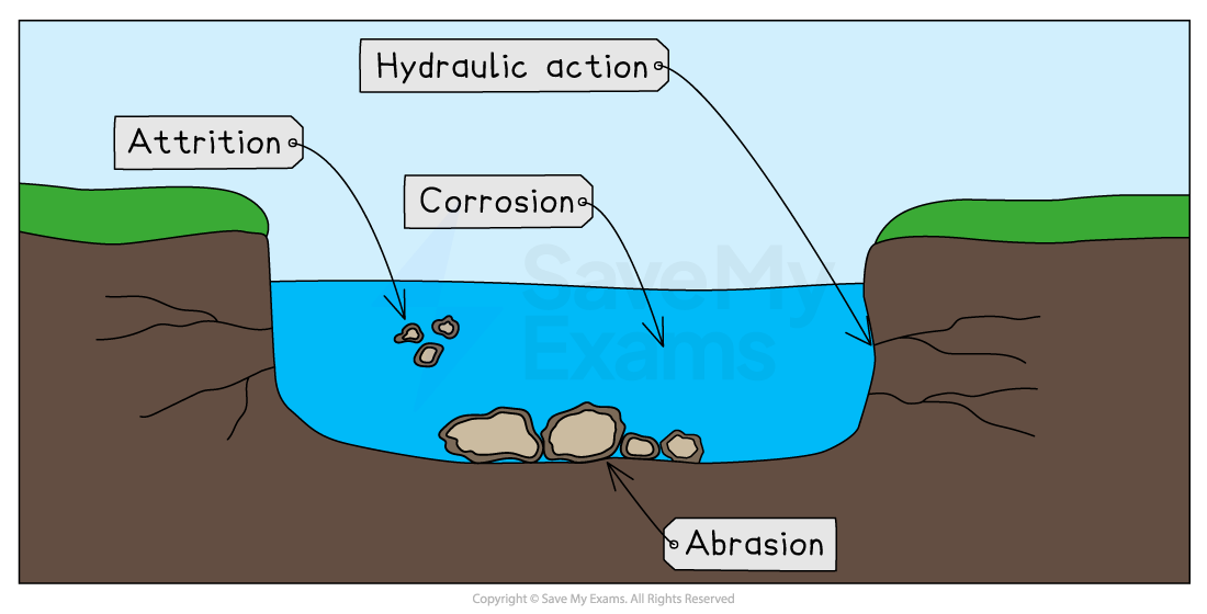
Erosion is the wearing away and removal of material
Four erosion processes change the shape of a river's channel:
Hydraulic action
Abrasion/corrasion
Corrosion/solution
Attrition
Hydraulic Action
Hydraulic action is the sheer force of waves crashing against the riverbed and banks
The power of the waves forces air into cracks, compresses it and this breaks the material of the banks apart
Abrasion/corrasion
Rocks and pebbles carried in the river wear away the bed/banks as they scrape against them (the sandpaper effect)
Corrosion/Solution
When chemicals in the river water dissolve minerals in the river channel, causing it to break up
Attrition
When rocks and pebbles carried by the water smash into each other, they wear away and gradually become smaller, rounder and smoother
The formation of upper course river features
V-shaped valley formation
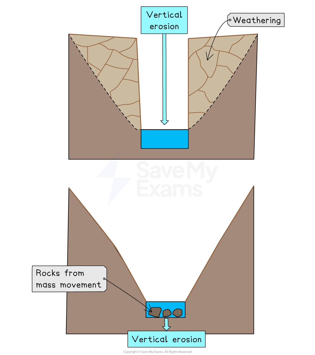
In the upper course, the river uses energy for vertical erosion, cutting down into the landscape
The river erodes a deep notch into the landscape through hydraulic action, abrasion and corrosion
As the river erodes, the sides of the valley are exposed to freeze-thaw weathering
This loosens the rocks and steepens the valley sides
Any rocks which fall into the river are used in abrasion, which leads to further vertical erosion, creating a V-shaped valley
The river transports the rocks downstream
Waterfall formation
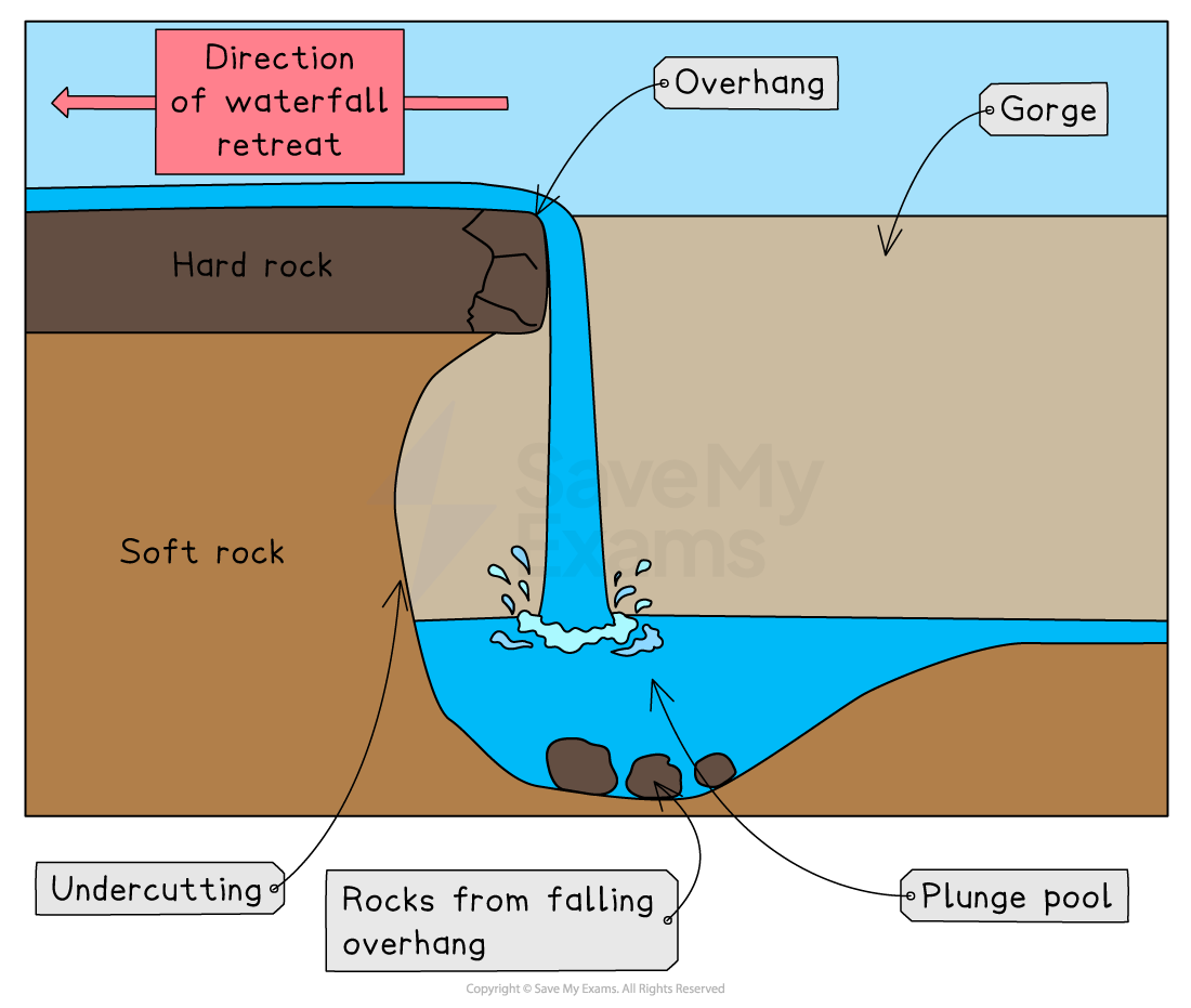
River erosion wears away the less resistant soft rock more quickly than hard rock, to form a step in the river
This is called differential erosion
The falling water erodes a deep lake called a plunge pool through hydraulic action
The swirling water causes corrosion and abrasion
This undercuts the hard rock above
There is nothing left to support the overhang of hard rock, so it collapses
The process is repeated over time
The waterfall retreats upstream,
This leaves a gorge, a deep valley with very steep sides and a narrow valley floor
The formation of middle course river features
Meander formation
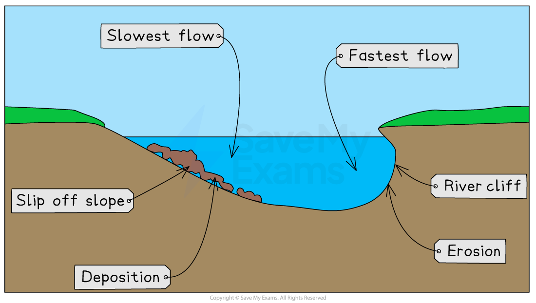
A meander is a bend in the river channel
A river has more energy for lateral (sideways) erosion in the middle and lower courses
The river contains areas of deep water and areas of shallow water, called pools and riffles
This results in areas of slower and faster water movement, meaning the current swings from side to side
In a meander, the water is pushed to the outside of the bend and greater velocity means the river has more energy to erode through abrasion
This forms a river cliff on the outside bend
The river flows more slowly on the inside bend and deposits some of its load to form a river beach/slip-off slope
Continuous erosion on the outer bank and deposition on the inner bank form a meander in the river
The formation of lower course river features
Ox bow lake formation
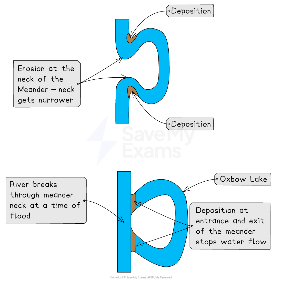
In its middle and lower courses, a river has more energy for lateral erosion
In the lower course, meanders are larger
Continual erosion on the outside of a river bend narrows the meander neck
When the river floods, it takes the shortest, most direct route
The channel cuts through the neck of the meander
Deposition occurs along the banks of the river, including the entrance and exit to the meander
Eventually, the meander is completely cut off to leave an ox bow lake
This is the old meander loop, separate from the main river channel
Formation of a levée
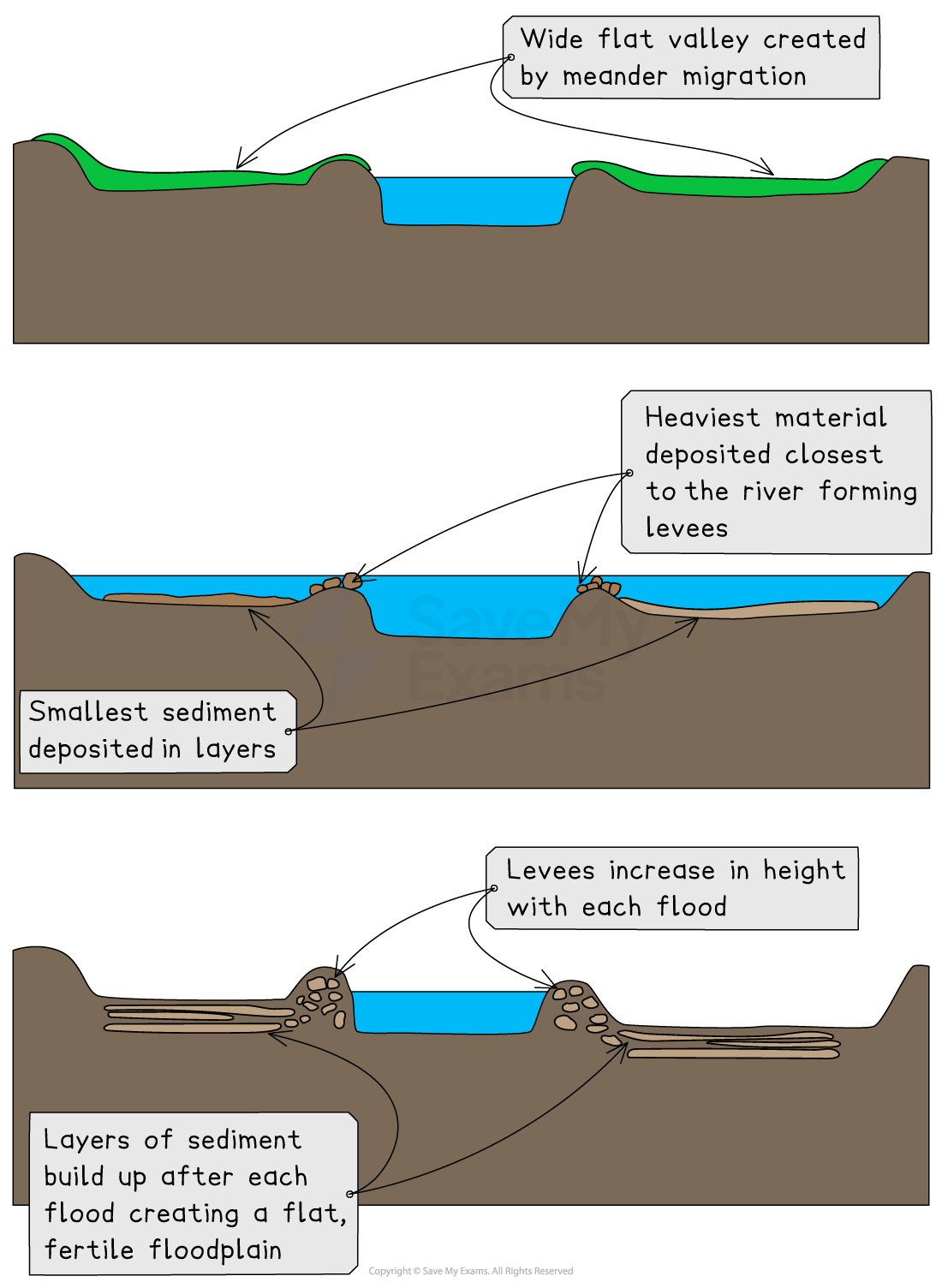
During floods, rivers overflow their banks
The water which flows onto the floodplain will initially slow down as a result of the friction between the water and the land
As the water slows, it will deposit the material it is carrying onto the floodplain
The coarsest material will be deposited first, next to the river
Over time, following multiple flood events, this builds up to form a natural embankment called a levée
Smaller sediments are carried further away from the river and deposited over the outer parts of the floodplain
Worked Example
Study the Ordnance Survey map extract (Item A) (opens in a new tab) of the Lyme Regis area.
Using grid references, describe the physical features of the River Axe and its valley between 305999 and 253900.
Your answer should include the use of grid references.
[4 marks]
The River Axe is flowing in a SW–S direction [1]
A tributary joins the river at 284973 [1]
The river meanders for example, 262948 [1]
There is an ox-bow lake at 267956 [1]

Unlock more, it's free!
Join the 100,000+ Students that ❤️ Save My Exams
the (exam) results speak for themselves:

Was this revision note helpful?
