Global atmospheric circulation (WJEC Eduqas GCSE Geography B): Revision Note
Exam code: C112

Specification links
The notes on this page cover part 2.3.2 of the WJEC Eduqas B specification
2.3.2 How does the global circulation of the atmosphere create distinctive climate zones?
An overview of the global circulation of the atmosphere to include the operation of cells in the troposphere.
An overview of the location and distribution of distinctive climate zones across the globe.
The features of the hot semi-arid climate (note the link to the study of hot semi-arid grasslands in 3.1.1) and one other climate zone.
Global circulation of the atmosphere
The atmosphere is constantly moving solar heat energy from the equator to the poles to reach a balance in temperature
Different areas of the Earth get varying amounts of energy from the sun, known as insolation
The Earth is a sphere with a permanent tilt and a slight bulge at its equator
Therefore, the equator gains solar energy, but the poles have a deficit of solar energy

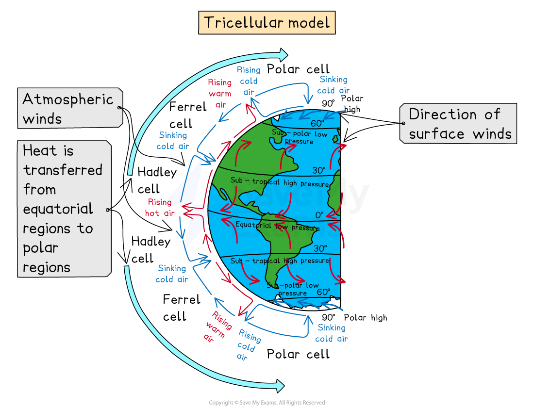
Circulation cells
In both hemispheres, heat energy transfer occurs where atmospheric circulation cells meet
Each hemisphere has three cells (the Hadley cell, Ferrel cell and Polar cell), which circulate air from the surface through the atmosphere and back to the Earth's surface
Examiner Tips and Tricks
What is weather?
Remember that weather is what you get locally on a day-to-day basis, but climate is what you expect a place to be over time (usually 30 years).
You can generally expect the UK to be wet and cold (though not always), while the Mediterranean is typically warm – this describes climate.
The Hadley cell
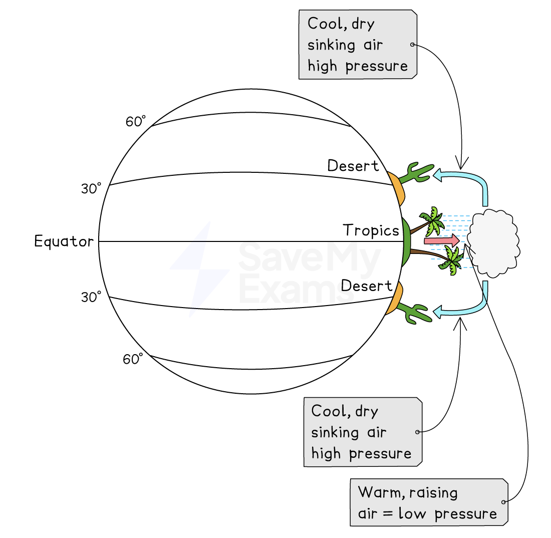
Hadley cell is the largest cell and extends from the equator to between 30° and 40° north and south
Near the equator, the trade winds meet, and the hot air rises and forms thunderstorms (tropical rainstorms)
From the top of these storms, air flows towards higher latitudes, where it becomes cooler and sinks over subtropical regions
This brings dry, cloudless air, which is warmed by the Sun as it descends – the climate is warm and dry (hot deserts are usually found here)
The Ferrel cell
The Ferrel cell is the middle cell and generally occurs from the edge of the Hadley cell to between 60° and 70° north and south of the equator
This is the most complicated cell, as it moves in the opposite direction from the Hadley and Polar cells, similar to a cog in a machine
Air in this cell joins the sinking air of the Hadley cell and travels at low heights to mid-latitudes, where it rises along the border with the cold air of the Polar cell
This occurs around the mid-latitudes and brings frequent unsettled weather (particularly for the UK)
The Polar cell
The Polar cell is the smallest and weakest of the atmospheric cells. It extends from the edge of the Ferrel cell to the poles at 90° north and south
Air in these cells is cold and sinks, creating high pressure over the highest latitudes
The cold air flows out towards the lower latitudes at the surface, where it is slightly warmed and rises to return at altitude to the poles
Atmospheric circulation affects the Earth's climate by causing some areas to experience certain types of weather more frequently than others
The UK has a lot of low-pressure weather systems that are blown in from the Atlantic Ocean on south-westerly winds, bringing wet and windy weather
Location and distribution of climate zones
Climate zones are areas with distinct climates that are distributed on Earth based on latitude and distance from oceans
Polar climates are located in the far north and south, including the Arctic and Antarctica
Characteristics: Freezing temperatures year-round, long, harsh winters, and short, cool summers, with low precipitation that falls as snow
Temperatures rarely exceed 10° C
Examples: Antarctica, Greenland, and the northernmost reaches of Canada and Russia
Temperate and continental climates are found in the mid-latitudes, between roughly 30° and 60° north and south of the equator
Characteristics: Moderate temperatures with four distinct seasons and relatively even precipitation distribution throughout the year (total annual rainfall is around 1000 mm )
Examples: Western Europe, eastern North America, and parts of Argentina and Australia
Tropical climates are around the equator
Characteristics: Hot and wet year-round, with high humidity and rainfall
Total annual rainfall between 2000 mm and 2200 mm
Temperature between 26° and 30° C daily
Examples: The Amazon rainforest in Brazil
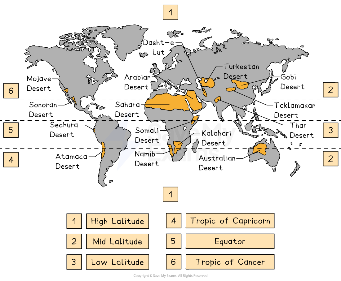
Arid (desert) climates are located along the Tropics of Cancer and Capricorn, approximately 20° to 30° north and south of the equator
Characteristics: Very low rainfall (less than 250 mm per annum) and high temperatures during the day (between 30°C and 35°C), with large temperature variations between day and night
Example: The Sahara Desert in Africa
Mediterranean climates are found in specific coastal regions between roughly 30° and 45° north and south of the equator
Characteristics: Hot, dry summers and mild, wet winters
Examples: Italy, South Africa, and southern Australia
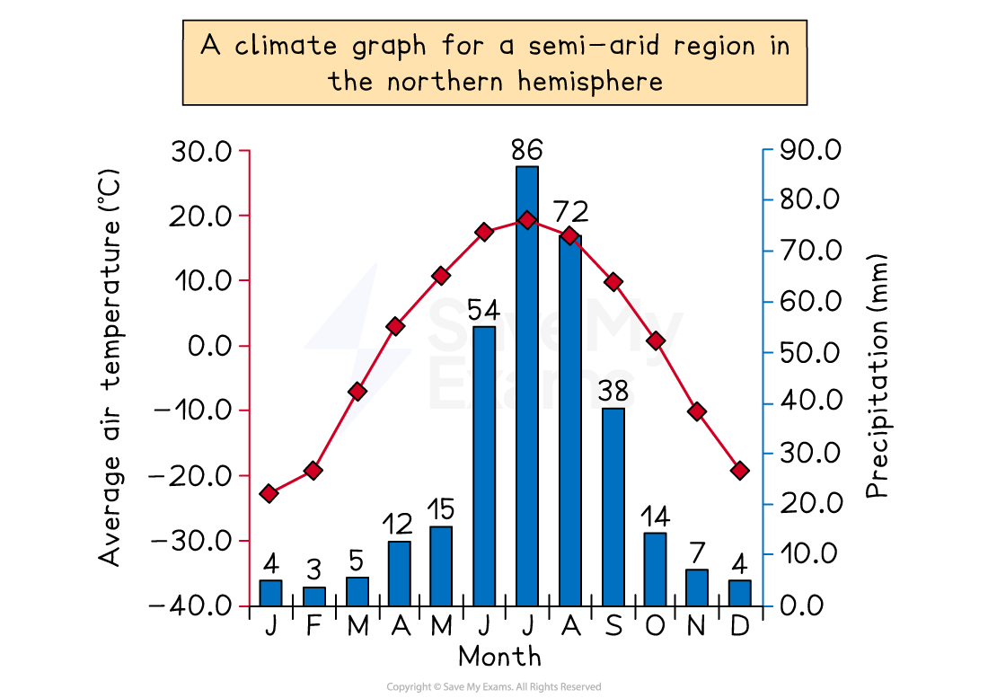
Hot semi-arid climate
Unlike hot arid deserts, hot, semi-arid climates see less than 500 mm of precipitation per year
It has low humidity and seasonal winds that can lead to dust devils
Location
Hot semi-arid climates are usually found on the edges of arid deserts, in the tropics and subtropics.
Examples include parts of Africa, Australia, and India
Climate features
Temperature: Summers are hot to extremely hot, while winters are warm to cool
There is significant diurnal temperature variation, where temperatures drop at night due to a lack of cloud cover and often exceed 40° during the daytime
Rainfall: Precipitation is under 500 mm annually and unreliable
When rain does occur, it can be so intense that it causes flash floods
Examiner Tips and Tricks
Remember that within the hemispheres, the seasons differ. In the northern hemisphere, summer months are between June and September; however, in the southern hemisphere, summer is from Nov to February.
Cold environments
Cold environments have temperatures below 0°C for long periods
There are two main categories of cold environments:
Polar environments are the most extreme
They include Antarctica and parts of the Arctic, such as Greenland, northern Russia, and Canada
Tundra environments have permafrost (frozen soil) and short summers.
They include northern Canada, Alaska, Iceland, and Siberia
The southern hemisphere has little land area and this restricts the tundra to small areas in South Georgia and the Antarctic Peninsula
Both are fragile and easily damaged
Together, they make up approximately 35% of the Earth and are found at the higher latitudes
Cold environments are only above freezing for 3 months a year
At the upper latitudes, the sun does not rise or set for several months of the year
Characteristics of the tundra
Location
'Tundra' comes from the Finnish word 'tunturi', meaning 'treeless plain'
Found mostly in the northern hemisphere, along the Arctic Ocean's edge in North America and Eurasia, and around Greenland
Small areas are found in South Georgia and the Antarctic Peninsula in the southern hemisphere
Climate
Winter temperatures can fall to -50°C, while summer temperatures hit 10°C
The average temperature is between -6°C and -12°C
There is permanent darkness in winter
During the summer, the sun never sets
Precipitation is low, under 380 mm
Seasons are clearly defined
There is a lack of permanent ice cover

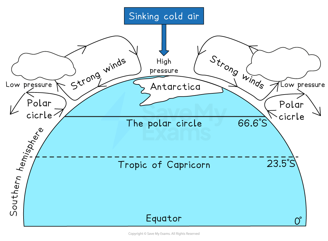
Characteristics of polar regions
Location
Located within the Arctic and Antarctic circles (from 66.5° to 90° N and S)
Antarctica is colder than the Arctic, with average summer temperatures of -28 °C
Climate
Coldest places on Earth
Temperatures very rarely rise above 0°C, with winter temperatures plummeting to -40°C and below
Precipitation is low, with an annual mean precipitation rate of 166 mm as snow
The interior mean precipitation rate is 50 mm
Whereas it is, on average, 200 mm at the coast
Winters are long, cold and windy
Ice caps permanently cover polar regions
Clearly defined seasons of cold summers and even colder winters
The permanent high pressure over polar regions means that dry, cold air sinks over the interior and limits cloud formation and precipitation
At the surface, the cold, dry air flows outwards towards the low-pressure areas at the Arctic and Antarctic Circles, creating strong, unpredictable katabatic winds

Unlock more, it's free!
Join the 100,000+ Students that ❤️ Save My Exams
the (exam) results speak for themselves:

Was this revision note helpful?
