Earth Structure (Cambridge (CIE) IGCSE Environmental Management): Revision Note
Exam code: 0680

How is the Earth structured?
Understanding the Earth’s internal structure is essential to understanding tectonic hazards
The planet is made of several layers, each with different compositions, temperatures, and physical states
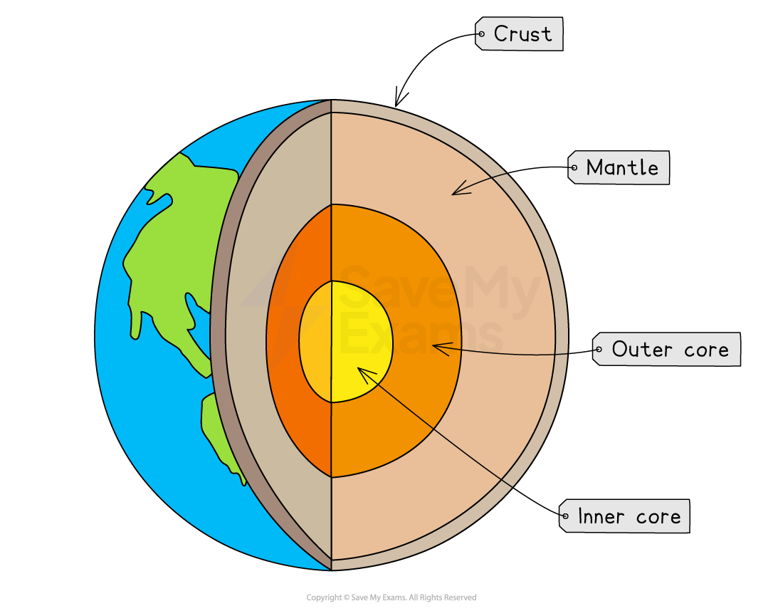
The Earth is composed of three main layers: the crust, mantle and core
Crust
The thin, outermost layer of the Earth
Made of solid rock
Broken into tectonic plates that move slowly across the planet
The thickness varies and it is made up of two types of crust: oceanic and continental
Oceanic crust is thin and dense
Continental crust is thicker and less dense
Mantle
The mantle is the thickest layer, reaching a depth of approximately 2900 km
Mostly semi-molten rock (magma) in the upper mantle and solid in the lower mantle
Heat from the core drives convection currents within the mantle
These convection currents are the engine of plate movement, shaping earthquakes and volcanic activity
Core
Divided into:
Outer core: liquid iron and nickel
Inner core: solid iron and nickel due to immense pressure
Temperatures exceed 5000°C
Heat from the core powers mantle convection
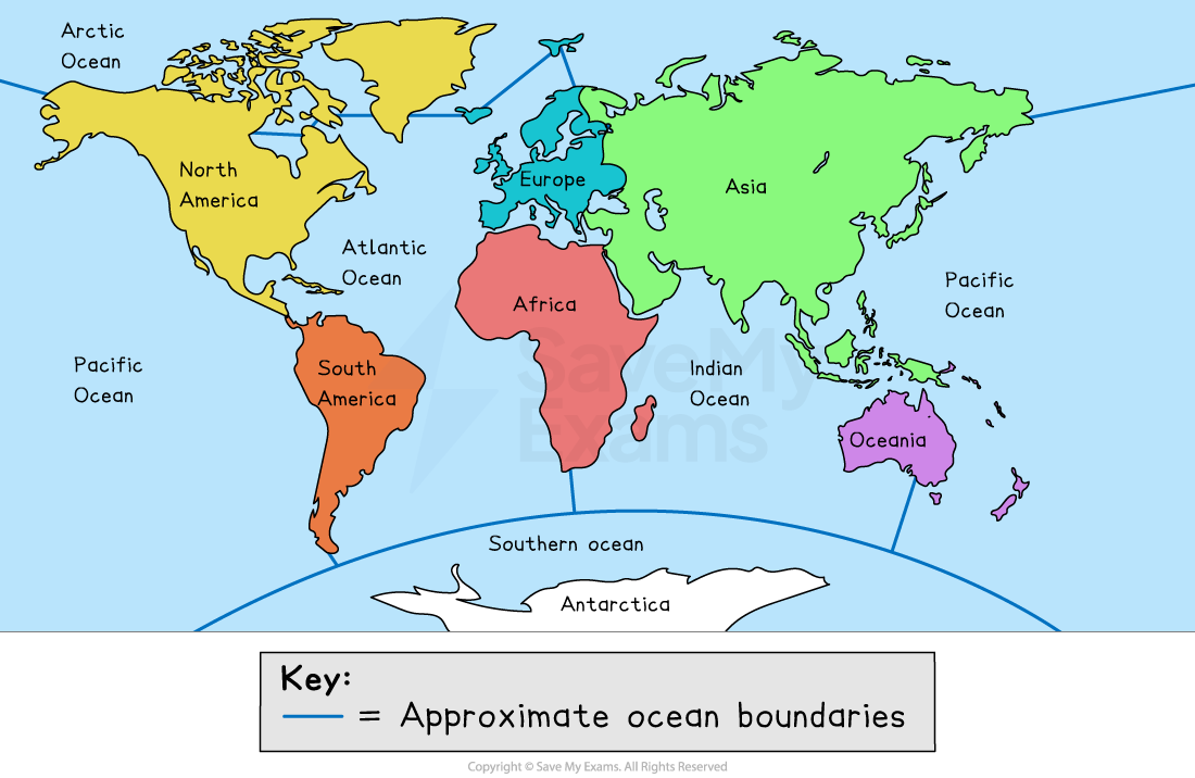
Earth’s continents
Understanding continents helps visualise plate boundaries, earthquake zones and volcano belts
The continents include:
Africa
Antarctica
Asia
Europe
North America
Oceania (including Australia and surrounding islands)
South America
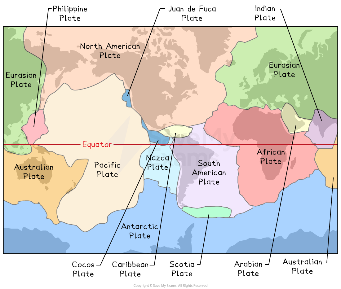
Distribution of earthquakes & volcanoes
Earthquakes and volcanoes do not occur randomly
Their distribution is mainly controlled by the structure and behaviour of tectonic plates
The surface of the Earth is divided into tectonic plates that have moved throughout geological time
The Earth's crust is broken into 15 major tectonic plates and several minor ones
Plates move slowly (mm–cm per year) because of convection currents in the mantle
The place where plates meet is called a plate boundary or plate margin
Tectonic plates move apart, slide against each other, or collide
Earthquakes
The majority of earthquakes (about 95%) occur close to or at a plate boundary
Plates are constantly moving due to mantle convection
Where plates interact—colliding, separating or sliding—stress builds up
This stress is released suddenly as earthquakes

Volcanoes
Like earthquakes, most active volcanoes occur at or near plate boundaries
Many (about 75%) occur around the 'Ring of Fire' surrounding the Pacific Ocean

Patterns to remember:
Pacific Ring of Fire:
A tectonically active region surrounding the Pacific Ocean
It contains ~75% of the world’s volcanoes and frequent major earthquakes
Mid-Atlantic Ridge:
A divergent boundary where new oceanic crust forms, creating volcanic activity and seafloor spreading
San Andreas Fault:
A transform boundary in California known for frequent earthquakes
Hotspots
Volcanic activity can occur far from plate boundaries
A hot spot is an area where plumes of very hot mantle rise towards the surface
The magma rises to the surface through cracks in the crust
Occurs away from the plate boundaries (hotspots usually occur away from plate boundaries, in the middle of tectonic plates)
As plates move over a hotspot, a chain of volcanoes forms, e.g. Hawaii

Hotspot volcanoes tend to produce runny, basaltic lava and create broad shield volcanoes

Unlock more, it's free!
Join the 100,000+ Students that ❤️ Save My Exams
the (exam) results speak for themselves:

Was this revision note helpful?