Syllabus Edition

First teaching 2025

First exams 2027

Tourism (Cambridge (CIE) IGCSE Geography): Exam Questions

Exam code: 0460 & 0976

59 mins14 questions
1a1 mark

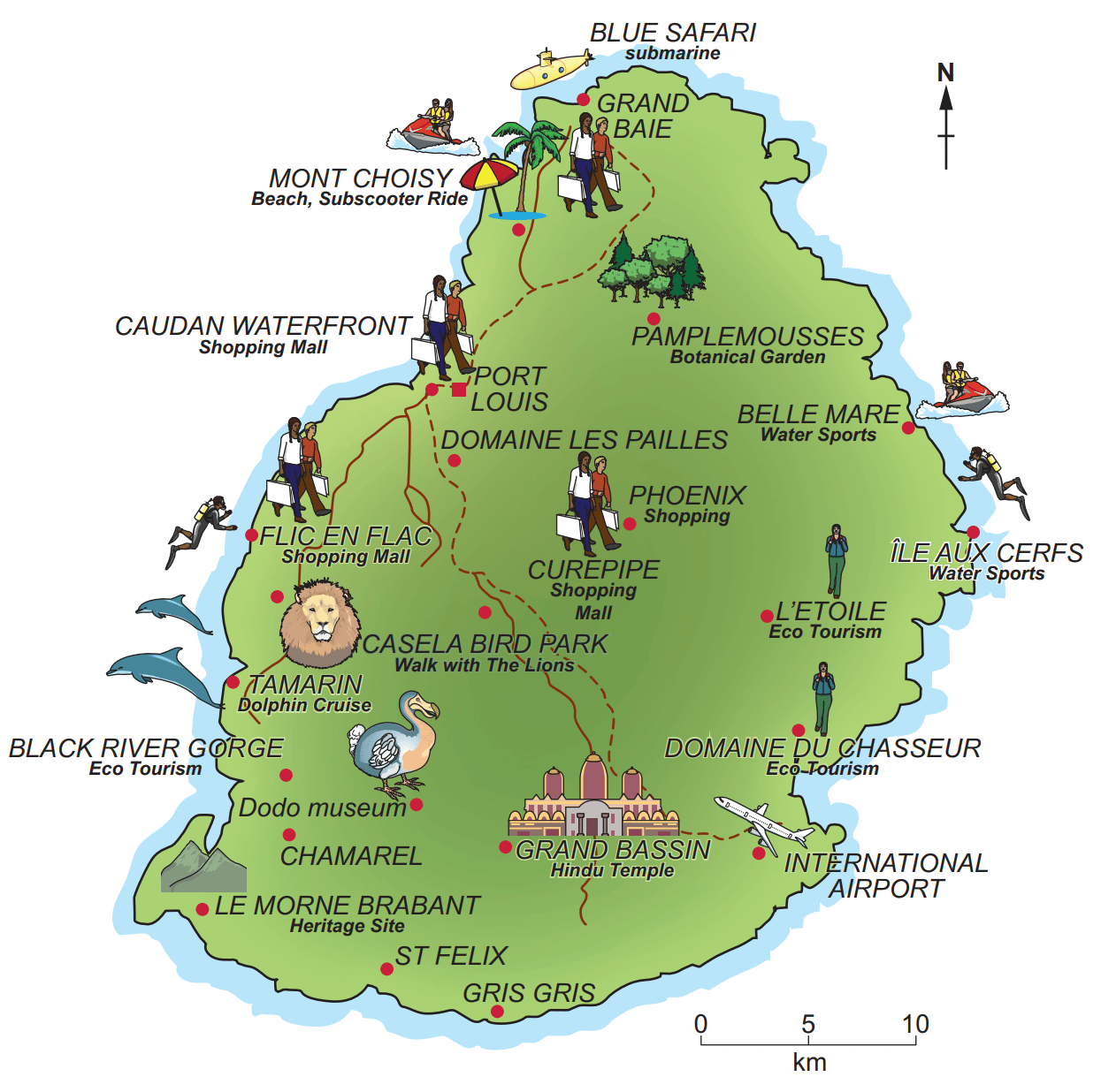
Study Fig. 5.1, which is information about the climate of the Maldives (an LIC).

The Maldives is a group of islands on the Equator in the Indian Ocean, which are important for tourism.

Line graph showing monthly average sunshine hours from January to December, peaking at 270 hours in June, and lowest at 190 hours in December.
Bar chart of average monthly temperature and rainfall; temperature peaks in May, rainfall highest in September; temperature line, rainfall bars.

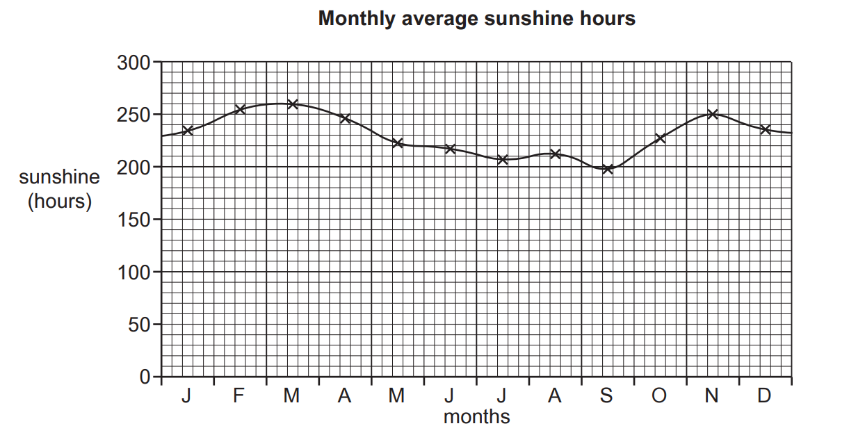
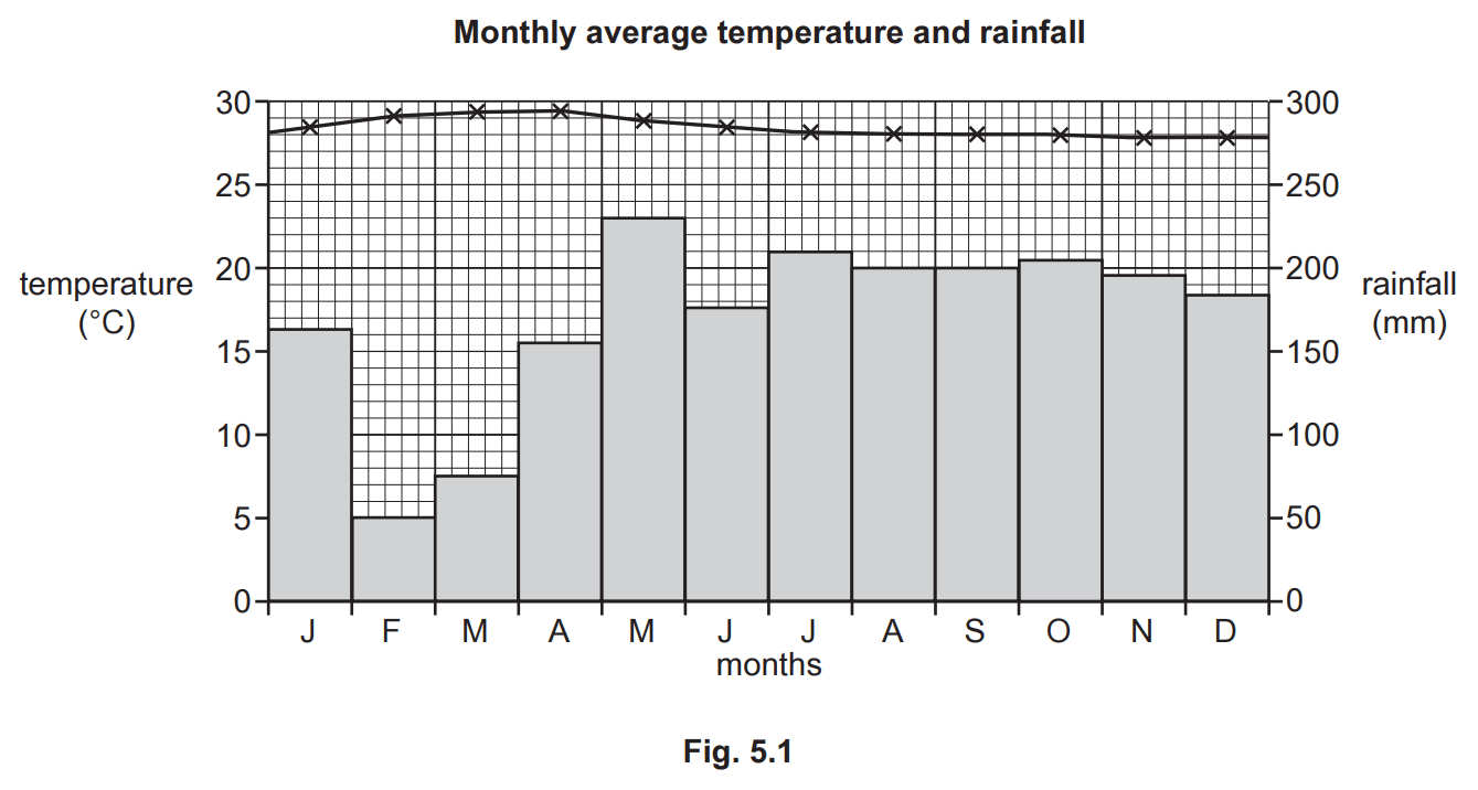
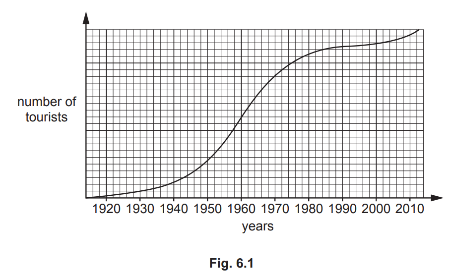
Use Fig. 5.1 to estimate the total annual rainfall in the Maldives.

  • 950 mm 

  • 1750 mm   

  • 2050 mm

  • 3250 mm

1b2 marks

Describe the attractions of the climate of the Maldives for tourists.

23 marks

Describe the characteristics of the physical landscapes of small tropical islands that have encouraged the growth of the tourist industry.

33 marks

Study Fig. 5.1, a map showing tourist attractions in Mauritius, an LIC in the Indian Ocean.

Map of Mauritius depicting locations such as beaches, shopping malls, parks, the airport, and various tourist attractions like water sports, eco-tourism, and a Hindu temple.
Fig. 5.1

Identify three attractions of the human landscape for tourists in Mauritius.

4a1 mark

Study Fig. 6.1, which shows how the number of tourists to Acapulco, a tourist destination on the coast of Mexico, has changed between 1920 and 2010.

Line graph showing tourist numbers from 1920 to 2010. Rapid increase from 1950 to 1980, then stabilised. X-axis: years, Y-axis: number of tourists.

Of the six tourist attractions in Acapulco listed below, identify the two which are physical attractions.

  • Acapulco City market

  • La Quebrada cliffs

  • Lucha Libre Mexican wrestling show

  • Our Lady of Solitude Cathedral

  • Palma Sola archaeological site

  • Playa Condesa beach

4b2 marks

Suggest two ways in which the infrastructure of Acapulco is likely to have improved as it developed as a tourist destination.

4c3 marks

Suggest why the growth of tourism in the Acapulco area may have had both positive and negative effects on local fishermen.

53 marks

Study Fig. 5.1, which shows a map of the island of Gran Canaria, a Spanish island off the coast of Africa. Fig. 5.2, is a photograph of the tourist resort of Taurito in Gran Canaria.

Map of Gran Canaria showing main roads, minor roads, mountain peaks, large settlements, and airport. Key and scale included. North orientation indicated.
Coastal view of a resort with multiple buildings, a large swimming pool with water slides, and rocky cliffs adjacent to the ocean under a clear sky.
Fig. 5.2

Using Fig. 5.2 only, explain how the natural environment has encouraged the development of a tourist resort at Taurito.

63 marks

Examine Fig. 6.1, which provides information about Kafue National Park in Zambia, a region where the tourist industry plays a significant role. Zambia is an LIC in Africa.

Map of Kafue National Park showing tourist camps, roads, and gates. Includes Kafue River, Ngoma Forest, and proximity to Lusaka and Kasempa.
Fig. 6.1

Using Fig. 6.1 only, identify three things that have been done in Kafue National Park to attract tourists.

73 marks

Fig. 6.1 is a map of the Meru National Park in Kenya, an LIC in east Africa.

Map of Meru National Park showing tourist roads, rivers, campsites, gates, Rhino Sanctuary, and key locations like Elsa's Kopje and Adamson Falls.

Using Fig. 6.1 only, identify three tourist attractions that have been provided in Meru National Park.

14 marks

Suggest ways in which the tourist industry is likely to benefit local communities on small tropical islands, such as the Maldives.

24 marks

Study Fig. 5.1, which shows a map of the island of Gran Canaria, a Spanish island off the coast of Africa. Fig. 5.2, is a photograph of the tourist resort of Taurito in Gran Canaria.

Map of Gran Canaria showing main roads, minor roads, mountain peaks, large settlements, and airport. Key and scale included. North orientation indicated.
Coastal view of a resort with multiple buildings, a large swimming pool with water slides, and rocky cliffs adjacent to the ocean under a clear sky.
Fig. 5.2

Suggest two benefits and two disadvantages of tourism for the people who live in Gran Canaria.

34 marks

Examine Fig. 6.1, which provides information about Kafue National Park in Zambia, a region where the tourist industry plays a significant role. Zambia is an LIC in Africa.

Map of Kafue National Park showing tourist camps, roads, and gates. Includes Kafue River, Ngoma Forest, and proximity to Lusaka and Kasempa.
Fig. 6.1

Using Fig. 6.1, suggest reasons why Zambia's government is encouraging tourism.

44 marks

Fig. 6.1 is a map of the Meru National Park in Kenya, an LIC in east Africa.

Map of Meru National Park showing tourist roads, rivers, campsites, gates, Rhino Sanctuary, and key locations like Elsa's Kopje and Adamson Falls.

Suggest what problems the tourist industry may cause for local Kenyan people.

55 marks

Study Fig. 6.2 of a map showing national parks in Namibia, an LIC in Africa.

Map of Namibia highlighting national parks and Windhoek. Parks include Bwabwata, Etosha, and Skeleton Coast, with a salt pan in Etosha.

Explain how national parks help reduce risks to the natural environment in areas where tourism is important.

17 marks

For a named example of a tourist area you have studied, describe the benefits of tourism for local people.

Name of tourist area studied......................

27 marks

For a named example of a tourist area you have studied, evaluate how tourism is being managed sustainably.

Name of tourist area studied: