Syllabus Edition

First teaching 2025

First exams 2027

Cartographic Skills (Cambridge (CIE) IGCSE Geography): Exam Questions

Exam code: 0460 & 0976

26 mins7 questions
1a2 marks

Study the map extract showing part of Kingston, Jamaica (scale 1:50 000). Jamaica is an LIC.

Map extract (opens in a new tab)

Many people work in Kingston. Identify the places where people work using the following grid references.

  1. 693472

  2. 743466

1b1 mark

The runway of Norman Manley International Airport is located in and around grid square 7242.

Measure the length of the runway.

...................................................... km

1c2 marks

Describe the route of the road from the airport to Port Royal, to the west of the airport.

1d2 marks

Identify two services which are located in Port Royal.

2a1 mark

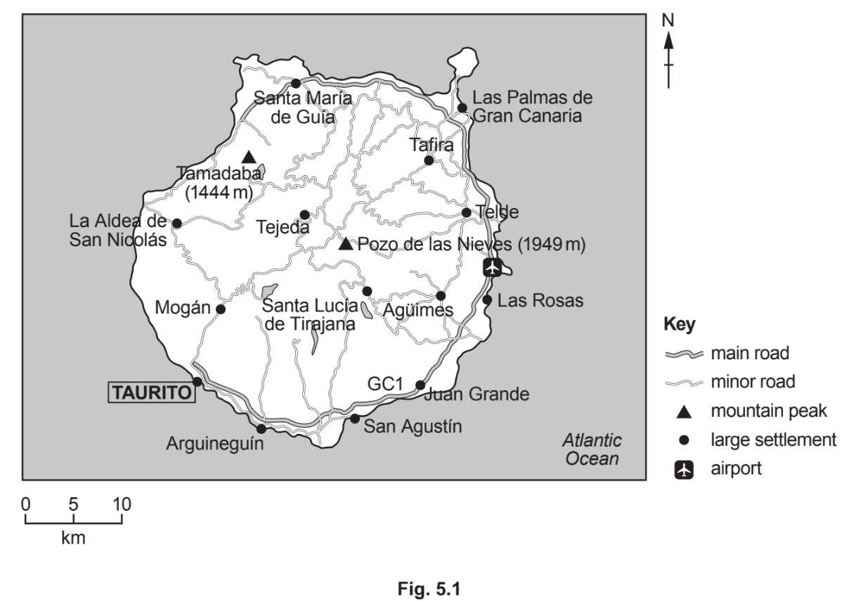
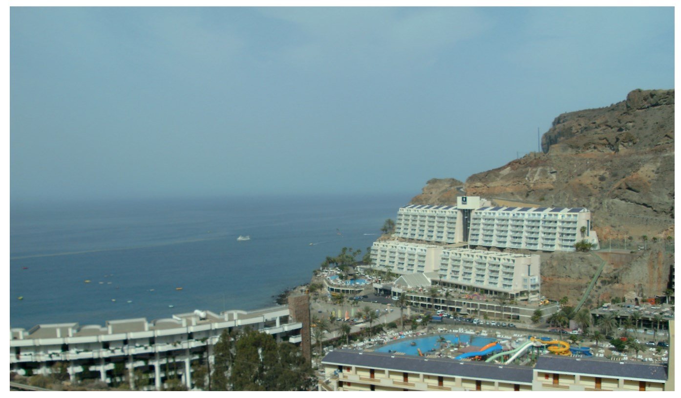
Study Fig. 5.1, which shows a map of the island of Gran Canaria, a Spanish island off the coast of Africa. Fig. 5.2, is a photograph of the tourist resort of Taurito in Gran Canaria.

Map of Gran Canaria showing main roads, minor roads, mountain peaks, large settlements, and airport. Key and scale included. North orientation indicated.
Coastal view of a resort with multiple buildings, a large swimming pool with water slides, and rocky cliffs adjacent to the ocean under a clear sky.
Fig. 5.2

What is the compass direction from the airport to Taurito?

2b2 marks

Use the scale to measure the distance along the GC1 road from the airport to Taurito.

.........................km

3a1 mark

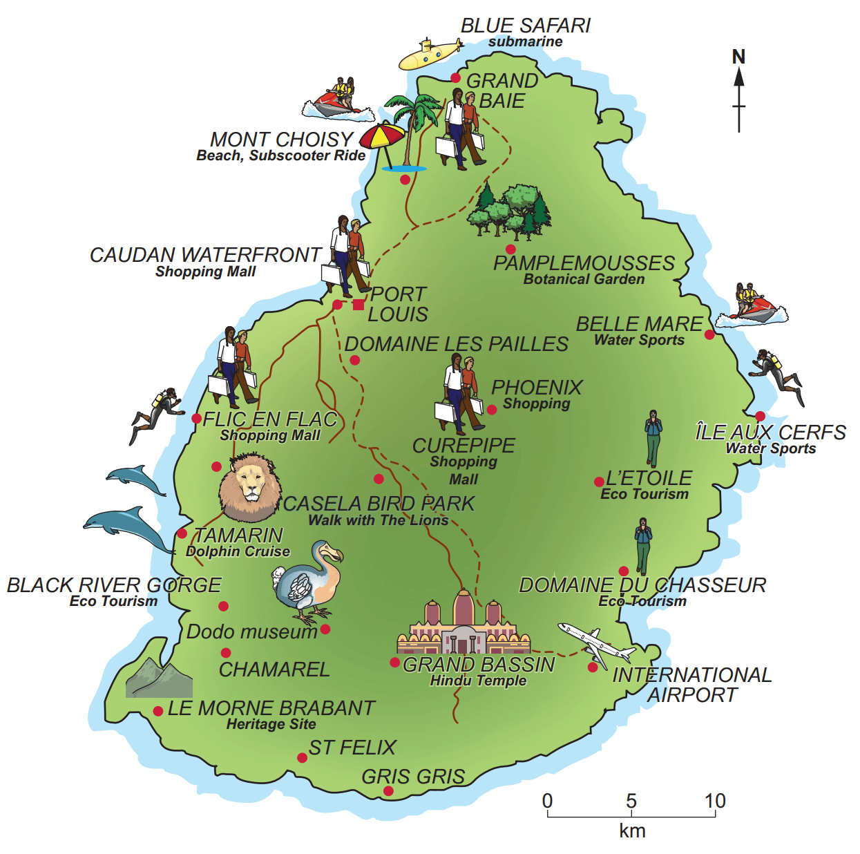
Study Fig. 5.1, a map showing tourist attractions in Mauritius, an LIC in the Indian Ocean.

Map of Mauritius depicting locations such as beaches, shopping malls, parks, the airport, and various tourist attractions like water sports, eco-tourism, and a Hindu temple.
Fig. 5.1

Name the river gorge in the southwest of Mauritius.

3b2 marks

Describe the location of the tourist resort of Grand Baie.

4a1 mark

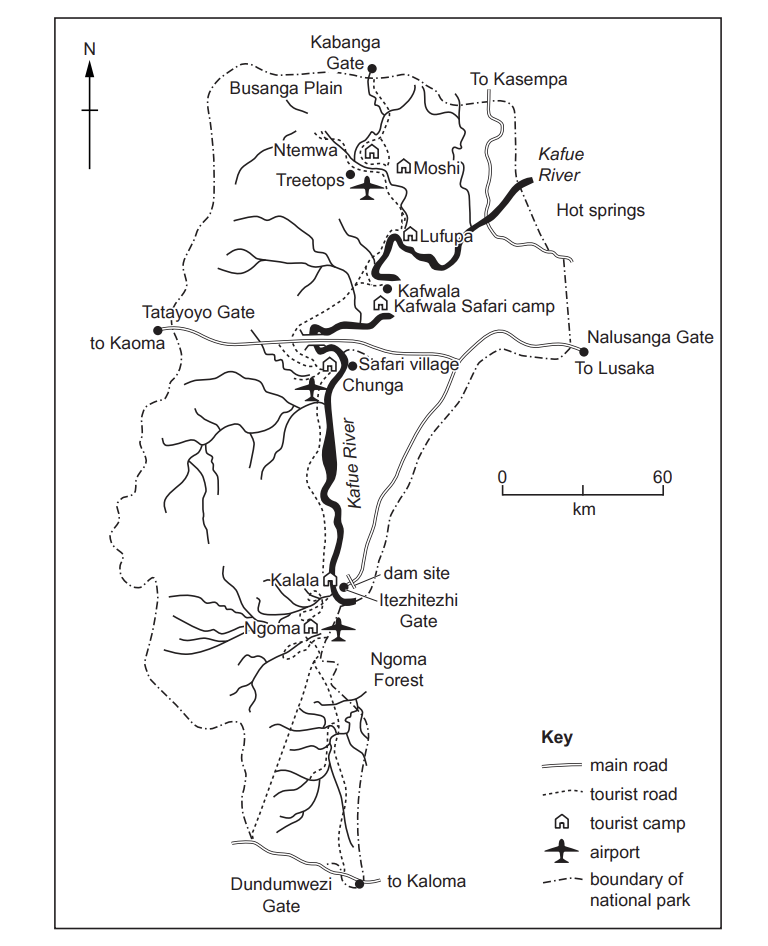
Study Fig. 6.1, which shows information about the Kafue National Park in Zambia, an area where the tourist industry is important. Zambia is an LIC in Africa.

Map of Kafue National Park showing tourist camps, roads, and gates. Includes Kafue River, Ngoma Forest, and proximity to Lusaka and Kasempa.
Fig. 6.1

Estimate the area of Kafue National Park in square kilometres.

  • 1,000

  • 6,000

  • 22,000

  • 100,000

4b2 marks

Many tourists enter Kafue National Park at Nalusanga Gate and drive through it to Tatayoyo Gate.

What is the distance and direction along the main road from Nalusanga Gate to Tatayoyo Gate?

Distance ............................................... km

Direction ..............................................

5a1 mark

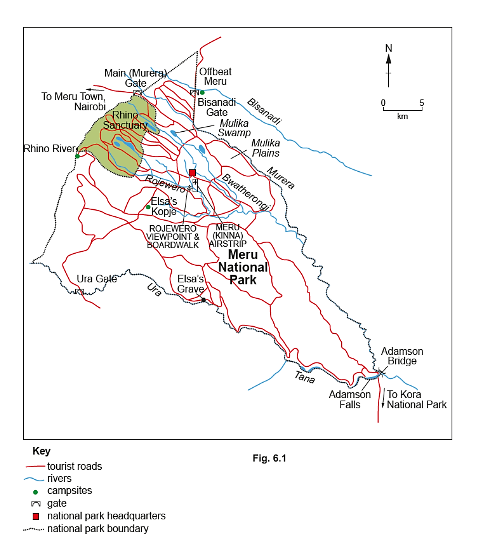
Study Fig. 6.1, a map of the Meru National Park in Kenya, an LIC in east Africa.

Map of Meru National Park showing tourist roads, rivers, campsites, gates, and key locations like the Rhino Sanctuary and park headquarters.

Estimate the area of Meru National Park in square kilometres.

  • 500 km²

  • 1000 km²

  • 3000 km²

  • 10,000 km²

5b2 marks

What is the straight-line distance and direction from Ura Gate to the National Park Headquarters?

Distance ..................................................... km

Compass direction .....................................

63 marks

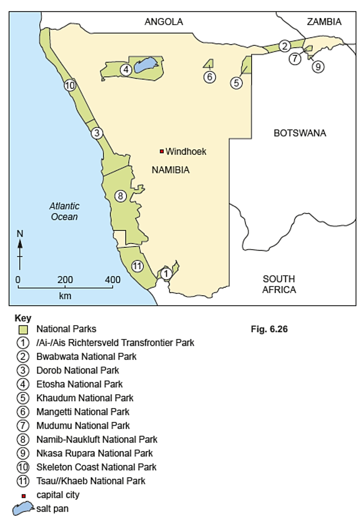
Study Fig. 6.2 of a map showing national parks in Namibia, an LIC in Africa.

Map of Namibia highlighting national parks and Windhoek. Parks include Bwabwata, Etosha, and Skeleton Coast, with a salt pan in Etosha.

Describe the location of the following three national parks in Namibia.

  1. Dorob

  2. Bwabwata

  3. Etosha

14 marks

Study the map extract showing part of Kingston, Jamaica (scale 1:50 000). Jamaica is an LIC.

Map extract (opens in a new tab)

Using map evidence, suggest two advantages and two disadvantages of the location of Norman Manley International Airport.