Syllabus Edition

First teaching 2025

First exams 2027

Coasts: Hazards & Opportunities (Cambridge (CIE) IGCSE Geography): Exam Questions

Exam code: 0460 & 0976

1 hour15 questions
13 marks

Figure 2.2, shows the average monthly frequency of tropical cyclones affecting India’s west and east coasts.

Bar chart comparing average monthly frequency between west and east coasts, with peaks in June, October, and November. West coast leads in October.

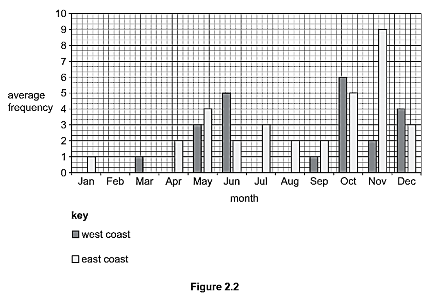
Use Figure 2.2 to compare the average monthly frequency of tropical cyclones on India’s west and east coasts. Refer to data in your answer.

22 marks

Suggest two natural coastal hazards.

32 marks

Study Fig. 1, which are photographs of two contrasting coastal areas

City skyline with cloudy sky and waterfront on the left; tropical huts over water with mountain backdrop and palm trees on the right.

Using Fig. 1, suggest two opportunities for people that a coastline provides.

4a1 mark

Study Fig. 3.1, which is a photograph showing a method of coastal protection.

Pebble beach with a wooden groyne, concrete steps, and metal handrails leading into the sea. Overcast sky and gentle waves breaking onshore.

Fig. 3.1

Describe the beach material in Fig. 3.1.


4b1 mark

Describe the evidence in Fig. 3.1 that the wooden structure is reducing longshore drift.

5a2 marks

Fig. 3.2 shows two methods of coastal protection, F and G.

Pathway flanked by a stone wall on the left and large rocks on the right, leading to a misty hillside with scattered trees and sea views.

Fig. 3.2

Describe the structures F and G.

5b2 marks

Explain how structure G protects the coast.

5c2 marks

Some people think that the coastal protection methods seen in Fig. 3.2 should not have been built.

Explain why people might be opposed to this coastal protection scheme.

15 marks

Evaluate the different ways in which the impacts of tropical storms (cyclones, hurricanes and typhoons) can be managed.

24 marks

Study Fig. 1, which shows sea defences

Wide sandy beach with a stone jetty leading to grass-covered cliffs topped by houses under a partly cloudy sky.

Fig. 1 - Sea defences

Explain how two of the coastal management strategies shown protect the coast from erosion.

35 marks

Study Fig. 1, which shows a discordant coastline.

Geological map showing clay, sand, chalk, and limestone along a coastal area. Features include The Foreland, Peveril Point, and Durlston Head. Key included.

Fig. 1

Explain how The Foreland will change over time.  You may include a diagram in your answer.

45 marks

Study Fig. 4.5, which shows the Godavari sand spit in Andhra Pradesh, India.

fig-4-5

Suggest how coastal processes changed the Godavari sand spit between 1889 and 2015.

55 marks

Study Fig. 3.2 (below), which is a photograph showing an area of mangroves.

Mangrove trees in a coastal wetland with water reflecting their green foliage, a distant mountain under a clear blue sky.

Describe the conditions that are required for the development of mangrove swamps.

17 marks

Explain the importance of coral reefs to a coastal area you have studied.

27 marks

For a named coastal area you have studied, describe attempts to manage erosion.

Name of coastal area...

37 marks

Describe the features of a sand spit and explain how it has been formed. You may include a labelled diagram.

47 marks

For a named tropical storm you have studied, describe the impacts on coastal areas.

Name of tropical storm...

57 marks

For a named coastal area you have studied, explain how the coast provides opportunities for people.

Name of coastal area...