Quantitative & Qualitative Skills (AQA A Level Geography): Exam Questions

Exam code: 7037

30 mins5 questions
1
Sme Calculator
6 marks

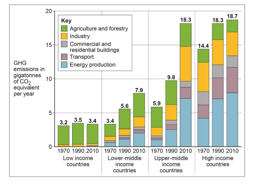
Figure 1 shows rainfall data, a measured hydrograph and a simulated hydrograph for Taguibo Watershed in Mindanao Island, southern Philippines. The data were collected from 13 to 17 April 2007. The simulated hydrograph is a computer-generated prediction of discharge.

Figure 1

fig-1-paper1-june2019-aqa-alevel-geography

b) Analyse the data shown in Figure 1.

[6]

2
Sme Calculator
6 marks

Figure 1 shows the impact of different rates of deforestation and afforestation upon land surface temperature (LST) at different latitudes. The data was collected between 2000 and 2011.

Figure 1

The impact of different rates of deforestation and afforestation upon land surface temperature (LST) at different latitudes. The data was collected between 2000 and 2011.

fig-1-inserts-paper1-nov2021-aqa-alevel-geography

b) Analyse the data shown in Figure 1.

[6]

3
Sme Calculator
6 marks

Figure 1 shows change in greenhouse gas (GHG) emissions, grouped by relative wealth of country, between 1970 and 2010.

Figure 1

fig-1-paper1-june2018-aqa-alevel-geography

b) Analyse the data shown in Figure 1.

[6]

4
6 marks

Figure 1 shows atmospheric CO₂ concentration and net carbon flux from land-use change between 1960 and 2020.

Graph showing atmospheric CO2 concentration (ppm) and net carbon flux from land-use change (Gtc/year) from 1960 to 2020; both rise overall.

Source: Adapted from the Global Carbon Project 2021

Analyse the data shown in Figure 1.

5
6 marks

Figure 1 shows information about freshwater abstraction in Finland in 2020.

Analyse the data shown in Figure 1.

Infographic of UK water cycle showing abstraction sources, uses by sector, evaporation, leaks, wastewater treatment and percentages of water returned to rivers
Figure 1 Information about freshwater abstraction in Finland in 2020