1
4 marks
Outline the role of waves in the transportation of sediments at the coast.
Was this exam question helpful?
Exam code: 7037
Outline the role of waves in the transportation of sediments at the coast.
Was this exam question helpful?
Outline the process of sub-aerial weathering in the development of coastal landscapes.
Was this exam question helpful?
Outline the differences between constructive and destructive waves.
Was this exam question helpful?
Outline the process of longshore drift.
Was this exam question helpful?
Outline the causes of cliff retreat in coastal environments.
Was this exam question helpful?
Outline processes of mass movement at the coastline.
Was this exam question helpful?
Explain the concept of the sediment cell.
[4]
Was this exam question helpful?
Using Figure 7 and your own knowledge, assess the role of mass movement upon the development of this area of the Holderness coastal landscape.
Figure 7

Holderness is overlaid with unconsolidated glacial deposits which lie on top of chalk. The landscape is dominated by deposits of till, boulder clays and glacial lake clays. The glacial deposits form a continuous lowland plain. Rainfall is below national average but the area is prone to heavy storms.
Was this exam question helpful?
Figure 5
The distribution of coastal erosion and accretion (sediment build up) across selected European coastlines in 2004

Figure 5 shows the distribution of coastal erosion and accretion (sediment build up) across selected European coastlines in 2004.
Analyse the data shown in Figure 5.
[6]
Was this exam question helpful?
Figure 5, is an image of the coast in the vicinity of Chabahar Bay, Iran. The image focuses on the movement of sediment in this area
Figure 5

Analyse the data shown in Figure 5.
[6]
Was this exam question helpful?
Using Figure 1 and your own knowledge, assess the effectiveness of hard engineering in managing coastal erosion.
Figure 1: Mean annual cliff retreat rate (metres per year) at three locations on the Holderness coast, 1980–2015
Location | 1980–1991 (before Mappleton groynes) | 1991–2015 (after Mappleton groynes) |
|---|---|---|
Mappleton (protected site) | 2.1 | 0.3 |
0.5 km south of Mappleton | 2.0 | 4.6 |
Withernsea (15 km south) | 2.2 | 2.1 |
Source: adapted from Environment Agency Coastal Flood Boundary dataset and East Riding of Yorkshire Council erosion monitoring surveys, 2015. Mappleton rock armour groynes constructed 1991, cost £2 million.
Was this exam question helpful?
Study Figure 5, which shows the mean size and roundness of pebbles measured at intervals along a shingle beach, starting from the sediment source.
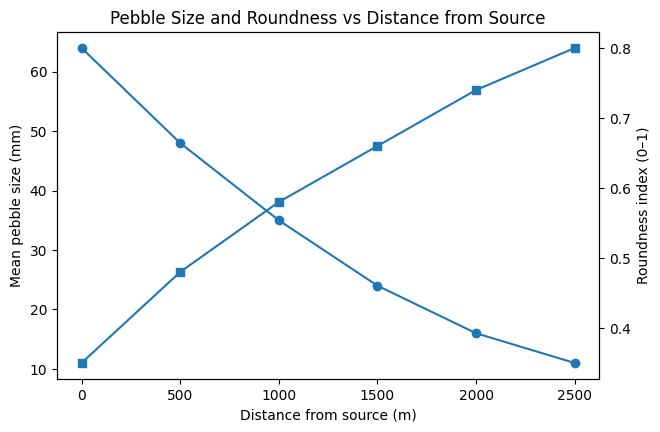
Using Figure 5, analyse the changes in pebble size and roundness shown.
Was this exam question helpful?
With reference to a coastal environment that you have studied, assess the relative importance of marine processes and sub-aerial processes in shaping the coastal landscape.
Was this exam question helpful?
Assess the relative importance of weathering and erosion in the development of coastal landscapes.
[20]
Was this exam question helpful?
'Wave energy is the most important control on the operation of coastal systems.'
To what extent do you agree?
Was this exam question helpful?
Assess the importance of sediment supply in the operation of coastal systems.
Was this exam question helpful?
'The character of a coastline is shaped more by geology than by the processes acting on it.'
To what extent do you agree?
Was this exam question helpful?