Physical Processes &Tectonic Hazards (Edexcel A Level Geography): Revision Note
Exam code: 9GE0

Earthquake Waves & Hazards
The movement felt during an earthquake is the result of seismic waves
These are the released energy radiating through the Earth
There are three types of seismic waves:
Characteristics of Seismic Waves
Wave type | Characteristics |
|---|---|
Primary - P waves |
|
Secondary - S waves |
|
Love - L waves |
|

Primary and secondary hazards
Every earthquake is unique but they have common hazards which are either
Primary (a direct result of the earthquake)
Secondary (a result of the primary hazards)
Primary and Secondary Earthquake Hazards
Primary hazards | Secondary hazards |
|---|---|
Ground shaking Crustal fracturing (when the movement causes the Earth's crust to crack) | Landslides and avalanches - the movement of the Earth may trigger the collapse of material down steep slopes Liquefaction - when the shaking causes particles in the ground to move further apart causing them to act like a liquid rather than a solid Flooding - caused by tsunami |
Volcanic Hazards
Primary and secondary hazards
Although they are all unique, volcanic eruptions have common hazards
Primary (a direct result of the eruption)
Secondary (a result of the primary hazards)
Primary and Secondary Volcano Hazards
Primary hazards | Secondary hazards |
|---|---|
Pyroclastic flow - a mix of dense, hot, rock, ash and gases Lava flow - most move slowly enough that they are not a risk to human life but can reach over 1000oC Ash falls - can travel many km, causing injuries, damage, deaths and disruption to transport Gas eruptions - gases trapped in the magma are released during an eruption, they may form gas clouds which are hazardous to health | Lahars - a mixture of rocks, mud and water which flow down the volcano. They are fast-flowing and destroy everything in their path Jökulhlaups - floods caused by a sudden release of water and rocks when glacial ice is melted by the eruption |
Causes of Tsunami
When an earthquake occurs beneath the sea bed this can lead to a tsunami
As the sea bed jolts water is displaced and forced upwards creating a wave
As the wave approaches the land they slow and the wavelength becomes compressed
This leads to an increase in wave height: they frequently reach 5-10 meters, but can reach 30 meters
As the wave reaches the shore a vacuum is created and the water recedes rapidly out to sea leaving the sea bed exposed

Other causes of tsunami include:
Landslides which may be due to earthquakes and volcanic eruptions displacing the water
Underwater volcanic eruptions
Rarely they can be caused by a meteor strike
Tsunami usually occur close to plate boundaries and are most common in the area surrounding the Pacific Ocean - 'Ring of Fire'
Tsunami travel-time maps
A tsunami travel-time map shows how long a tsunami takes to cross the ocean and reach different coastlines
Scientists use these maps to forecast when a wave will arrive and to warn coastal areas in time
The map below tracks the 2004 Indian Ocean tsunami as it spread out from its source off Sumatra
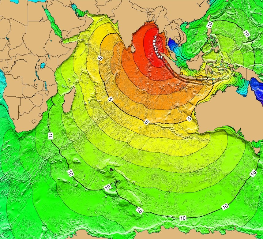
The white dotted line marks the earthquake source, off the west coast of Sumatra
Each curved line is a contour that shows how far the wave had reached after a set time
The numbers on the contours show the time in hours after the earthquake
Coasts nearest the source were hit first:
Northern Sumatra in under 30 minutes
Sri Lanka and southern India in about 2 hours
Coasts further away were hit later:
East Africa after about 7 to 10 hours
The wave moves faster over deep ocean and slows down in shallow water near the coast
The map shows arrival times only, not the height or strength of the wave

Unlock more, it's free!
Join the 100,000+ Students that ❤️ Save My Exams
the (exam) results speak for themselves:

Was this revision note helpful?
Build on this topic