13 marks
Study Figure 1.

Figure 1: A map showing vacant land in Detroit (USA)
Suggest one reason for the pattern of vacant land in Detroit.
Was this exam question helpful?
Exam code: 9GE0
Study Figure 1.
Figure 1: A map showing vacant land in Detroit (USA)
Suggest one reason for the pattern of vacant land in Detroit.
Was this exam question helpful?
Study Figure 2.

Figure 2
Information about four urban places compared to the UK average, 2018
Suggest one reason average wages per week differ between urban places.
Was this exam question helpful?
Study Figure 3.

Figure 3
Changes in unemployment rates in Hartlepool (urban area in north-east England) and England between 2004 and 2018
Suggest one reason why the unemployment rates for Hartlepool have varied.
Was this exam question helpful?
Study Figure 2.
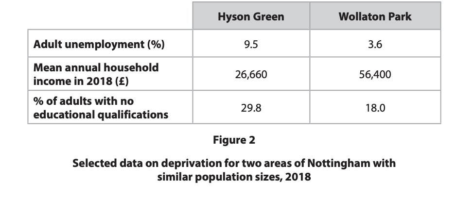
Suggest one reason for the difference in adult unemployment in these areas.
Was this exam question helpful?
Study Figure 1.
Figure 1: Index of Multiple Deprivation decile ranks, 2019
(1 = most deprived 10% of places in England, 10 = least deprived)
Category | Middlesbrough | Reading |
|---|---|---|
Income | 1 | 8 |
Employment | 1 | 8 |
Health | 1 | 7 |
Education | 1 | 7 |
Living environment | 1 | 7 |
Suggest one reason why levels of deprivation differ between the two places shown.
Was this exam question helpful?
Study Figure 1.
Figure 1: Average pay in two UK places (2020)
Measure | Reading | Middlesbrough |
|---|---|---|
Average male hourly pay | £16.73 | £13.13 |
Average full-time female weekly pay | £621 | £509 |
Suggest one reason why average wages differ between the two places shown.
Was this exam question helpful?
Study Figure 1.
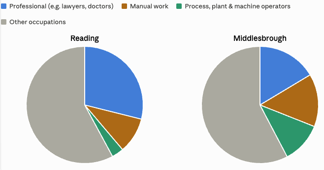
Suggest one reason why the proportion of people in professional jobs differs between these places.
Was this exam question helpful?
Study Figure 1.
Figure 1: Selected economic data for two UK places
Measure | Reading | Middlesbrough |
|---|---|---|
Gross Value Added (GVA) per person | £48,377 | £16,856 |
Average house price (2022) | £433,063 | £149,983 |
Adults with a university qualification | 43% | 19% |
Suggest one way the data shows that one place is more economically successful than the other.
Was this exam question helpful?
Study Figure 1.
Figure 1: A map showing vacant land in Detroit (USA)
Suggest reasons for the relationship between proportion of vacant land and distance from the CBD of Detroit.
Was this exam question helpful?
Study Figure 2.
Figure 2
Information about four urban places compared to the UK average, 2018
Suggest why urban places in less successful regions may suffer from a spiral of decline.
Was this exam question helpful?
You have studied your local place and a contrasting place. Explain the changes in the demographic characteristics of one of these places.
Was this exam question helpful?
Study Figure 3.
Figure 3
Changes in unemployment rates in Hartlepool (urban area in north-east England) and England between 2004 and 2018
Suggest possible reasons why Hartlepool’s unemployment rates are likely to remain higher than those of England.
Was this exam question helpful?
Explain how international and global influences have shaped the social characteristics of your local place.
Was this exam question helpful?
Study Figure 2.
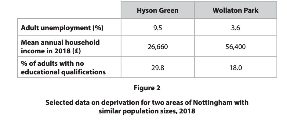
Explain why there may be changes over time in the levels of deprivation of these areas.
Was this exam question helpful?
Explain the reasons for variation in the functions of your two chosen places.
Was this exam question helpful?
With reference to Figure 2a and 2b and your own knowledge and understanding:
Economic and Social Data | Flanders region (northern Belgium) | Walloon region (southern Belgium) |
Population (million) | 5.5 | 0.67 |
GDP € per capita per year | €41,000 | €25,000 |
Unemployment (%) | 5.2 (33% long term) | 11.5 (56% long term) |
ICT and finance contribution to GVA (Gross Value Added) (%) | 23 | 5 |
Main types of employment in 19th/20th century | Agriculture | Coal mining, heavy industry |
Main types of employment in 21st century |
|
|
% speaking English | 50 | 20 |
% with tertiary education | 37.2 | 33.9 |
Life expectancy in years (2016) | 81.2 | 79.6 |
Transport links |
|
|
Environmental quality | High atmospheric pollutant levels from traffic and limited open space and forests, means that the region frequently exceeds European targets for air quality | Atmospheric pollutant levels are dropping. The region usually meets European targets for air quality. Dense forests and parks cover parts of the region |
Figure 2a
Economic and social data for two contrasting regions of Belgium

Figure 2b
Map of Flanders and Walloon regions in Belgium in 2016
Evaluate the reasons why some regions are more successful than others.
Was this exam question helpful?
For your local place and your contrasting place, evaluate the view that low income is the most important factor leading to deprivation.
Was this exam question helpful?
Evaluate the extent to which past and present connections shape the economic and social characteristics of your chosen place.
Was this exam question helpful?