Atmospheric Circulation (College Board AP® Environmental Science): Study Guide

Atmospheric circulation & global wind patterns
Global atmospheric circulation can be described as the worldwide system of winds that move solar heat energy from the equator to the poles to reach a balance in temperature
Wind formation
Air always moves from areas of higher pressure to lower pressure and this movement of air generates wind
Winds are large scale movements of air due to differences in air pressure
This pressure difference is because the Sun heats the Earth's surface unevenly
Insolation that reaches the Earth's surface is greater at the equator than at the poles
This is due to the Earth's curvature and the angle of the Earth's tilt
For a full explanation of why insolation varies with latitude, see Solar Radiation & Earth's Seasons — Effect of latitude on insolation
This irregular heating of the Earth’s surface creates pressure cells
In these pressure cells, hot air rises and cooler air sinks through the process of convection
The amount of water vapour that air can hold depends on its temperature — warm air can hold more water vapour than cool air
As warm, moist air rises along the equatorial branch of a Hadley cell, it cools, and its capacity to hold water vapour drops
The vapour condenses out as clouds and heavy rainfall, which is why tropical rainforests are concentrated near the equator
The opposite happens around 30°N and 30°S: descending air warms, regaining water-vapour capacity, so it dries out
This is why the world's major deserts (Sahara, Arabian, Atacama, Australian outback, Kalahari) cluster at these latitudes
Air movement within the cell is roughly circular and moves surplus heat from equatorial regions to other parts of the Earth
In both hemispheres (the Northern hemisphere and the Southern hemisphere), heat energy transfer occurs where different atmospheric circulation cells meet
There are three types of cell
Each cell generates different weather patterns
These are the Hadley, Ferrel and Polar cells
Together, these three cells make up the tricellular model of atmospheric circulation:

The tricellular atmospheric wind model
Each hemisphere has three cells (Hadley, Ferrel, Polar) that circulate air between the surface and the upper atmosphere
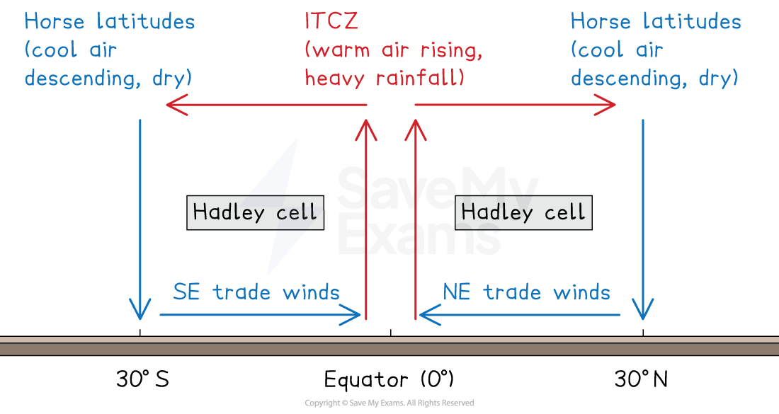
The Hadley cell is the largest cell, extending from the equator to about 30°N and 30°S
Surface winds in this cell are the trade winds
In the Northern Hemisphere these blow as NE trade winds
In the Southern Hemisphere they blow as SE trade winds
The trade winds converge at the equator at the Intertropical Convergence Zone (ITCZ)
At the ITCZ, warm rising air produces heavy rainfall and thunderstorms
The descending branch around 30°N and 30°S forms the horse latitudes
The world's major hot deserts are concentrated at these latitudes
The Ferrel cell is the middle cell, lying between roughly 30° and 60° north and south
The Polar cell is the smallest and weakest, lying between roughly 60° and the poles

Coriolis effect
Each cell has prevailing winds associated with it
These winds are influenced by the Coriolis effect
The Coriolis effect is the appearance that global winds and ocean currents curve as they move
The curve is due to the Earth's rotation on its axis, and this forces the winds to actually blow diagonally
The Coriolis effect influences wind direction around the world in this way:
In the northern hemisphere, it curves the winds to the right
In the southern hemisphere, it curves them left
The exception is when there is a low-pressure system:
In these systems, the winds flow in reverse (counterclockwise in the northern hemisphere and clockwise in the southern hemisphere)
Global wind belts: surface winds
The combination of pressure cells, the Coriolis effect, and the 3 cells produces wind belts in each hemisphere:
The trade winds blow from the subtropical high-pressure belts (30° north and south) towards the Equator's low-pressure zones and are deflected by the Coriolis force
The westerlies blow from the sub-tropical high-pressure belts to the mid-latitude low areas but again are deflected by the Coriolis force
The easterlies, polar easterlies, meet the westerlies at 60° south

Unlock more, it's free!
Join the 100,000+ Students that ❤️ Save My Exams
the (exam) results speak for themselves:

Was this revision note helpful?
Build on this topic
